Showing posts with label basalt. Show all posts

Wednesday, 14 October 2015

FL20151011 - Into the east

The longest day so far in this season’s reconnaissance flights.

We had a very ambitious trip planned to circumnavigate the Badia region, the Panhandle, or what I like to refer to as the “black basalt desert’. The furthest point of our flight is the air base at Ruweishid, some 116 nm from Amman; a place we have come to grudgingly love over the years.

The trip involved three re-fuellings and well over the 70 sites scheduled were photographed; the pilots were two of the best in that we flew higher than is normal (as most helicopter pilot like to fly low) and responded perfectly to our needs, orbiting the sites as directed.

We started the day photographing a site that we had been informed was targeted in what can only be described as a mindless act - a huge scoop taken out of the side of Qasr Mushash by heavy machinery. This is a site we have photographed many times, and seeing it so altered after surviving so many years at the mercy of the elements (it is directly alongside a wadi) is such a shame. We are informed that the Department of Antiquities has been informed of the damage and we hope the site is successfully stabilised.
Qasr Mushash, with the offending gouge clearly evident.
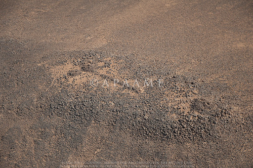
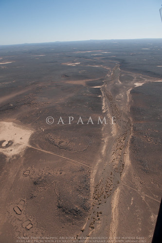
We have done many trips in this region but today we targeted areas in the northern sector as we had not flown so often here (but we had to stay at least 10 nm from the borders). What struck me was that there were a number of small rectangular features and collapsed stone piles in this area; there is of course a plethora of wheels and circular enclosures as well as our favourite “kite” sites, draping the basalt landscape. These rectangular and other structures, which we are told should be referred to as ghurra huts, are most likely to date from the Early Bronze Age.
A cluster of 'Ghurra Huts' in the landscape.
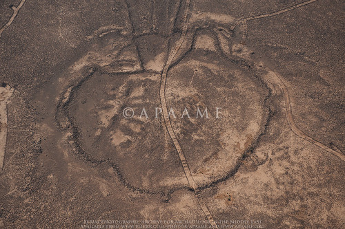
There were places which were particularly important or notable. One was what we loosely referred to as a hillfort; it looks to be fortified – there are clear double faced walls, and it is clearly in a defensible location on a hill top or ridge of basalt. But what is its history, or prehistory? We were accompanied on the flight by Bernd Müller-Neuhof, (of the DAI) who had supplied most of the targets for the day. He plans to visit this site next April and discover more about it.
The fortified 'hill fort'.
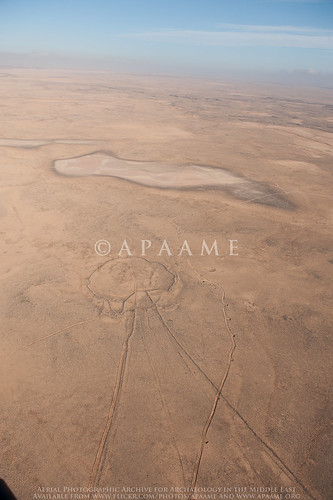
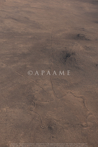
The other striking place was what looked to me like a remnant of a small volcano, with 70% of its caldera still intact, or possibly the edge of a basalt flow masquerading as such. Two kites use the outer edges of the caldera slopes at the point where the tails merge to form a narrow neck before the head. The sites obviously made the most of the hill and slope (presumably for hunting). Again this is not a place that has been explored but I am beginning to think a field trip out there next year would be very useful and rewarding.
Two kites flanking and using the geology of the basalt landscape.
The logistics of these longer trips means re-fuelling at numerous different places, the furthest away being Ruweishid; this always adds spice to our day with a variety of cups or glasses of tea or coffee with the local squadrons, and we have learnt to bring our own supply of food too. Starting at seven in the morning and finishing the flying at around two o’clock in the afternoon is a severe test of stamina if there isn’t some nourishment and liquid intake.

Even though our day was long, we had intended to photograph further sites in the south of the Panhandle for the Jebel Qurma Project, but sadly this could not be achieved. There is always next season, إن شاء الله (Insha'Allah).
The flight team for FL20151011.
Although tired after such a long day it is also very stimulating (and rewarding) to have seen such interesting and often unrecorded archaeological landscapes. We hope that future research can enlighten us as to the nature and origins of these sites in this most dramatic, and now barren, place.

Saturday, 25 October 2014

Filming in Azraq

Friday 24th October. Up before sunrise, left Amman with a film crew and headed east to Azraq.

David Kennedy on the Umayyad reservoir wall - Azraq Wetland Reserve.
The day began with some shooting at Azraq Wetland Reserve. While there we took the opportunity to photograph the Umayyad reservoir wall. Sadly the oasis has greatly diminished in size in the last twenty years. Despite the Water authority pumping 1.5 to 2.5 million cubic metres of water into the wetlands each year, it is not enough to replenish the excessive pumping of water out of the oasis and, sadly, it is still shrinking in size.

Filming at Azraq Wheel 82
From there we headed out into the basalt desert to visit a Wheel and a Kite. We drove as far as the 4WD could take us across the mudflats, from there a somewhat arduous trek across the volcanic rocks to the site of interest. Even in this rather remote location we saw signs of recent looting – a bucket and pick axe inside the Wheel!


Looter's tools - Azraq Wheel 82
As one can see from the ground photo above, these stone structures don’t look very impressive, if they are noticed at all, when on foot. However, when seen from above, through aerial photography or satellite imagery, a very different picture emerges.
Azraq Wheel Group B. © APAAME_19970527_DLK-0157
Azraq Kite 81, Wheels 191, 192, 193. ©APAAME_20120522_DLK-0589
Returning to the Azraq Lodge (converted former British military hospital) in the evening for some final recording before heading back to Amman for a well earned dinner. 

Thursday, 12 September 2013

Research: Harrat Khaybar

For quite some time now I have been working on a large group of kites we found in a high resolution window in Google Earth around the ancient oasis and site of Khaybar. The huge concentration of kites fascinated us, so we have been conducting a comprehensive study and gathering data on the kites. This has included taking measurements, mapping, drawing and creating typologies.

While I have been working away I have constantly been struck by the ‘grass is always greener’ mentality, and wondered what lay behind the fuzzy pixels of the lower resolution imagery around my high resolution window in Google Earth. Well, that was answered for me today by Bing maps. My window has been completely blown open, and though for brevity and time’s sake I shall no doubt have to limit my study to the original window in Google Earth, the additional information provided by the larger context is incredibly helpful.

Firstly, I can confirm my suspicions of patterns:– the amazing series of kites that almost appear strung together by their tails that are located to the east of Khaybar have sister strings to the south of the high resolution window.
A string of Kites from east of Khaybar (drawn: Rebecca Banks).
Secondly, a report with accompanying photography by M. John Roobol and Victor E. Camp in their ‘Explanatory Notes to the Geologic Map of the Cenozoic Lava Fields of Harrats Khaybar, Ithnayn, and Kura, Kingdom of Saudi Arabia’ (1991) that showed what appeared to be a Kite stratified underneath a tongue of Pahoehoe lava of the Habir flow could be identified in the satellite imagery. The area reveals at least one Kite partly overlain by the lava flow – and several other stone structures as well. The Habir flow is ‘historic’ but the exact date is unknown – the eruption date could be anything between the 1st century AD and 1800 (Roobol & Camp: 23).

Saturday, 27 April 2013

Flight 20130418 - Modern traces in an ancient lanscape

Bedouin tents near Azraq. The outline left by a tent (centre) is a common site when flying over the Panhandle of Jordan ©APAAME_20130418_MND-0189.
Flying over the Basalt Desert in the Jordanian Panhandle with its profuse scattering of ancient stone structures of Kites, Pendants, Wheels and others it is often easy to forget that this stark landscape is still traversed and used by modern Bedouin. During our last flight, we saw some tangible evidence of this - with what appear to be modern structures built alongside the old.
Bedouin Mosque - the outline of a mosque is created using the basalt stones in a cleared area. It is identifiable as a mosque due to the addition of a 'mirhab' (centre of photo - click to enlarge) © APAAME_20130418_MND-0324.
Modern? 'graves' side by side located next to a wheel (see below). © APAAME_20130418_MND-0551.
Ausaji Wheel 231 with 'graves' visible to the right of picture © APAAME_20130418_MND-0552.

Friday, 17 August 2012

Guest blog: Gary Rollefson and the Eastern Desert of Jordan

Research in the Eastern Desert of Jordan
2011 and 2012 
Prof. Garry Rollefson, Whitman College
Man made structures in the vicinity of Wisad Pools. Structure W-66 indicated. APAAME_20080909_DLK-0361. Photographer: David L Kennedy. Click to enlarge.
In 2007, when Alex Wasse and I revisited Wisad Pools in Jordan’s panhandle, we were stunned at the density of man-made structures at what appeared to be an enormous necropolis situated around a number of natural pools in a short wadi that collected rainfall during the rainy season. In the same summer we visited M-4 (“Maitland’s Mesa”) in the Wadi al-Qattafi, where there were clear pastoral structures on the top of this mesa as well as a tower tomb and a string of more than 50 rectilinear chambers extending from it along the southern edge of the mesa. In addition, there were numerous structures along the southern, western, and northern slopes, several of which showed striking parallels with nawamis tombs that had been reported from the Sinai and Yemen deserts. Since these two sites are currently characterized by hyperarid climatic condition, conventional wisdom and our own inclinations considered all of the basalt structures to be ritual in nature due to the effort necessary to construct them and to the ephemeral nature of most pastoral architecture. In our mind, these structures were permanent monuments to the dead, whether tumuli or cenotaphs. This interpretation proved to be incorrect, and although there are clear ritual structures at Wadi al-Qattafi and at Wisad Pools, many of the permanent structures are, in fact, domestic dwellings that imply some degree of permanence in occupation.

Tuesday, 5 June 2012

Flight 20120520: Now online

Our first flight for 2012 is now uploaded to our flickr archive. You can browse the images here.

This flight focused on the stone built structures known as Kites located in the basalt desert of Jordan, but also captured other structures known as Wheels and Pendants. In particular, we were interested in the landscape and other structures surrounding the Kites, and how these features interact.

Here are some highlights. Please click on the images to enlarge (you will be sent to the image on our flickr site).

Hibabiya Kite 55
Hibabiya Kite 55 
 
Amra Kite 22 
 
Ausaji Pendant 16, Ausaji Cairns 9, Ausaji Cairns 8 
 
Ausaji Wadi 1 
 
Ausaji Wheel 20, Ausaji Kite 19, Ausaji Wheel 81

Wednesday, 23 May 2012

Flight 20120522 Taster- Pendant and Wheel

APAAME_20120522_DLK-0095. Photographer: David L. Kennedy. Click to enlarge.
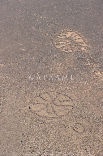
Fantastic example of a Bullseye Pendant, with a tail constructed of small cairns, and a Wheel, with spokes radiating from a central 'hub'.


Thursday, 16 February 2012

Pic of the day : Qattafi Mesa 7

Qattafi Mesa 7 (Boyer's Butte), Qattafi Cairns 4, Qattafi Cairns 14, Qattafi Mesa 5. Photograph: David Kennedy APAAME_20111027_DLK-0677
This mesa in the basalt desert of Jordan is very remote, but the cairns on the surface have been illicitly excavated. When we recently visited this site the surface was strewn with both modern and ancient inscriptions on the basalt boulders, testimony that despite its remote location it is has been a popular 'spot' for centuries. And why not?- as you can see the view is simply breathtaking.

Tuesday, 18 October 2011

Roadtripping to Mesa Country

We awoke in the very small hours of Sunday morning to set out to a special area of Jordan - Mesa Country.

East of Azraq on the edge of the Harrat ash-Sham lie a series of Basalt mesas (flat topped hills). On and around these mesas are an assortment of stone built structures - Wheels, Kites, Cairns, Tower Tombs and Pendants, which in this region were first described in the 1920s by pilots of the Royal Air Force on the Cairo-Baghdad airmail route. It was this landscape that we set out to investigate.

We broke from the main road at dawn and watched the sun rise over the desert as we rattled our way slowly down a questionable track - often no more than a pair of wheel ruts over the pebbly desert floor. Our first stopping point was a couple of Wheels surrounded by Cairn Rings. These were almost unrecognisable from the road, but as we got closer the walls began to be apparent. One was nestled in the slope of the hill while the other lay prominently on top of a rise of basalt boulders. Between these Wheels was a Bullseye Cairn - unfortunately illicitly excavated - but still associated with some Safaitic inscriptions and flint artefacts.

Wheel
Rajil Wheel with Cairn Ring in the early morning sun. Photographed by Rebecca Banks.
We then returned to our trusty 4WDs (the tyres were unfortunately not so trusty) and continued on our way east. We knew we were getting close when the landscape changed to this:

Mesas
Mesas in the Qattafi area. Photographed by Rebecca Banks
On the agenda was climbing four of this group of Mesas - Qattafi Mesa 2 (named 'Tell A' by Rees, an RAF pilot), Mesa 3, 'Maitland's Fort' (Mesa 4, again named by an RAF pilot) and Mesa 7 or 'Boyer's Butte' as we have come to know it. It sounds easy, but when you have one of these sitting infront of you, you begin to doubt your fearless leader. After a bit of courage and some concentration not to put your weight on the wrong boulder, you reach the top and the view is absolutely breathtaking. Not a living soul in sight, and the only noise is the wind.

The most prominent features of these mesas are Tower Tomb Cairns, visible as small 'pimples' on their surfaces, easily visible from surprisingly far away. The size of the rounded basalt boulders on these mesas provide the perfect building material to construct these large burial mounds and other features. On two of the mesas, these Tower Tombs were incorporated into Pendants - a tail of smaller cairns connected to the larger burial cairn at the head. Other cairns also littered the surface of the mesas, but it was predominantly the Tower Tombs that had associated inscriptions, varying from ancient to modern.

Tower Tomb Cairn
Tower Tomb on Qattafi Mesa 7. Photographed by Rebecca Banks

Inscription Qattafi Pendant 3
Inscription associated with Qattafi Pendant 3 on Mesa 2. Photographed by Rebecca Banks
Unfortunately many of the cairns we came across had been illicitly excavated, with the interiors hollowed out by those looking for burials and assosciated grave goods. As a result it will be very difficult to verify how many of these cairns were indeed used for burials, or whether they served another purpose.

Qattafi Pendant 4 Head
An illictly excavated cairn (Qattafi Pendant 4) on 'Maitland's Fort'. Photographed by Rebecca Banks
Driving out into this country has its rewards, but the journey is not to be taken lightly. The rough terrain means that a punctured tyre is more than likely, and the lack of mobile phone reception makes a satellite telephone a must! Thankfully this time we suffered from only one punctured tyre...

Karen points the finger
Our Pajero after running afoul of a wayward stone. Photographed by Rebecca Banks.

Monday, 17 October 2011

Desert inscriptions

Safaitic, Greek and Arabic inscriptions are found all through the basalt deserts of Jordan and beyond, sometimes in proximity to ancient Cairns and other structures - but not all of them are ancient. Here are some we came across yesterday on the top of the basalt Mesas east of Azraq that we suspect are a little more modern. What could have made us so suspicious?

An Arabic inscription on Qattafi Mesa 7. Photo: Bob Bewley.

An Arabic inscription on a tower tomb atop Qattafi Mesa 3. Photo: Rebecca Banks.

Friday, 16 September 2011

Wheels: stone built structures of the Harrat ash-Sham


A simple Wheel (Aritein Wheel 5) with nine spokes radiating from a central point and no hub.

The Wheels of northeast Jordan are so-called due to their most common form, a circular structure with low stone walls, and lines radiating from a central point like spokes. Little is known of these sites beyond their type and location, as there has been little archaeological investigation.They were probably amongst the 'circles' mentioned by Rees in 1929. In the 1970s they were studied simultaneously by Helms and Betts (who called their examples 'Jellyfish') and Kennedy and Riley (who preferred 'Wheel (enclosure)'). There are large numbers across the Harrat ash-Shaam of Jordan, and the numbers possibly exceed 1000.

Aritein Wheel 2 seen from ground level. The crumbling low walls can be seen just before the horizon. Photo: Karen Henderson.
The walls are very low on the Wheels, and are built without mortar or shaping of the stone. Although they are well known from aerial photographs and satellite imagery, the structures themselves can be easily missed in the landscape. Betts (1984: 29) notes that when surveying Wheels on the ground, they are so ephemeral as to go unnoticed if one does not already know they are there. The above photograph shows the very slightly raised and darker rocks of a Wheel in the Aritein area, demonstrating how hard they can be to see on the ground.

A plan drawn from a very faint Google Earth image of a singular Wheel found outside the basalt area.

Wheels have large variations in size and type, but they seem to be almost entirely confined to the Harrat ash-Shaam. The only possible example found just outside of the basalt cover in the north of the panhandle is extremely faint and hard to identify. Despite its faintness, the structure appears to be of a coommon form – a large central open hub with straight spokes, and possibly an exterior wall or ring of Cairns around the outside. The mud pan that it sits on makes it very difficult to see, and it is possible there are other examples in the limestone steppe east and west of the basalt that have not been positively identified as yet.
Wheel Typology. Drawn: Karen Henderson.

A Wheel typology (above) has been constructed for the basalt area of Jordan based on several defining features: the type or absence of a central hub; number and straightness of the dividing spokes or walls; presence or absence of Cairns within and/ or surrounding the main internal structure; shape of the main structure; and external wall features. Size is another defining factor. Each of the below features appear in many different combinations and configurations. So far, the types do not seem to have regional differences within the basalt, but there seems to a greater number of them in the southwest and central basalt.


Generally, the structures are built on slopes or hills, although unlike Cairns and Pendants, they are not usually on highly visible ridgelines. They are often found on or near the Kites, either overlying the tails, or built within a Kite head, and it is this which suggests a later date for Wheels than Kites. They are also often grouped together, particularly in areas with a heavier basalt cover, like Azraq, Safawi and Aritein. There does not seem to be a particular pattern to their type when grouped in such a way, as there is large variations in size and shaped, as well as defining features across the clusters.

A large variety of Wheels grouped together near the Azraq Oasis, where these kind of groups appear to be most common. Image: Google Earth.

There is no stratified archaeological evidence available for these structures, and what little there is was collected during archaeological surveys focused on other sites or structures in the 1980s. The related Wheel structures within these survey areas were commented on but little information was collected, as they were not the focus of the investigation. Still, both Helms (1981: 50) and Betts (1982: 186) attribute a Neolithic date based on artefact assemblages. Helms does not give details, merely saying that recognizable Neolithic implements (7th-5th millennium) were found within the Wheels. One point here, however is that it is sometimes difficult to distinguish his comments in relation to the Wheels with those pertaining to the ubiquitous corrals, a different site type entirely.

Betts devoted a paper to the structures she refers to as ‘Jellyfish’, and it is these sites which are referred to in Helms’ earlier work (above). She notes the propensity of these sites to be built on the higher plateaus and slopes of basalt, and also the relationship to the Kite sites. Like Helms, she suggests a habitation function for the Wheels. However, neither of them argue this convincingly, since most of their assumptions are based on placement and structure. Betts notes that they are often placed on higher ground above water sources in areas that are more difficult to build on. She suggests this is to provide protection from ‘belligerent peoples’, but it makes little sense to build an enclosure for sleeping and protecting your animals in a place that is away from water, and hard to access.

In short, there is very little known of the Wheels in relation to their function and age. However, much more evidence is emerging in relation to their placement, size and type, and these features may allow a better understanding, and perhaps allow for more reasonable suggestions of function.

-Karen Henderson

For more images of Wheels, please visit our archive: http://www.flickr.com/photos/apaame/sets/72157627680231106/

References:
* Betts, A.V.G. (1982) ''Jellyfish': prehistoric desert shelters', Annual of the Department of Antiquities, Jordan XXVI: 183-188
* Betts, A.V.G. (1984) 'Black desert survey, Jordan: second preliminary report', Levant XVI: 25-34
* Helms, S. (1981) Jawa. Lost City of the Black Desert. Methuen, London.

* Rees, L.W.B. (1929) 'The Transjordan Desert', Antiquity 3: 389-406.
* Riley, D.N. (1982) 'Antiquities recorded by old photographs taken by the Royal Air Force of the desert near Azraq Duruz', in Kennedy, D.L. (1982) Archaeological Explorations on the Roman Frontier in North-east Jordan, Oxford (BAR, Int. Series 134): 345-355.

Tuesday, 9 August 2011

The Harret al-Shaam and aerial reconnaissance


Approximate extent of the Harret al-Shaam. Drawn by Mat Dalton.

The Harret al-Shaam is the most northerly of the basalt lavafields that mark the Arabian landscape from Syria in the north, down the western side of the Arabian Peninsula to Yemen in the South. The Harrat Ash-Sham, which itself stretches from Syria through Jordan and into Saudi Arabia, was first noted to contain remarkable stone structures visible from the air by the RAF pilots that flew across it on the airmail route from Cairo to Baghdad.

It is only recently that a more systematic aerial survey of the Harrat over Jordan has been started (Kennedy, D. L., Bewley, R. H., 2009. Aerial Archaeology in Jordan. Antiquity. 83, 69–81) but most countries in the greater Arabia area will not allow aerial reconnaissance or provide aerial imagery. Virtual globes such as Google Earth however provide accessible high resolution satellite imagery for sections of this expansive archaeological landscape which are being continually updated.

The original known distribution of the stone structures first captured in the lenses of RAF pilots, thought to be only located in the basalt lavafields of Jordan, has now been expanded dramatically. Google Earth has allowed for the number of Kites identified on the Harrat ash-Sham alone to increase dramatically - the most recent count (early 2011) was for c. 1600 Kites.
Distribution of the principle lava-fields. Drawn by Stafford Smith.