Showing posts with label RAF. Show all posts

Saturday, 4 March 2017

Winged Crusaders and RAF's 14 Squadron in Jordan

I corresponded with the author several years ago and he kindly sent drafts of a couple of chapters covering 1915 to 1945 but I then missed that he had published the book. Now available in hard copy or as Kindle download. No 14 was the sole RAF squadron in Transjordan between the wars and carried out several programmes of aerial photography.

Napier, M. (2013) Winged Crusaders: The Exploits of 14 Squadron RFC & RAF 1915-45, London (Pen & Sword Books Ltd)


Wednesday, 11 January 2017

Peake Pasha Takes to the Air

From 1921 to 1939, the principal British military officer in Transjordan was Colonel C. F. Peake - Peake Pasha. Peake had founded the Arab Legion and been responsible for establishing small detachments throughout the country. In a land in which roads were only just beginning to be constructed for the growing number of motor vehicles, travel on land could be slow and visits of inspection slower still given that so many Arab Legion posts were in remote places.

Peake was normally based in Amman – his house now the art gallery called Darat al-Funun and his garden the restored remains of the ruined Church of St George. Not far off – though rather more than the ‘short mile’ his biographer claims (actually 2.5 miles straight line) was the ‘big RAF aerodrome at Amman’, now Marka, Amman’s domestic airport, home of the Royal Jordanian Air Force and the base from which our Aerial Archaeology in Jordan operates.

In 1930, Peake – who had seen some service with the RFC at Salonika during the war, decided to learn to fly. Then aged 47, he bought a Tiger Moth and arranged for the 26 year-old Roger Atcherley, one of the pilots at RAF Amman, to teach him. It very nearly ended in tragedy, twice in the same afternoon.
On the second day of his instruction the dual-control machine in which they were flying plunged suddenly earthward, hit the ground obliquely with a resounding bump and careered across the aerodrome in a series of enormous bounds, like a gazelle in full stride. When the plane had finally come to rest well outside the boundary of the landing-ground, Atcherley turned to Peake in the seat behind him.
“What do you think you're playing at?" he said peevishly. “It's no earthly use your going on learning if you can't do better than that!"
"Better than what?" asked the astonished Peake. "I wasn't doing anything. You were in control. You never told me to take over and land the thing."
It transpired the communication tube was defective, Peake had not heard Atcherley tell him to take the controls.

Undeterred they had tea in the mess and set off again:
"I'll take her up for you,"' said Atcherley, "and get her in position for landing. Then you take over and bring her down."
When they had climbed to about forty feet, Atcherley turned round and waved a stick at his pupil, who, thinking this was merely a cheery gesture of "All's right with the world," was about to wave back when the plane disconcertingly dipped its nose, and next instant crashed into the ground, shearing off its under-carriage and smashing one wing, whilst an ominous plume of black smoke ascended from the engine.
Atcherley jumped out immediately, but Peake, who was badly winded  remained in his seat.
"What on earth have you done now ?" he gasped.
"I think you'd better get out before we discuss that,” said Atcherley, "the plane's on fire !"
Peake had just got clear when the whole machine burst into flames and in a short time was utterly destroyed. The explanation of the was that this joy-stick had become detached from its fittings, leaving Atcherley helpless to control the machine, whereupon, being debarred verbal communication owing to the defective tube, he had waved the stick in Peake's face to show him what had happened and warn him to take over. Peake, however, in his innocence, had failed to recognize the stick as an integral part of the machine (he thought it was a cane which Atcherley habitually carried), and had taken no action.
Despite four broken ribs, Peake bought a replacement aircraft, learned to fly and henceforth dropped in regularly on his outposts – to the discomfort of the legionaries who did not like such short notice of an inspection or that his elevated view as he arrived enabled him to see things not tidied away properly.
RAF Amman in late 1930s (APAAME_1936-39_RAF_JWHodson-0001)

Peake remained in Jordan till 1939, retiring as a Major-General of the Amir’s army, and lived to 1970 (aged 83). Atcherley was to die aged 66 just 3 weeks later but by that time he had been knighted and risen to the rank of Air Marshal.

C. S. Jarvis, Arab Command. The Biography of Lieutenant Colonel F. G. Peake Pasha, CMG, CBE, London, 1942: 135-6


Tuesday, 8 December 2015

Mapping Jordan

Quite recently John Bartlett published a marvellous survey of Mapping Jordan through Two Millennia, London (Maney for PEF, 2008). Until the First World War all mapping had been terrestrial. Much was based on compass bearings and estimates of distance derived from travel time. As such there was progress but often still very inaccurate. Some of it was linear and reminiscent of the similar routes in the Roman map known as the Tabula Peutingeriana.

Major developments came in 1867 and – in particular, 1881 when the two expeditions sponsored by the Palestine Exploration Fund saw teams drawn from Britain’s Royal Engineers at work ‘east of Jordan’. The expedition led by Lt. Conder in 1881 had previously mapped extensively in ‘Western Palestine’. Now the grid was carried to ‘Eastern Palestine’ and places in north-western Jordan were carefully located by a sophisticated triangulation survey.

The next major development in mapping techniques and in increasing precision, was a by-product of war. All the protagonists on the ‘Palestine Front’ were in desperate need of reliable maps of both the wider area and specific sections of the Front. Much of the work of aerial photography for intelligence purposes and mapping was delegated to the sole Australian Squadron amongst the British Imperial air forces. No. 1 Squadron AFC was also sent across the R. Jordan to photograph specific places and bring back vertical and overlapping aerial photos of key features such as the major roads and the Hedjaz Railway line.

The British expeditions across the Jordan to attack the Turkish administration centre at Es-Salt and to Amman to cut the railway and block Turkish forces retreating northwards from Arabia and southern Jordan  took place in March, April-May and September 1918. There is no surprise that the Royal Engineers were soon preparing maps of the region between the R. Jordan and the Hedjaz Railway.

Three editions were published of each of two sheets – one for Es-Salt and one for Amman. Copies are held at The National Archive in London and in the State Library of New South Wales in Australia – and doubtless other places.


Rubric from 'Composite Map East of Jordan (Amman) 2nd. Edition' - "...detail overprinted in purple is from photographs taken by the R.A.F. ...", the first known use of aerial photographs in mapping Jordan.

What makes these sheets significant is that for the first time for Jordan, aerial photographs were utilized. Specifically, the 2nd editions of both the Amman and Es-Salt sheets have a rubric saying that the map was originally published on 22 April at which time they had already inserted some information from ‘RAF aeroplane photographs’ onto maps based on that originally made by Conder’s survey of 1881. Both sheets then have printed in purple: “The detail overprinted in purple is from photographs taken by the R.A.F. 7th Field Survey Coy. R.E., G.H.Q. E.E.F. 26th April 1918”. (27th April in the case of the Es-Salt sheet).

This is the first known use of aerial photographs for mapping in Jordan. It seems to follow on from the second abortive ‘raid’ east of the R. Jordan and may reflect the need for improved maps before the third – successful, expedition. Both sheets represent the use of aerial photos for Jordan which predates the use by the Germans on some of their maps of the same region – the German Salt sheet of 5 August 1918 has a rubric reading: ergänzt nach eigenen Messungen und nach Luftbildern der Feldflieger Abt(eilung) (“supplemented from our own measurements and from aerial photographs of the Field Aviation Unit”).


Once begun in 1918 the use of aerial photos for mapping was soon to become the most cost-effective and accurate method for Jordan and for everywhere else.

Wednesday, 17 April 2013

Flight 20130414, Field Trip 20130416 - al-Muwaqqar

Cropped section of RAF Topographical photograph dated 14 September, 1948 showing Al-Muwaqqar before the modern village was built.
Looking at the site of Al-Muwaqqar on historical RAF photographs from the 1940s, we were puzzled by a rectangular dark shape that resembled the outline of a small reservoir, south east of the known desert castle and south-west of the known large reservoir. Overlaying the photograph in Google Earth allowed us to pin point a GPS coordinate to investigate from the air, which was done on our second flight of the season - 14 April, 2013.
Aerial photograph taken 14 April 2013 with features indicated. © APAAME_20130414_DLK-0013
During our flight we thought we did not find the site, suspecting it had since been built over or buried by time. We did see exposed walls and mosaics of a recently excavated site - possibly a mansion or bath building, which we did photograph (Mega-J 58371 'Mwaqer Mosaic House'). Upon a closer look at the photographs post flight, a large wall to the west of the 'mansion' was clearly evident. We had indeed found the site we were looking for - but was it a reservoir wall?
Exposed section of 'reservoir' wall. © APAAMEG_20130416_MND-0013.
'Mansion'? © APAAMEG_20130416_MND-0016.
A quick ride in the car east of Amman on the road towards Azraq enabled us to follow up what we had photographed. Indeed, the wall west of the 'mansion' was substantial, moreover, the possible evidence of waterproofing with cement was apparent - though ancient or modern we do not know. An associated double wall was just evident on the surface running off diagonally from the south-western corner of the structure to the north-west. The eastern extent of the reservoir was not readily apparent. The section of excavated 'mansion' next to it had a beautifully paved floor, at least three mosaics (one almost complete), and evidence of at least two building events - one with large square stone paving blocks, a later one of tile and mortar. The whole site unfortunately was being impacted by construction waste being dumped in the area, and was cut by a road, drain and the construction of a neighbouring house.
Aerial photographs taken by the AAJ in 1998 and 2008 (Click to enlarge).
We also visited Qasr al-Muwaqqar, an Umayyad Desert Castle now overlain by the modern town. This site had also been much impacted by modern use; new concrete houses have encroached on this site, and some of the vaulted rooms appear to have been converted into early modern houses (complete with traditional reed and mud roofs), much like what has occurred as Qasr Azraq. These houses are now used as livestock pens by local residents. Rubbish is also dumped on the site. Sandstone columns and a regularly paved floor attested to the Qasr's former glory. The numerous ornate column capitals from the site have long-since been removed, as has the stone water-gauge.
Goat pens at Qasr al-Muwaqqar.
© APAAMEG_20130416_DLK-0052.
Paving Qasr al-Muwaqqar.
© APAAMEG_20130416_REB-0026.


The large reservoir of el-Muwaqqar is visible from the road. The site has been restored and is functional - still half full from the season's rains.
Large reservoir at Al-Muwaqqar. © APAAMEG_20130416_DLK-0058.
All photographs from the flight and ground visit will be available on Flickr shortly. http://www.flickr.com/apaame/collections. Follow us at @APAAME on twitter for updates.

Wednesday, 25 July 2012

Greater Zarqa, Jordan

Google Earth Screen Capture of urban development near Zarqa, north-east of Amman, Jordan. Click to enlarge.
In our last blog post we mentioned the impact of the expansion of the urban areas of Amman. While cataloguing historical imagery in our collection today, I have stumbled upon a perfect example which I was able to overlay in Google Earth after a bit of difficulty finding the location due to the extent the landscape had changed.

The image above is dated 22 August 2011. It does not differ much from the imagery dated eight years earlier below.

Google Earth Screen Capture of the same area as above, dated September 2003. Click to enlarge.
Compare, however with this RAF photograph taken in 1951.
Aerial photograph layered in Google Earth. Photograph V13RAF612 28 June 1951. Click to enlarge.
The contrast between the two images, fifty years apart, shows that the landscape has completely been transformed by the modern urbanisation of greater Amman to the south and Zarqa to the north-east. This specific area is of interest due to the location of el-Hadid (see Kennedy, D.L. 2002, 'Qaryat al-Hadid: a 'Lost' Roman Military Site in Northern Jordan', Levant, 34: 99-110), which you can see pinned in the top right of the screen captures. In the area specifically covered by the RAF photograph, however, we can see no trace of built remains on the surface except fields along the Wadi Zarqa.

Thursday, 24 May 2012

Publications: Pioneers above Jordan

David L. Kennedy 2012 'Pioneers above Jordan: revealing a prehistoric landscape', Antiquity 86: 474-491.

Percy Maitland (centre) in Iraq c.1925 (Maitland Family Collection).

Aerial photography is so fundamental an instrument of modern archaeology that we often take it for granted. But its methods are surprisingly specific and its most important experimental theatre was probably the territory of the Levant—and especially the rocky terrain of Jordan. The author, a prominent aerial archaeologist of our own day, takes time off to review the achievements of the pioneers, serving officers who established routes over the desert to deliver mail between Egypt and Iraq. The fabulous ancient landscape they discovered could only be appreciated through the lowlevel window provided by these slow-moving rickety machines and their intrepid pilots. In these days of jet travel, the precious basalt landscape is in danger of slipping off the agenda again—both for researchers and conservers.

Full text: Antiquity.co.uk

Thursday, 15 March 2012

Historical Imagery: Qa' al Jafr Fort

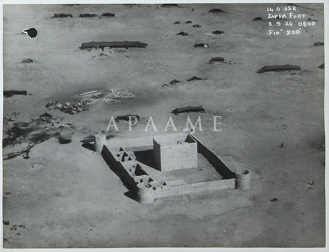
What a difference 86 years can make. Qa' al Jafr, located c. 50km ENE of Ma'an in Jordan looked the picture of health in 1926 when the Royal Air Force flew over and took this magnificent photograph. A large number of bedouin tents and a small heard of camels can be seen in the landscape, dwarfed by the imposing unfinished 'palace'. The structure was built by Turkish prisoners of war under Auda Abu Tayi, a leader of the Great Arab Revolt who had settled in the region. The location took advantage of a nearby well. The structure, probably inspired by Roman, Crusader and Islamic forts, remained unfinished after his death in 1924.

Qa' al Jafr fort
Remains of Qa 'al Jafr Fort September 1926. Photograph: The National Archives, London.

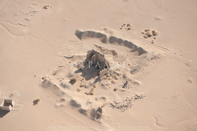
Today: the outer walls are almost completely invisible and the central enclosure is crumbling rapidly. The ruinous state is surprising considering its relatively young age (under 100 years), but is also a reminder of how the physical remains of the past, even if belonging to a recent era, can decay.

Jafr Fort
Remains of Qa' al Jafr Fort, October 2011. APAAME_20111013_DLK-0228. Photographer: David Kennedy.

Tuesday, 9 August 2011

The Harret al-Shaam and aerial reconnaissance


Approximate extent of the Harret al-Shaam. Drawn by Mat Dalton.

The Harret al-Shaam is the most northerly of the basalt lavafields that mark the Arabian landscape from Syria in the north, down the western side of the Arabian Peninsula to Yemen in the South. The Harrat Ash-Sham, which itself stretches from Syria through Jordan and into Saudi Arabia, was first noted to contain remarkable stone structures visible from the air by the RAF pilots that flew across it on the airmail route from Cairo to Baghdad.

It is only recently that a more systematic aerial survey of the Harrat over Jordan has been started (Kennedy, D. L., Bewley, R. H., 2009. Aerial Archaeology in Jordan. Antiquity. 83, 69–81) but most countries in the greater Arabia area will not allow aerial reconnaissance or provide aerial imagery. Virtual globes such as Google Earth however provide accessible high resolution satellite imagery for sections of this expansive archaeological landscape which are being continually updated.

The original known distribution of the stone structures first captured in the lenses of RAF pilots, thought to be only located in the basalt lavafields of Jordan, has now been expanded dramatically. Google Earth has allowed for the number of Kites identified on the Harrat ash-Sham alone to increase dramatically - the most recent count (early 2011) was for c. 1600 Kites.
Distribution of the principle lava-fields. Drawn by Stafford Smith.