Monday 15 December 2014

Research: Robert Alexander MacLean

Amongst the pioneers of Aerial Archaeology – albeit on a peripheral level, is this enigmatic character.

The American Journal of Archaeology for January-March 1923 published the abstracts of lectures given the previous December at the annual conference of the Archaeological Institute of America (AIA). One abstract is entitled “The Aeroplane and archaeology”, the author a professor at University of Rochester in New York State. Sadly, never published and tantalizing because of what MacLean had to say:
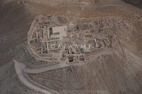
“Among the many services which the aeroplane is rendering at the present time not the least is the aid which it is giving in archaeological discovery. In countries such as Mesopotamia where there are few maps to guide the archaeologist, and in portions of Arabia which are difficult of access by ordinary means of travel, the aeroplane has already proved to be a valuable subsidiary help in making preliminary surveys, and in locating historical ruins and the possible sites of ancient cities. Two illustrations will suffice. This last summer I went by aeroplane from Amman in Transjordania to visit some Roman ruins at ‘Kasr Azraq’ in the Syrian desert. … Another noteworthy feature was the presence on the oasis of about twenty pools of clear cold water surrounded by a Roman wall. It was interesting to observe that while this wall, only portions of which remain, could hardly be distinguished by an observer on the ground, its alignment and complete circuit of the pools could be seen clearly from the air.

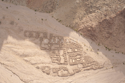
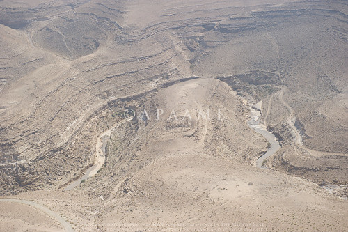
My second illustration is from Mesopotamia. Among the many lost cities of ancient times may be mentioned two which Xenophon speaks of in the Anabasis …. Until quite recently the difficulty in determining the site of these two cities was due to the fact that the course of the Tigris in ancient times was not known to us. But by recent observations and photographs taken from the air it is now pretty well established that that portion of the Tigris which lies to the east of Xenophon's Median Wall had its bed about fifteen miles to the west of the present bed of the river. The depression seen from the air and the line of mounds along the depression were the clues which led to what is thought to be the discovery of the sites of both Opis and Sittace.”

Quite apart from what MacLean is ‘discovering’ from the air and what other aerial photographs he may have had, is the puzzle about how he came to be in a position to fly over these places at all, especially in the case of Azraq which was the specific object of the flight.
Qasr el-Azraq
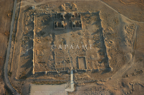
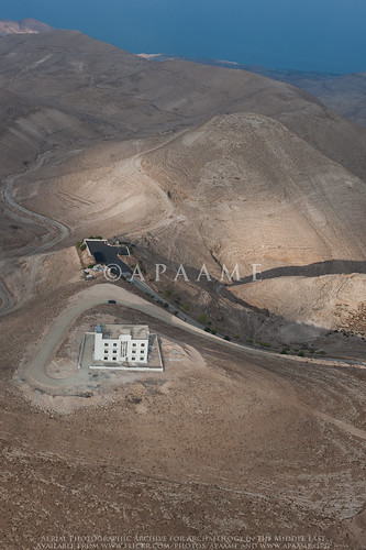
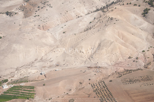
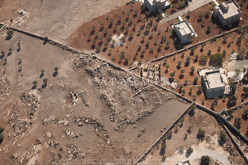
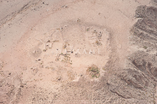
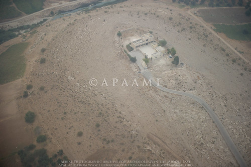
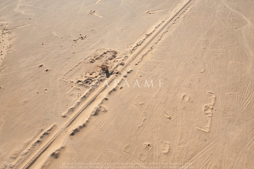
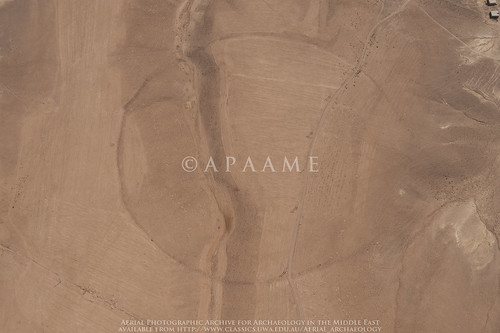
Qasr el-Azraq today. APAAME_20080909_IAR-0205.
MacLean is an intriguing character and deserving of a fuller treatment which can to some extent be done thanks to a large number of small snippets of information available elsewhere. Here it is just possible to sketch a few details relevant to Aerial Archaeology at what is a very early date for such work in the Middle East – Poidebard only arrived in Syria to begin his flying programme in 1925.

MacLean, the son of Scottish immigrants to Canada, is said to have been:
“… teaching at the University of Manitoba when World War One broke out. He enlisted immediately, in August, 1914, in the Winnipeg Grenadiers and landed in England with the first Canadian contingent in October of that year. He was commissioned as an officer in the British Imperial Army in January, 1915, and served in France for eight months. In 1916 he was sent to the Middle East where he served in various capacities and in various countries - Mesopotamia, Persia, Arabia, and India. For the last year of the war he was engaged in political work, coming into contact with such personalities as Gertrude Bell, H. St. John Philby, Sir Percy Cox, and Col. T. E. Lawrence.”

He is described as having “served as staff captain under General Maude, being engaged particularly in intelligence and political work” and elsewhere he said he “arrived in Bagdad with the British army on 11 March 1917”. MacLean was soon moved westwards and is described as having been a “member of General Allenby’s staff when the British army marched on Jerusalem”.

In the magazine of his university he recounts the flight of 1922 which evidently included the flight to Azraq. Although he does not say so, he was evidently flying across Jordan and Iraq in one of the RAF aircraft of the newly developed Airmail Route from Egypt to Basra, initiated in June-July 1921. The few passengers carried were normally only service or important government personnel, implying MacLean had some influence.

MacLean explains he was in Baghdad as part of the celebration marking the laying of the foundation stone of the University of Baghdad and that he also met King Feisal. Returning west, his aeroplane had engine trouble and they had to land and spend a night in the desert.

There is much more one may add but two salient points to note are that MacLean is untraceable in the records of those who have spent many years researching military intelligence in the Middle East during the First World War. On the other hand, if he was – like that other oddity in the region, Richard Meinerzhagen, a fantasist, he nevertheless seems to have known enough people of influence to be given a flight to Azraq, taken on two trips on the new Airmail Route, perhaps also flown by the RAF in Iraq and supplied with some aerial photos for his lecture.

Sadly, one avenue of research is closed. MacLean’s sole child, a son, is long dead and had been estranged from his father for many years; the son’s children, brought up in France and French citizens, came to me for information about their grandfather.

But there must be some record of his First World War service and perhaps how that led to his flights in 1922. Perhaps he really did know Bell, Philby, Cox and Lawrence. In 1922 the senior British Political Officer in what they still called Transjordania was … Harry Philby. Shortly after MacLean flew across Jordan, Meinerzhagen crossed it on the ground. At the far end of the route, MacLean would have found the British residents of Baghdad included both Gertrude Bell (Oriental Secretary) and Sir Percy Cox (High Commissioner for Iraq).

Many of the personal details of MacLean’s long life and career have been traced as have his publications (including two books published privately). The gap is his military service.

– David Kennedy

Friday 21 November 2014

Flying 2014 - New sites photographed

The 2014 AAJ flying season is well and truly behind us, the photograph cataloguing completed, and we can now start to really look and analyse what we have captured.

We have often been asked “When will the Aerial Archaeology in Jordan project be finished?”. Despite flying annually in Jordan since 1997, AAJ is far from finished; it is a long-term programme and unique in the region. It has been a series of voyages of discovery as we find new sites every year and we record changes in the landscape, as well as working with other archaeologists in the region, who request aerial reconnaissance over their site or area.

In 2014 we covered a huge area of Jordan, north-south, east-west (limited only by the range of the helicopter or the borders of neighbouring countries).

Our flights are usually predetermined by a list of sites that we have identified (partially thanks to the input of many colleagues working in Jordan) as needing new photography or that have not been photographed before. Flying between these sites we often catch glimpses of other sites, and occasionally these turn out to be something new too! We do an initial check of these ‘new’ sites against historical maps (such as the K737 series 1:50,000 maps) and the MEGA-Jordan database to try and identify the sites. Occasionally, a new site for us appears to be a new discovery- such as the possible Roman Column Quarry from Flight 20141013, which is always exciting and is just the start of a process of investigation and research.

Here is a taste of what is new in our database from this year’s flying:

Two sites near Zarqa we couldn’t believe we hadn’t photographed before were Jneneh and Kh. al-Batrawy.
Khirbet al-Batrawy
Khirbet al-Batrawy - © APAAME_20141012_RHB-0034. Photographer: Robert Bewley.
Udhma, north of Amman, has half been destroyed by modern development.
Udhma
Udhma - © APAAME_20141012_MND-0096. Photographer: Matthew Dalton.
Tells of the Jordan Valley – Tell el Qos, Ammata, Hammeh, and Tall Abu ez Zeighan, also, new excavations at Tell el-Hammam.
Tell el-Hammam; Kafrein Trenches 2
Tell el-Hammam - © APAAME_20141028_DLK-0365. Photographer: David Kennedy.
Nearby up the wadi from the Kafrein Dam is the site of Suwwan.
Suwwan
Suwwan - ©APAAME_20141028_DLK-0386. Photographer: David Kennedy.
Sometimes sites can be overlooked because of their vicinity to a ‘big name’ site, but we do not want to be guilty of this mistake. Sites in the vicinity of MachaerusAtaruz, Aruda, Khirbat ed Deir and El-Quraiyat, and Umm er-ResasUmm er-Resas Ruin 1 and 2, were additions this year.
Ataruz (Attarus)
Ataruz - © APAAME_20141013_REB-0051. Photographer: Rebecca Banks.
A rare foray to the Southern Dead Sea Basin captured many sites previously not photographed by us. A highlight included the Wadi Hamarash excavations suggested to us by Prof. Adamantios Sampson, not least because of what an interesting squeeze it was for the Helicopter in the Wadi valley.
Wadi Hamarash Neolithic Site (Site 1)
Wadi Hamarash Neolithic Site (Site 1) - © APAAME_20141013_REB-0286. Photographer: Rebecca Banks.
Mtakalash ar-Rababa, an interesting site which was snapped just in passing.
Mtakalash ar-Rababa
Mtakalash ar-Rababa - © APAAME_20141013_MND-0507. Photographer: Matthew Dalton.
We also photographed the shelter for Deir Ain Abata being erected over the site.
Deir Ain Abata
Deir Ain Abata - © APAAME_20141013_REB-0333. Photographer: Rebecca Banks.
Flying to and from Marka Airport in Amman over the fertile hinterland is always a busy time with sites numerous and close together- sites are often just photographed ‘in passing’. This year the keen eyes of Mat spied what appears to be a possible Tomb (Amman Tomb 5), and a large concentration of rubble underneath an olive plantation that is likely a settlement or village of some description (Amman Village? 1). Neither site is recorded in MEGA-Jordan or on the K737 maps, but the village is clearly visible on Hunting Aerial Survey photographs of 1953 taken before the olive grove existed. A revisit on the 6th and last flight has confirmed both sites are indeed of interest.
Amman Village? 1
Building rubble and cistern evident at site 'Amman Village? 1'. © APAAME_20141028_DLK-0282. Photographer: David Kennedy.
Our flight to Aqaba was a very productive two days as we rarely get to fly so far south. Despite delays and difficulties caused by the weather many sites were photographed for the first time, some highlights included:

Kh. Titn sites recommended to us by Kristoffer Damgaard.
Kh. Titn 2 (Large Cluster)
Kh. Titn 2 (Large Cluster) - © APAAME_20141020_RHB-0069. Photographer: Robert Bewley.
The keen eyes of Don Boyer through poor visibility alerted us to the existence of Mlehleb.
Mlehleb
Mlehleb - © APAAME_20141019_DDB-0006. Photographer: Don Boyer.
The amazing fort ‘Aina Fort 1’, (edit: thank you to Haim Ben David for information regarding this site - it is identified as el-Medeiyneh by Glueck (1935, 104-1-6, 181)) and a smaller fort ‘Tafila Fortlet 1’.
Tafila Fortlet? 1
'Tafila Fortlet? 1' - © APAAME_20141019_DDB-0244. Photographer: Don Boyer.
The ancient site underneath the modern town of Buseira (Busayra) suggested to us by a University of California, Berkeley, team.
Buseira
Buseira (Busayra) - © APAAME_20141019_RHB-0256. Photographer: Robert Bewley.
Railway enthusiasts should enjoy this year's flying along the southern portion of the Hedjaz Railway in Jordan.
Mahattat er-Ramla
Mahattat er-Ramla on the Hedjaz Railway. © APAAME_20141020_DLK-0221. Photographer: David Kennedy.
Particularly striking were the Ottoman defensive structures positioned at strategic points along its length.
Mudawwara Northern Redoubt
Mudawwarra Northern Redoubt - © APAAME_20141020_DDB-0164. Photographer: Don Boyer.
A treat for Romanist David Kennedy was the Roman Fort at Gharandal, and the long stretch of the Via Nova Traiana investigated (see blog - The Via Nova Traiana in Central Jordan), but also the unexpected traces of Roman Roads photographed in passing.
Umm er-Resas Roman Road 1
A stretch of possible Roman Road near Umm er-Resas. © APAAME_20141013_MND-0244. Photographer: Matthew Dalton.
Research into the site of Muwaqqar by David Kennedy led us to investigate possible sites ‘Sahab Ruin 9 and 10’ located nearby which were identified from satellite imagery. Neither site is recorded in MEGA-Jordan or on older maps to our knowledge, but the photographs show they are possibly substantive sites.
Sahab Ruin 10
'Sahab Ruin 10' - © APAAME_20141028_TPH-0125. Photographer: Travis Hearn.
These photographs are a record of these sites, but also a starting point or addition to the research into the many periods of history, heritage and archaeology in Jordan. Please feel free to leave comments on the Flickr image pages regarding site identification and information.

We owe a debt of gratitude to so many but without our funders, especially The Packard Humanities Institute and the Seven Pillars of Wisdom Trust, we would not be able to continue. We are very grateful to our hosts the Council for British Research in the Levant (CBRL) in Amman, and especially Nadja. The Royal Jordanian Air Force and their superb pilots ‘make it happen’ and could not be more helpful, hospitable and safe. David, Bob, Becc, Mat, Travis and Don all made this an exceptional year and we hope for many more.

You can find all of the 2014 Flying Season photographs on our Flickr '2014 Flights' collection page: https://www.flickr.com/photos/apaame/collections/72157646490200724/

Monday 10 November 2014

Research: Pioneers - On a further personal note …

In a recent post on Insall, one of the three RAF pioneers in aerial reconnaissance over the Airmail Route and one of the first to publish an aerial photo of a Kite, I noted that a decade later he was the Station Commander of RAF Abu Sueir in Egypt where my father completed his flying training in 1936. I had long regretted that my father’s training at a Middle East base which was explicitly intended to produce pilots for service in the East, saw him posted to India for several years. Three of the other new pilots were posted to Iraq and one to No. 14(B) Squadron at Amman (killed shortly after in an accident).

In is now clear that although my father was never stationed in Iraq and Transjordan, he twice flew along the Airmail Route in those two Mandates. Putting together a few brief entries in his logbook, a handful of small photos and a postcard he sent to his brother-in-law back on the Northwest Frontier of British India, the episode is definable.
The 'Flying Boat' 'AWARUA'
About 17 July 1939 he was sent to Heliopolis in Egypt to collect and ferry back to India, one of the new Blenheim light bombers with which the RAF was being re-equipped. He recorded the flight on an Imperial Airways flying boat from Karachi via the Gulf and Habbaniya in Iraq to Tiberias on the Sea of Galilee and finally Alexandria – a two day journey. A few photos of the flying boat and a postcard from Tiberias:

Postcard from Tiberius.
I am having a marvellous time on board this flying boat ‘AWARUA’. We have just had Tiffin at Tiberias on Sea of Galilee.

By chance, that same flying boat was transferred the very next month to service in Australasia with Tasman Empire Airways Ltd (TEAL) on its NZ to Sydney route. As it happens there is a contemporary account now online of that delivery flight including:
Rapid refuel and then off towards Palestine where we land on the Sea of Galilee at Tiberius (sic), and here the skipper fills a special bottle with Galilee water to take to New Zealand for the christening of his new baby.
From Tiberius (sic) until we pass down into the Persian Gulf this next stretch is invariably hot and bumpy and the pipe line desert below never looks inviting especially when in a flying boat, …

My father’s logbook records his own flight back to India in August 1939, piloting his Blenheim:
5 August: Heliopolis – Habbaniya
5 August: Habbaniya – Shaibah
6 August: Shaibah – Sharjah
6 August: Sharjah – Karachi

That first stretch of 4 hours on 5th August would have largely retraced the Imperial Airways route across the Jordanian panhandle following the track alongside the oil pipeline which seems to have replaced the initial RAF track around the southern edge of the Harret ash-Shaam lavafield. Sadly he took no photos – almost 60 years before my own first flights in the same area.

- DLK

Friday 31 October 2014

Research - Jordan 'Big Circles' Publicity

We are receiving a lot of hits and publicity from the Owen Jarus 'Ancient Stone Circles in Mideast Baffle Archaeologists' article published on LiveScience yesterday (30 Oct. 2014). 

DailyMail Online have also followed up with their article 'Mystery of Jordan's Big Circles: Ancient Stone Rings in the Desert have left archaeologists baffled' (Victoria Woollaston, 30 Oct. 2014).

If you are interested in accessing the original article by Prof. David Kennedy in Zeitschrift für Orient-Archäologie 6 please see our blog for publication details: Publications: Remote Sensing and ‘Big Circles’ A New Type of Prehistoric Site in Jordan and Syria 

The Syrian 'Big Circle' was discovered and investigated by Graham Phillip and Jennie Bradbury and published in the journal Levant, you can access their article through Maney Online: 'Pre-Classical Activity in the Basalt Landscape of the Homs Region, Syria: Implications for the Development of 'Sub-Optimal' Zones in the Levant During the Chalcolithic-Early Bronze Age'.

If you are interested in seeing more photographs taken in the course of our investigation of the structures on the ground and from the air, please visit our Flickr page and search for 'Big Circle'.

Circle 6
Jordan Big Circle 6. © APAAME_20090930_DLK-0263.

Fortnight of Firsts - Flight 20141028


I was very fortunate to be invited to join the Aerial Archaeology in Jordan 2014 flying programme this year. It has been a fortnight of ‘firsts’ for me. My first visit to Jordan, first visit to a Roman site, and a my first time in a helicopter – something I am particularly proud of as one who is terrified of flying, even on commercial aeroplanes. Taking photos from the open-door side of a Huey was not something I imagined I would be able to do.

As the helicopter rose up out of Marka Air Force Base, and the view of Amman began to unfold before our eyes, my fear turned to fascination and excitement. The bird’s eye view, whether of a modern city or an archaeological site, gives a unique perspective on the connexion between the various different elements that together make up those larger networks we usually only ever see from ground level.


View of Amman © APAAME_20141028_TPH-0004

Trying to espy a site from above and then photograph it was a very rewarding experience. Undertaking the flight only increased the respect I have for the dedication David Kennedy and Robert Bewley have for recording as much of Jordan’s immense and varied archaeological treasures as they have thus far been able. No doubt this respect and gratitude is a sentiment that future generations, especially Jordanians, will share.

Of the sites we photographed two were particularly memorable for me – the recently spotted, possibly Roman, quarry with columns, under threat of being consumed by the adjacent modern quarry and Qasr el-Maduna, an imposing desert castle.

Sahab Quarry © APAAME_20141028_TPH-0010


Qasr el-Maduna © APAAME_20141028_TPH-0069

While much work goes on behind the scenes, including cataloguing photos and making them available through our Flickr page, I have also had time for a visit to Gerasa (Jerash), Azraq Oasis, and, this morning, a ground visit to an endangered Roman town, Yajuz, just outside of Amman – this is one example, yet certainly much of Jordan’s heritage is under threat. 

I have thoroughly enjoyed joining the team in Jordan, my time in Amman has been made pleasurable and stress-free thanks to the support of APAAME, the BIA (British Institute in Amman) and the Jordanians I have had the pleasure to meet with, all of whom are wonderful ambassadors for their country – much good could come of tourism to Jordan’s remarkable historical sites. As Jordan faces various challenges, hopefully the opportunities to preserve (and market) its heritage are not lost.


Wednesday 29 October 2014

Flight 20141028: Endangered Archaeology – Yajuz

Yajuz in 1998. © APAAME_19980517_DLK-0031.
Yajuz is a small town of the Roman period lying about 10 km (sld) from the centre of Roman Philadelphia (Amman). Excavation has revealed three churches with mosaic pavements, several major residential buildings, an area with major wine presses and a large tomb nearby. The full extent is unclear but is probably 15-20 hectares. A major settlement in the hinterland of Philadelphia, probably one of several but unusual in that it has not been overlain by the expansion of Amman.

The Roman highway from Philadelphia to Gerasa (Jarash) passes by its eastern fringe (Blue). The road has been well-known for over a century and numerous milestones have been recorded. The first stage of about 10 Roman miles is now hard to trace amongst the rapid recent sprawl of Amman and many of the milestones have been broken up, buried or pushed away by development. Yajuz itself seemed safe, protected by its status as a site excavated extensively over many years and marked by boards set up by the Department of Antiquities of Jordan.
Google Earth screen capture of Yajuz site with areas of interest indicated.
In the last decade that status has come under threat as massive new housing projects have sprung up all around, major highways have sliced past making it an attractive commuter suburb and the price of land has continued to soar. APAAME’s flying programme – Aerial Archaeology in Jordan, has regularly monitored the site, a task made easier by its proximity to a regular route for us returning to the airfield at Marka. In 2010 we singled the site out as a place that deserved special protection and development as a tourist destination (Kennedy and Bewley 2010: 199-201).
New Apartment blocks at 'A'. © APAAME_20141029_DLK-0503.
Houses at SE corner of Yajuz at 'B'. © APAAME_20130414_RHB-0468.

It is clear the site is being slowly but steadily eaten away by development. The blue-roofed building which had already intruded into the site over a decade ago has now – since April 2013, been joined by a two large blocks of apartments (A). At the southeast corner two houses were cut into the site several years ago (B). Now another house is being constructed cutting into the north edge (C).

House in North of site at 'C'. © APAAME_20141029_DLK-0512.
Unless steps are taken immediately, Yajuz will join the catalogue of other small towns around Philadelphia, still notable ruins in the 19th and early 20th century which are now largely lost. 


- David Kennedy

Kennedy & Bewley (2010) 'Archives and Aerial Imagery in Jordan', in Cowley, Standring and Abicht (Eds) Landscapes through the Lens, Oxford: 193-206.


Saturday 25 October 2014

Filming in Azraq

Friday 24th October. Up before sunrise, left Amman with a film crew and headed east to Azraq.

David Kennedy on the Umayyad reservoir wall - Azraq Wetland Reserve.
The day began with some shooting at Azraq Wetland Reserve. While there we took the opportunity to photograph the Umayyad reservoir wall. Sadly the oasis has greatly diminished in size in the last twenty years. Despite the Water authority pumping 1.5 to 2.5 million cubic metres of water into the wetlands each year, it is not enough to replenish the excessive pumping of water out of the oasis and, sadly, it is still shrinking in size.

Filming at Azraq Wheel 82
From there we headed out into the basalt desert to visit a Wheel and a Kite. We drove as far as the 4WD could take us across the mudflats, from there a somewhat arduous trek across the volcanic rocks to the site of interest. Even in this rather remote location we saw signs of recent looting – a bucket and pick axe inside the Wheel!


Looter's tools - Azraq Wheel 82
As one can see from the ground photo above, these stone structures don’t look very impressive, if they are noticed at all, when on foot. However, when seen from above, through aerial photography or satellite imagery, a very different picture emerges.
Azraq Wheel Group B. © APAAME_19970527_DLK-0157
Azraq Kite 81, Wheels 191, 192, 193. ©APAAME_20120522_DLK-0589
Returning to the Azraq Lodge (converted former British military hospital) in the evening for some final recording before heading back to Amman for a well earned dinner. 

Friday 24 October 2014

Flights 20141012-13 - Blink and you will miss it

One of the main aims of the Aerial Archaeology in Jordan Project is to photographically record archaeology in Jordan – a record through which it can be monitored.

This year has provided some highs and lows.

Reconstruction work has occurred at Qasr el-Mshatta near Queen Alia International Airport.
Qasr el-Mshatta
Qasr el-Mshatta in 1998. © APAAME_19980513_RHB-0054.
Qasr el-Mshatta
Qasr el-Mshatta in 2014. © APAAME_20141013_RHB-0012.

A possible Roman column quarry has somehow survived (so far) amongst a massive modern limestone quarry – and a ground visit found another quarry site on an adjacent hill. But how long will they survive the expanding modern quarry?

Sahab Quarry 1
Quarry. © APAAME_20141013_RHB-0467.
Two of the original columns of Machaerus have been restored and inaccurate representations removed.
Machaerus
Machaerus in 2006. © APAAME_20060910_DLK-0005.
Machaerus
Machaerus in 2014. © APAAME_20141013_MND-0086.
The building of a pilgrim hotel has destroyed one of the Roman siege camps (Roman Camp P) surrounding the site of Machaerus. The location no doubt was chosen for its excellent view over the ancient site. It is likely that very reason had once made it the ideal location from which the commander of the Roman siege forces possibly directed his assault.

Machaerus
 Machaerus in 1998. The faint trace of Roman Camp P can be seen on the peak in middle ground right. © APAAME_19980517_RHB-0071.
Machaerus
Pilgrim Hotel in foreground of Machaerus in 2014. © APAAME_20141013_RHB-0032.
Necropoli have been the target of looters since Antiquity, but modern looting is also evident – individual shafts at Khirbet Ain, honeycombing of hillsides at Pella and the systematic looting of Dead Sea sites Fifi, Al-Nage’a and Bab edh-Dhra.

Kh Ain Cemetery
Looting shafts at Khirbet Ain. © APAAME_20141012_REB-0235.
Pella
Looting shafts in the hillsides around Pella. © APAAME_20141012_MND-0384.
Fifi Cemetery
Systematic looting of Fifi. © APAAME_20141013_REB-0277.