Monday 24 December 2012

Slides of Syria

As the year comes to a close, it is inevitable that we reflect on what we have done and what has been happening in the world.

I have been scanning slides from the late 1970s… a lot of slides, of archaeological sites in the Middle East. Most were taken by David K at a time when sites were often in better condition or not yet overgrown by developing villages and towns, so archaeological artefacts in their own right.

While scanning these slides I continually came across evidence of the beautiful archaeological record of Syria, and in the news I daily come across reports of conflict that increasingly and unavoidably is affecting these archaeological sites, whether they are caught in the crossfire or directly targeted by looting.

So, I thought it best to share some of these digitised slides with you and take you to sites that we may not be able to protect now, or visit in the near future, but of which we can hope to preserve evidence and knowledge.

(In no particular order... Please click on an image to enlarge it.)
Basilica, Deir Semaan.
South west church, Deir Semaan.


Deir Semaan (Saint Symeon Monastery or Telanissos) is one of many ruined villages, known collectively as the 'Dead Cities' on the limestone massif west of Aleppo in Syria’s north. These late Roman villages are extraordinarily well preserved, buildings sometimes surviving to two and three stories high, and allowing a superb insight into late Roman town life. These magnificent ruins however have suffered in the crossfire, and also through looting. This short article on the research of Emma Cunliffe, Durham University, includes a witness’s video recording damage to one of these sites, and reports have emerged that the Monastery of Saint Symeon has been damaged by shelling. Link.
Temple of Nebo in foreground with the great temenos of the Temple of Bel in background, Palmyra.
Palmyra is one of the best-known ancient sites in Syria. The city flourished due to its profitable position between the west and east, and became a major Roman city in the 2nd and 3rd centuries AD. Built around an oasis in the middle of the desert, the grandeur and preservation of the site is all the more marked due to its isolation, and it has been a favourite of tourists since the 19th century. A report on the Global Heritage Fund blog details how the site has become caught in the crossfire and is a target for looting. http://globalheritagefund.org/onthewire/blog/palmyras_ruins.
West wall of Halebiyeh looking east from the citadel towards the Euphrates River.
Halebiyeh, or Zenobia, is located on the banks of the Euphrates. The walls extending out from the Citadel of an immense Late Roman fortress city are the most prominent feature of this beautifully preserved site. The astonishing scale and quality of preservation can be gauged by noting David’s white LWB Landover (inside of the city wall in the centre of picture) (cf. D. L. Kennedy and D. N. Riley, Rome’s Desert Frontier from the Air, London (Batsford)).

Section C3 of Dura Europos.
Palmyra gate, Dura Europos.


Dura Europos, also on the banks of the Euphrates River, was preserved in sand until its excavation during the interwar period, prompted by the discovery of remarkably preserved frescos. Even more important was the discovery of a huge cache of papyri which included the largest single collection of papyri for the Roman army anywhere in the Empire, including Egypt.
The Tetrapylon at Damascus, located at one end of Souk al-Hamidiyeh to the west of the Umayyad Mosque in the city centre.
Damascus is the ancient and modern capital of the region and where the archaeological record is hidden in side streets, built into houses, and walked through as part of daily life in a thriving city. As fighting intensifies closer to the ancient city (BBC news article: http://www.bbc.co.uk/news/magazine-20659573) how will the ancient walled city and 1400 year old Umayyad Mosque built over the immense church of St John fare if it breaks through to the heart? The once lively Souks and are now devoid of tourists and suffer from intensifying security raids. One hopes the beautiful Souk al-Hamidiyeh and the numerous early medieval houses tucked in side streets will not suffer the same fate as the ancient heritage listed market place of the city of Aleppo, the Souk al-Madina, which was irreparably damaged in September– see http://www.reuters.com/article/2012/09/30/us-syria-crisis-idUSBRE88J0X720120930
General view (north) of Bostra.
Bostra is in the south of Syria in a region known as the Hauran – a fertile semi-arid landscape on the edge of ancient lava-flows. It was the northern-most city of the Nabataean kingdom that stretched down through its capital at Petra into north-western Saudi Arabia. Nabataea was incorporated into the Roman Empire with Bostra as the capital of the new province of Arabia under Trajan in AD 106. The site is perhaps best known for its Roman theatre built from black basalt rock, but the ruins of the ancient city are also well preserved amongst the streets of the modern town, with towers in some cases standing over two stories high. The town has been damaged by shelling this year.

All photographs are © David L. Kennedy and belong to the Aerial Photographic Archive for Archaeology in the Middle East. After the slide collection is catalogued it will be available online at our Flickr archive: link.

I would like to thank David for looking over this blog, and for his continual remarks and encouragement while I develop the APAAME digital collection. Any remaining errors are wholly my own.
-Rebecca Banks 

Links:
Aryn Baker & Majdal Anjar, Syria’s Looted Past: how ancient artefacts are being traded for guns, Time World Sept 12 2012.
http://world.time.com/2012/09/12/syrias-looted-past-how-ancient-artifacts-are-being-traded-for-guns/
Emma Cunliffe’s updates on the Global Heritage Network blog site, one of the latest, which contains links to video footage, is the following:
Emma Cunliffe, No World Heritage Site Safe in Syria, Global Heritage Network Blog, Nov 19 2012.
http://globalheritagenetwork.ning.com/profiles/blogs/no-world-heritage-site-safe-in-syria#_edn16

Tuesday 18 December 2012

Publications - Historical Aerial Imagery in Jordan and the Wider Middle East

Hot off the press!
Robert Bewley and David L. Kennedy, 2013, 'Historical Aerial Imagery in Jordan and the Wider Middle East' pp. 221-242 in: William S. Hanson and Iona A. Oltean (eds) Archaeology from Historical Aerial and Satellite Archives, Springer: New York/Heidelberg/Dordrecht/London.
ISBN: 978-1-4614-4504-3

The book or eBook can be purchased from the Springer website: http://www.springer.com/social+sciences/anthropology+%26+archaeology/book/978-1-4614-4504-3

Friday 14 December 2012

Publications- Bulletins


Bit of a catch up on some bulletins from the last few months:


Bob Bewley with David Kennedy, Mat Dalton & Rebecca Banks, 'Aerial Archaeology in Jordan: 2010-2012', Aerial Archaeology Research Group News, Vol. 45, September 2012: 74-81.
Available to members from their website.

Fiona Baker & David L. Kennedy 'Jarash Hinterland Survey' in: Keller, Porter & Tuttle, 'Newsletter: Archaeology in Jordan, 2010 and 2011 Seasons', American Journal of Archaeology, Vol. 116, No. 4, October 2012: 702-703.
Bulletin of the Council for British Research in the Levant logo
David Kennedy & Bob Bewley, 'The Harret al-Shaam, from Air and Space' in: 'Long-term Landscape Environment and Climate Change Studies, from the Past through to Predictive Models for  Future Developments', Bulletin of the Council for British Research in the Levant, Vol. 7, No. 1, October 2012: 60-62.
Available through IngentaConnect.

Publications - APAAME photo in December issue Antiquity

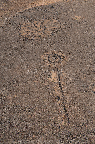
Safawi Pendant 52, Safawi Wheel 290
APAAME_20120522_DLK-0096. Photograph: David L. Kennedy
Featuring in the latest issue of Antiquity is this photograph taken by David Kennedy on the 22 May 2012 during our last season of flying in Jordan. You can read more about the photograph and its features in the journal's Editorial:
Editorial, Antiquity, Vol 86 No 334 December 2012: 966. http://antiquity.ac.uk/journal.html#editorial

Wednesday 5 December 2012

Workshop - GIS and Near Eastern Archaeology

A Methodology for the Future? The role of GIS technologies within 21st century Near Eastern Archaeology

CBRL November 30th to December 2nd 2012 at the CBRL Institute in Amman, Jordan.


Congratulations to all the organisers of this intimate, perfectly formed workshop as it brought together a small but interested (and interesting) grouping.
An interesting group of workshop attendees - British Institute Director Carol Palmer (front far right); workshop organiser Jennie Bradbury of Durham University (front left of middle); and the author of this blog Bob Bewley (front centre) (Photograph: BI Amman Facebook page).
There were 22 people from wide range of places and backgrounds – a small group but a very useful event for two reasons. The first is the opportunity to share ideas, understand each other’s needs and work on ways of better and more useful collaboration.  For the APAAME project this will involve a closer working relationship between the MEGA-J (national online archaeological database for Jordan) and ourselves.

The second was a more general one of meeting and talking to people who one either wanted to talk to but never managed to find the time, or people one didn’t know and was glad to meet. The ‘regional’ nature of the archaeology was highlighted by the use of GIS – showing the longer terms trends when the masses of data are analysed to show the changing distribution patterns; be it in the prehistoric Roman or medieval periods.