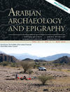
The November 2015 Special Issue of 'Arabian Archaeology and Epigraphy' Desert Kites - Old Structures, New Research contains a paper on this project's research into the Kites in Saudi Arabia conducted by David Kennedy, Rebecca Banks and Matthew Dalton. The paper specifically focuses on the case study area of Harret Khaybar.
The collection of papers is the result of a stimulating workshop on Kites organised by Dr. Ueli Brunner and held at ICAANE IX in Basel, Switzerland (See blogs: May 2, 2014, and June 23, 2014).
David Kennedy, Rebecca Banks & Matthew Dalton
Kites in Saudi Arabia
Arabian Archaeology and Epigraphy Vol. 26 iss. 2
Pages 177-195
DOI: 10.1111/aae.12053
The paper can be accessed through Wiley Online Library.
Showing posts with label Satellite Imagery. Show all posts
Friday, 23 October 2015
Publications: Kites in Saudi Arabia
Labels:
Kites,
KSA,
Publications,
Remote Sensing,
Satellite Imagery,
Saudi Arabia
Sunday, 13 July 2014
Research: Remote Sensing, Kites and Agriculture
This blog was originally posted as part of the 'Day of Archaeology' 2014 (11 July 2014). You can find all posts, and information, on their website: http://www.dayofarchaeology.com.
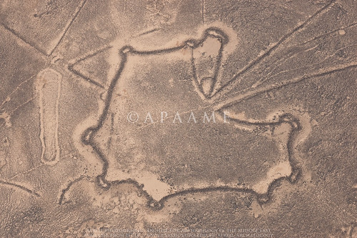
As you may have gathered from the many photographs we have taken in the Jordanian harra (see our Flickr archive), Kites in Jordan are found predominantly on the basalt lavafield. Due to the sharp contrast between the black rock and yellow sands these are often easily discernible in good resolution satellite imagery and even more so in the course of aerial photography conducted each year by the Aerial Archaeology in Jordan project (AAJ). Due to improved availability of good resolution satellite imagery over the Jordanian harra I recently embarked on a review of known features over the landscape in preparation for our upcoming field season in October. Due to the reasons mentioned, the majority of the harra was scrolled over relatively easily on my desktop, but it was not all a walk in the park.
The north western section of the harra was altogether more difficult to review. Our knowledge of site distribution in this area began with those traced on the 1:50,000 K737 maps. This was improved upon through an analysis of the Hunting Aerial Survey photographs undertaken by Prof. David Kennedy in the RSAME project where the information gathered from the aerial survey photographs were transcribed onto acetate copies of the 1:50,000 map sheets. Many of these sites were reviewed through ground survey conducted in the Southern Hauran Survey Project (SHS) in the late 80s and into the 90s, and included a few Kites, and AAJ, beginning in 1997, has also flown over and documented many sites in the region.
Google Earth (GE) has allowed us to utilise an affordable platform through which to easily review sites identified and photographed by the project, as well as investigate new sites for future research and documentation. In its early years the remote areas of Jordan were not a particularly high priority for high resolution imagery however, and many site locations were transferred into GE based on what was originally mapped in the earlier surveys mentioned, or locations estimated from the flight track log of AAJ aerial reconnaissance. These sites were therefore in need of the review I was conducting in order to increase the accuracy of the site location we had recorded, but also to verify whether the site first identified from earlier surveys was indeed correct.
The four map squares in question - Quttein, Hibabiya, Hallabat and Jimal are now in high resolution in GE - a victory you would think that would make life easier, but no. Here the basalt is no longer a deep dark black that contrasts easily for identification, but its age has bleached it and in some cases developed a patina over the surface so that it resembles the colour of the landscape around it. Take satellite imagery in the middle of the day and what you have is a bleached out landscape where you are lucky to identify anything at all. Moreover - this area is increasingly being utilised for agriculture and many sites identified from imagery taken in 1953 are now underneath fields of green. My standard approach of panning back and forth in GE and verifying against our aerial imagery and contrasting to Bing Maps was just not going to cut it today.
Thanks to the laborious work of Research Assistants before me, we have created an overlay in GE of the distribution of all of the Hunting Aerial Survey (HAS) photographs. Using this overlay I was able to go from site to site we had identified and pinned in Google Earth and contrast it to what I could see in the HAS imagery and had been noted on the K737 acetates. Kites were by far the most numerous feature in this landscape on the fertile edge of the harra.
An important lesson was the fact that often some Kites visible on the satellite imagery were in no way or barely visible on the older HAS imagery, and some were visible on neither but clearly visible on the low oblique imagery of the AAJ project. As much as satellite imagery is an easy and resourceful tool, it definitely can not stand alone. Interestingly - and not something we come across often in Jordan, some of the historical GE satellite imagery showed up Kites easily identifiable on the HAS imagery as crop marks in the now fielded landscape. These would not have been so readily identified without the HAS imagery showing us where to look, but it is an important reminder that remote sensing techniques such as identifying crop marks that are applied in more lush landscapes may also be applied in Jordan at the right time of year, especially in agricultural landscapes like the Southern Hauran.
![]() |
| The well defined walls of kites on the Jordanian harra - Safawi Kites 99 & 100. APAAME_20081102_KHNQ-0386. |
The north western section of the harra was altogether more difficult to review. Our knowledge of site distribution in this area began with those traced on the 1:50,000 K737 maps. This was improved upon through an analysis of the Hunting Aerial Survey photographs undertaken by Prof. David Kennedy in the RSAME project where the information gathered from the aerial survey photographs were transcribed onto acetate copies of the 1:50,000 map sheets. Many of these sites were reviewed through ground survey conducted in the Southern Hauran Survey Project (SHS) in the late 80s and into the 90s, and included a few Kites, and AAJ, beginning in 1997, has also flown over and documented many sites in the region.
Google Earth (GE) has allowed us to utilise an affordable platform through which to easily review sites identified and photographed by the project, as well as investigate new sites for future research and documentation. In its early years the remote areas of Jordan were not a particularly high priority for high resolution imagery however, and many site locations were transferred into GE based on what was originally mapped in the earlier surveys mentioned, or locations estimated from the flight track log of AAJ aerial reconnaissance. These sites were therefore in need of the review I was conducting in order to increase the accuracy of the site location we had recorded, but also to verify whether the site first identified from earlier surveys was indeed correct.
The four map squares in question - Quttein, Hibabiya, Hallabat and Jimal are now in high resolution in GE - a victory you would think that would make life easier, but no. Here the basalt is no longer a deep dark black that contrasts easily for identification, but its age has bleached it and in some cases developed a patina over the surface so that it resembles the colour of the landscape around it. Take satellite imagery in the middle of the day and what you have is a bleached out landscape where you are lucky to identify anything at all. Moreover - this area is increasingly being utilised for agriculture and many sites identified from imagery taken in 1953 are now underneath fields of green. My standard approach of panning back and forth in GE and verifying against our aerial imagery and contrasting to Bing Maps was just not going to cut it today.
![]() |
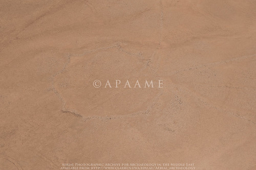
| The faint trace of Hibabiya Kite 18 on an oblique aerial photograph. APAAME_20090917_DLK-0749. |
An important lesson was the fact that often some Kites visible on the satellite imagery were in no way or barely visible on the older HAS imagery, and some were visible on neither but clearly visible on the low oblique imagery of the AAJ project. As much as satellite imagery is an easy and resourceful tool, it definitely can not stand alone. Interestingly - and not something we come across often in Jordan, some of the historical GE satellite imagery showed up Kites easily identifiable on the HAS imagery as crop marks in the now fielded landscape. These would not have been so readily identified without the HAS imagery showing us where to look, but it is an important reminder that remote sensing techniques such as identifying crop marks that are applied in more lush landscapes may also be applied in Jordan at the right time of year, especially in agricultural landscapes like the Southern Hauran.
Labels:
Aerial Archaeology,
Aerial Archaeology in Jordan,
Day of Archaeology,
Google Earth,
Hunting Aerial Survey,
Jordan,
Kites,
Remote Sensing,
Research,
Satellite Imagery,
Southern Hauran Survey
Tuesday, 4 March 2014
Research - KSA 3925-41 - Samhah Kite 35
I have been able to return to some analysis on the many kites in the vicinity of Khaybar in Saudi Arabia today. The good news is that Google Earth has updated imagery in the area, bad news is it looks like some of the kites are a little worse for wear in the face of development. Fortunately we still have the historical imagery to conduct some analysis on the complete site - a bold example of the Kites typical to this region. What is striking in this example is the very straight walls, and numerous hides lined along the pointed extensions of the head. Another feature is the 'barbed' tails of the kite - almost secondary head enclosures connected to the tails close to the head of the kite.
![]() |
| KSA 1:50,000 map square 3925-41 - Samhah Kite 35 on imagery dated 20030106. Click to enlarge. |
![]() |
| KSA 1:50,000 map square 3925-41 - Samhah Kite 35 on imagery dated 20121213. Click to enlarge. |
Labels:
Development,
Google Earth,
Harrat Khaybar,
Historical Imagery,
Kites,
KSA,
Research,
Satellite Imagery,
Stone Structures
Thursday, 12 September 2013
Research: Harrat Khaybar
For quite some time now I have been working on a large group of kites we found in a high resolution window in Google Earth around the ancient oasis and site of Khaybar. The huge concentration of kites fascinated us, so we have been conducting a comprehensive study and gathering data on the kites. This has included taking measurements, mapping, drawing and creating typologies.
While I have been working away I have constantly been struck by the ‘grass is always greener’ mentality, and wondered what lay behind the fuzzy pixels of the lower resolution imagery around my high resolution window in Google Earth. Well, that was answered for me today by Bing maps. My window has been completely blown open, and though for brevity and time’s sake I shall no doubt have to limit my study to the original window in Google Earth, the additional information provided by the larger context is incredibly helpful.
Firstly, I can confirm my suspicions of patterns:– the amazing series of kites that almost appear strung together by their tails that are located to the east of Khaybar have sister strings to the south of the high resolution window.
Secondly, a report with accompanying photography by M. John Roobol and Victor E. Camp in their ‘Explanatory Notes to the Geologic Map of the Cenozoic Lava Fields of Harrats Khaybar, Ithnayn, and Kura, Kingdom of Saudi Arabia’ (1991) that showed what appeared to be a Kite stratified underneath a tongue of Pahoehoe lava of the Habir flow could be identified in the satellite imagery. The area reveals at least one Kite partly overlain by the lava flow – and several other stone structures as well. The Habir flow is ‘historic’ but the exact date is unknown – the eruption date could be anything between the 1st century AD and 1800 (Roobol & Camp: 23).
While I have been working away I have constantly been struck by the ‘grass is always greener’ mentality, and wondered what lay behind the fuzzy pixels of the lower resolution imagery around my high resolution window in Google Earth. Well, that was answered for me today by Bing maps. My window has been completely blown open, and though for brevity and time’s sake I shall no doubt have to limit my study to the original window in Google Earth, the additional information provided by the larger context is incredibly helpful.
Firstly, I can confirm my suspicions of patterns:– the amazing series of kites that almost appear strung together by their tails that are located to the east of Khaybar have sister strings to the south of the high resolution window.
![]() |
| A string of Kites from east of Khaybar (drawn: Rebecca Banks). |
Labels:
Aerial Archaeology,
basalt,
Bing Maps,
Google Earth,
Harrat Khaybar,
Kites,
KSA,
lavafield,
Satellite Imagery,
Saudi Arabia,
Survey
Friday, 8 February 2013
Slide Scanning - Samosata
We are currently digitising the APAAME slide collection of ground photographs, and I had the pleasure of completing the letter 'S' not that long ago.
'S' contained some beautiful sites in SYRIA, SABRATHA on the Mediterranean coast of Libya, and SARDIS in Turkey to name a few.
All of these sites are geoencoded in our database to allow for sites to be searched by location as well as by site name. When I was finding the geographical coordinates for SAMOSATA, I was surprised to come across this in Google Earth (having personally been unfamiliar with the site up until now).
Samosata, ancient city of Commagene, was flooded in 1991 with the construction of the Ataturk Dam, and the modern town of Samsat on the site was moved to the north on higher ground. The remains of the ancient tell, possibly the remains of a palace, can be seen here in the scanned slide, the photograph taken before construction of the dam. It had evidently become a playground for the local children of Samsat. The entire site is now at the bottom of Ataturk Dam.
Very little excavation occurred before the site was flooded. CORONA satellite imagery, freely available through the fantastic University of Arkansas' 'CORONA Atlas of the Middle East' reveals the extent of the ancient site - the walls c. five kilometers long, enclosing an area of roughly
200 hectares (500 acres). This ancient city was the capital of a prosperous Hellenistic kingdom that later flourished under the Roman Empire. This is evident when you provide some perspective: Samosata was roughly three times the size of
Pompeii, and 50 percent larger than Londinium, the capital of Roman
Britain (Kennedy 1998). Should excavations been carried out to a greater extent, finds may have revealed the wealth of the capital of the Commagene kingdom, its later prosperity under the Roman Empire and as home of the Legio XVI Flavia until the 3rd century AD before its gradual demise into obscurity.
Due to the location of Samosata now under some 120m of water, these historical images are all that preserve the knowledge of the site for future generations - who may become keen Underwater Archaeologists to learn more of Samosata.
For more information on the site of Samosata and the flooding of archaeological sites by the construction of the Ataturk Dam: David L. Kennedy (1998) 'Drowned Cities of the Upper Euphrates', Saudi Aramco World 49.5 (Sept/Oct): http://www.saudiaramcoworld.com/issue/199805/drowned.cities.of.the.upper.euphrates.htm
To browse the CORONA imagery, please visit the CORONA Atlas of the Middle East: http://corona.cast.uark.edu/index.html
'S' contained some beautiful sites in SYRIA, SABRATHA on the Mediterranean coast of Libya, and SARDIS in Turkey to name a few.
All of these sites are geoencoded in our database to allow for sites to be searched by location as well as by site name. When I was finding the geographical coordinates for SAMOSATA, I was surprised to come across this in Google Earth (having personally been unfamiliar with the site up until now).
![]() |
| Location of the ruins of Samosata beneath the Ataturk Dam in Turkey (click to enlarge). |
![]() |
| Photograph taken on the tell of Samosata c1970s, the Euphrates River in the background. Photograph: David Kennedy (Click to enlarge). |
![]() |
| Screen shot of Samosata from CORONA Atlas of the Middle East, University of Arkansas http://corona.cast.uark.edu/index.html#bbox=4282983,4509629,4292155,4514526 |
For more information on the site of Samosata and the flooding of archaeological sites by the construction of the Ataturk Dam: David L. Kennedy (1998) 'Drowned Cities of the Upper Euphrates', Saudi Aramco World 49.5 (Sept/Oct): http://www.saudiaramcoworld.com/issue/199805/drowned.cities.of.the.upper.euphrates.htm
To browse the CORONA imagery, please visit the CORONA Atlas of the Middle East: http://corona.cast.uark.edu/index.html
Labels:
Ataturk Dam,
CORONA,
Historical Imagery,
Samosata,
Satellite Imagery,
Turkey,
University of Arkansas
Thursday, 1 November 2012
Publications: Kites–new discoveries and a new type
The discovery of an unusual specimen of kite with a limited distribution between Palmyra and Damascus in Syria led to the formulation of this journal article by David L. Kennedy.

David L. Kennedy (2012) 'Kites–new discoveries and a new type', Arabian Archaeology and Epigraphy 23.2:145-155. You can find it at Wiley Online Library.
The 'sock' kite, fondly at first referred to as a 'Hockey Stick' kite, then (as we were feeling seasonal) a 'Christmas stocking' kite, with its narrow elongated 'shaft' and 'head' off to one side, forms the basis of this article. The discussion encompasses the form, distribution and geography of the new Kite type.
We also cover the extent of our current research on Kites in Arabia, and the article is generously accompanied by useful maps and distribution diagrams of Syria, Jordan and Saudi Arabia, and diagrams of the new Kite type.

David L. Kennedy (2012) 'Kites–new discoveries and a new type', Arabian Archaeology and Epigraphy 23.2:145-155. You can find it at Wiley Online Library.
The 'sock' kite, fondly at first referred to as a 'Hockey Stick' kite, then (as we were feeling seasonal) a 'Christmas stocking' kite, with its narrow elongated 'shaft' and 'head' off to one side, forms the basis of this article. The discussion encompasses the form, distribution and geography of the new Kite type.
We also cover the extent of our current research on Kites in Arabia, and the article is generously accompanied by useful maps and distribution diagrams of Syria, Jordan and Saudi Arabia, and diagrams of the new Kite type.
Labels:
Arabia,
Jordan,
Kites,
Publications,
Remote Sensing,
Satellite Imagery,
Saudi Arabia,
Stone Structures,
Syria
Thursday, 15 December 2011
Syrian Kites
Having been distracted by Jordan and the wondrous Harrat ash-Sham, it is only recently that we returned to monitoring what high-resolution imagery had become available in Syria. A large section of imagery north east of Tadmur (Palmyra) has kept us busy with these stunning kites, as well as a few pendants and bullseye cairns.
![]() |
| Bullseye Cairns along a ridge, Syria. |
![]() |
| A cluster of Kites, Syria. |
![]() |
| Two Pendants along a ridge, Syria. |
Labels:
Bullseye Cairns,
Google Earth,
Kites,
Pendants,
Satellite Imagery,
Syria,
Tadmur
Friday, 7 October 2011
Google: Archaeologist discovers 2,000 sites from thousands of miles away
![]() |
Professor Kennedy projects Google Earth imagery on the high-resolution tiled display in the iVec Supercomputing Lab at UWA. Source: http://www.oneworldmanystories.com/new_sites.html |
See the whole article at Google Earth's 'One World. Many Stories'.
See what else the world is achieving with GE at Search Stories.
Tuesday, 9 August 2011
Bing Maps for Site Identification
After spending about 20 hours in the last week working with Bing Maps (i.e. their aerial/ satellite imagery) I can report that:
It is slow and difficult to work with compared to GE
It is mainly poor resolution of no value archaeologically
Where it is good it is often superb.
For parts of 'Arabia' where Bing is superor to GE I have identified over 100 new Kites (to take just the most obvious cateory)
-DLK
Labels:
Bing Maps,
Google Earth,
Kites,
Satellite Imagery,
Virtual Globes
Subscribe to:
Posts (Atom)