Showing posts with label Survey. Show all posts

Wednesday, 24 February 2016

Publications: Khatt Shebib

Khatt Shebib
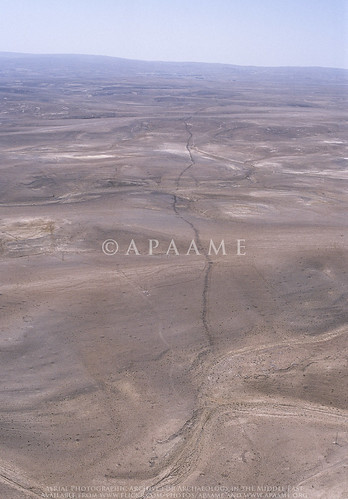
The Khatt Shebib. Photographer: Robert Bewley (APAAME_20051002_RHB-0069).
Recently the academic journal Zeitschrift für Orient-Archäologie published our article on the wall feature in Jordan known as the 'Khatt Shebib'. The content of this article was recently reported on by Owen Jarus in the online science website 'LiveScience' - '93-Mile-Long Ancient Wall in Jordan Puzzles Archaeologists'

The LiveScience feature has led to other media taking up the story. 

The feature was investigated remotely in the course of the active aerial reconnaissance program - the Aerial Archaeology in Jordan project, as well as visited on the ground. The study utilised historical imagery (mainly 1953) and maps, as well as several archaeological survey reports conducted on different sections of the wall, notably those directed by B. MacDonald (Wadi el-Hasa, Tafila to Busayra, and Ayl to Ras an-Naqab Archaeological Surveys), F. Abudanh (in the region of Udruh) and G. Findlater (the Dana Archaeological Survey).

You can find the tagged images of the Khatt Shebib on our Flickr page by following this link.

The synthesis of the information gathered has potentially raised more questions than those that we were able to answer, and we hope this study will soon be followed up by a comprehensive ground investigation of the entire feature and sites directly associated with it which may be dateable.

David Kennedy & Rebecca Banks 2015. 'The Khatt Shebib in Jordan: From the Air and Space', Zeitschrift für Orient-Archäologie 8: 132-154.

Monday, 11 May 2015

Sir Alexander Kennedy (17 March 1847 – 1 November 1928)

Sir Alexander Kennedy
At the time of his first visit to Petra in 1922, Sir Alexander Kennedy was 75 years. The visit certainly made an impression on him as he arranged to return the following year to spend a month there in studying its history and antiquities.   Although he was not an archaeologist by trade (he was senior partner of an engineering firm) – he was one of those early pioneers quick to recognise the importance of aerial photography to archaeologists in attempting to understand the landscape setting, as well as the distribution and range of sites (Bewley & Kennedy 2013: 231). Kennedy lamented the lack of a thorough scientific study of the area around Petra. Of the early visitors who came after Burckhardt in 1812, many of whom were unable to remain for much more than two or three nights, he observed that “…although many published their experiences, practically nothing of scientific value resulted from their visits” (Kennedy 1924: 273).

In a talk he later gave to the Royal Geographical Society, Kennedy gives an insight into what may have driven him to devote his energy to further study of Petra – he considered Musil’s second volume of Arabia Petræa to contain the “first map which possessed any value”, and then Brünnow and Domaszewski’s maps made from their visits in 1897 and 1898 to be the most accurate. He praised their work, however, he observed omissions and guesswork - “the irregularity and roughness of the ground make it extremely difficult to cover every square yard of some 6 or 8 miles; but nothing less would be for any investigation to be entirely exhaustive” (Kennedy 1924: 274).

During his second visit to Petra in 1923, Kennedy, despite his advanced age was busily engaged in mapping and photographing the area in detail. Towards the end of the season Kennedy suffered a stroke, from which he is reported to have recovered rather quickly. Despite the physical strain of the work, he again ventured to continue his study of Petra in 1924, “having at his own expense arranged with the Air Force for a complete aerial photographic survey of the whole area”
Philby (1948: 216) recalls;
“I worked with him on the ground again, and the result was a splendid, profusely illustrated volume called Petra, to which I wrote a foreword, descriptive of the country and its people. It was a remarkable feat for a man, who had never been in the East before, to perform between his seventy-sixth and seventy-eighth years.”

Kennedy’s securing of the services of the RAF squadron at Amman enabled a vertical survey of a wide area around the city centre to be taken - an area covering c.85km2
For an audience familiar with ground views, but unable to visualise the context and landscape, this would have been revelatory. But it was more than a novel view or general photomap; Kennedy evidently examined closely those frames that covered the central area of the city.” (Bewley & Kennedy 2013: 231)
The air-plane view shows also very distinctly the lines of the Roman streets and the outlines of some of some of the principal buildings or places, and many other points quite unrecognizable on the ground. (Kennedy 1924: 278-9). 


Oblique view of Wadi Musa, Petra - Kennedy (1925) Source: Wikimedia Commons.

Bewley, R. & Kennedy, D. (2013). Historical Aerial Imagery in Jordan and the Wider Middle East, in: W. S. Hanson & I. A. Oltean (eds) Archaeology from Historical Aerial and Satellite Archives. London: Springer: 221-242.
Kennedy, A. B. W. (1924). The rocks and monuments of Petra. The Geographical Journal, 63.4: 273-295.
Kennedy, A. B. W. (1925). Petra. Its history and monuments. London: Country Life.
Philby, H. StJ. B. (1948). Arabian Days. An autobiography. London: Robert Hale Limited.

Friday, 13 September 2013

Research: Harrat Khaybar

For quite some time now I have been working on a large group of kites we found in a high resolution window in Google Earth around the ancient oasis and site of Khaybar. The huge concentration of kites fascinated us, so we have been conducting a comprehensive study and gathering data on the kites. This has included taking measurements, mapping, drawing and creating typologies.

While I have been working away I have constantly been struck by the ‘grass is always greener’ mentality, and wondered what lay behind the fuzzy pixels of the lower resolution imagery around my high resolution window in Google Earth. Well, that was answered for me today by Bing maps. My window has been completely blown open, and though for brevity and time’s sake I shall no doubt have to limit my study to the original window in Google Earth, the additional information provided by the larger context is incredibly helpful.

Firstly, I can confirm my suspicions of patterns:– the amazing series of kites that almost appear strung together by their tails that are located to the east of Khaybar have sister strings to the south of the high resolution window.
A string of Kites from east of Khaybar (drawn: Rebecca Banks).
Secondly, a report with accompanying photography by M. John Roobol and Victor E. Camp in their ‘Explanatory Notes to the Geologic Map of the Cenozoic Lava Fields of Harrats Khaybar, Ithnayn, and Kura, Kingdom of Saudi Arabia’ (1991) that showed what appeared to be a Kite stratified underneath a tongue of Pahoehoe lava of the Habir flow could be identified in the satellite imagery. The area reveals at least one Kite partly overlain by the lava flow – and several other stone structures as well. The Habir flow is ‘historic’ but the exact date is unknown – the eruption date could be anything between the 1st century AD and 1800 (Roobol & Camp: 23).

Monday, 5 March 2012

Jarash Hinterland Survey 2010

A short report on the final season of the Jarash Hinterland Survey (2010) co-directed by Fiona Baker and David Kennedy can be found at the great Past Horizons website.

"It is all too easy to get distracted from the survey by kind offers of tea, but as always local knowledge is gained as a result. For instance, to be informed that a tomb containing about twenty sarcophagi on Abu Suwan had been used as a bomb shelter in 1973 and had subsequently been filled in leaving no visible trace represented a great result. The route of a Classical water course in the Wadi Deir – now scattered and bulldozed – was shown to us by a man who played in it as a child. An intense artefact scatter also got us excited, only to be told to our disappointment that it had been deposited by trucks moving earth from elsewhere in the preceding few months."

An overview of the 2010 season appears in ADAJ Vol 55, 2011.

Tuesday, 3 January 2012

Kites in Changing Landscapes

Click image to enlarge. Compiled: Rebecca Banks.
You just have to look at the contrast in visibility between the Hunting Aerial Survey image from the 1950s and a Google Earth image dated 16 June 2004 to see plainly the importance of historic aerial photography for survey purposes. These three kites (numbered 334, 346 and 348) have all but been erased by the agricultural production in this region.