Transliteration of Arabic into English is not a perfect art - many place names will have multiple spellings in circulation making life a little difficult.
We received some clarification from a native Arabic speaker who is also fluent in English regarding 'harrat' - lavafields, over which many of the prehistoric stone built structures such as kites, pendants and wheels are built. The follow advice we hope you will also find informative and useful.
If you are talking about one lavafield it is harra (singular).
Two or more is harrat (plural). (Harrat Khaybar would mean the lavafields (plural) of Khaybar).
Used in conjunction with a specific name it becomes Harret - The great lavafield sprawling across northeast Jordan and into its neighbours is Harret al-Shaam. In Jordan they commonly simply refer to it as Al-Harra.

Monday, 19 December 2011


Thursday, 15 December 2011
Syrian Kites
Having been distracted by Jordan and the wondrous Harrat ash-Sham, it is only recently that we returned to monitoring what high-resolution imagery had become available in Syria. A large section of imagery north east of Tadmur (Palmyra) has kept us busy with these stunning kites, as well as a few pendants and bullseye cairns.
 |
| Bullseye Cairns along a ridge, Syria. |
 |
| A cluster of Kites, Syria. |
 |
| Two Pendants along a ridge, Syria. |
Monday, 5 December 2011
Publications
We have two new publications out recently.
Hibabiya, a site in Jordan that has recently been destroyed, was initially identified as a prehistoric village from aerial photography conducted by the 'Pioneers' in the Transjordan in the 1930s. Reassessment of the aerial imagery and the discovery of crucial dating evidence collected well before its destruction suggests an early Islamic date.
Kennedy, D.L. (2011) 'Recovering the past from above: Hibabiya-an early Islamic village in the Jordanian desert?', Arabian Archaeology and Epigraphy 22: 253-260.
Now out in hardcopy, and not just online:
Kennedy, D.L. (2011) 'The 'Works of the Old Men' in Arabia: remote sensing in interior Arabia', Journal of Archaeological Science 38, 3185-3203.
Full colour images of the whole paper only available in the online version due to printing restrictions in place by the publisher.
Hibabiya, a site in Jordan that has recently been destroyed, was initially identified as a prehistoric village from aerial photography conducted by the 'Pioneers' in the Transjordan in the 1930s. Reassessment of the aerial imagery and the discovery of crucial dating evidence collected well before its destruction suggests an early Islamic date.
Kennedy, D.L. (2011) 'Recovering the past from above: Hibabiya-an early Islamic village in the Jordanian desert?', Arabian Archaeology and Epigraphy 22: 253-260.
Now out in hardcopy, and not just online:
Kennedy, D.L. (2011) 'The 'Works of the Old Men' in Arabia: remote sensing in interior Arabia', Journal of Archaeological Science 38, 3185-3203.
Full colour images of the whole paper only available in the online version due to printing restrictions in place by the publisher.
Wednesday, 16 November 2011
Final flight of the season online!
The last flight of the 2011 season (and one of our largest ever with 3282 photographs) is now online at our Flickr site. This flight took us out into the beautiful desert mesa landscapes beyond Azraq, and then into a previously unvisited area of the basalt country. We revisited some old friends (Maitland's fort and Tell A - impressive sites originally named by RAF pilots on the Cairo-Baghdad airmail route in the 1920s) and photographed hundreds more sites for the first time, including some unexpected kites not visible in Google Earth. Here's a sample:
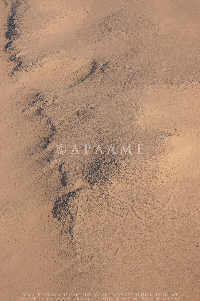
Nukheila Kite 1, Nukheila Kite 2. APAAME_20111027_MND-0447 Photographed by Mat Dalton
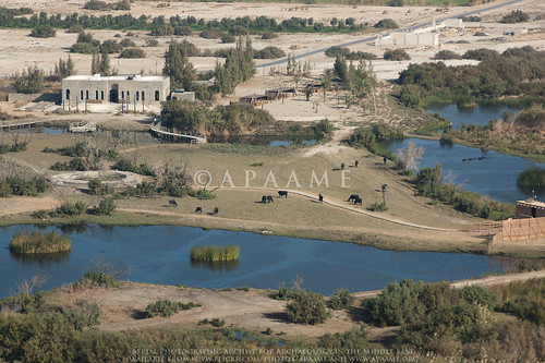
Azraq Shishan Pools. APAAME_20111027_MND-0447 Photographed by Mat Dalton
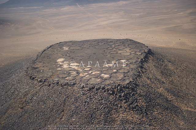
'Maitland's Fort'. APAAME_20111027_DDB-0611 Photographed by Don Boyer
Nukheila Kite 1, Nukheila Kite 2. APAAME_20111027_MND-0447 Photographed by Mat Dalton
Azraq Shishan Pools. APAAME_20111027_MND-0447 Photographed by Mat Dalton
'Maitland's Fort'. APAAME_20111027_DDB-0611 Photographed by Don Boyer
Thursday, 3 November 2011
Homeward bound
Tomorrow will see our last day in Amman for this year's season of flying. It has been a spectacular six weeks with over 30 hours of flying undertaken and over 10 000 photographs taken. We would like to thank the British Institute, Amman (BI) and the Royal Jordanian Air Force (RJAF) for once again accomodating us in Jordan and for their continual enthusiasm for our project. We would also like to thank the many individuals that make this project a success, both on the ground and in the air, and the colleagues who have approached us and taken our flying in new directions.


Wednesday, 2 November 2011
Invisible kites
On our last flight, 20111027, we found something we never knew we had lost, a series of kites across the desert of Jordan that had almost been completely swallowed by the desert sands. These kites were not visible on satellite imagery available through Google Earth and Bing Maps which we use for a preliminary survey of the area before we fly. It was only through low level aerial reconnaisance that we were made aware of their presence. The state of preservation of these kites is so poor that they again disappeared when viewed at low oblique levels and would be completely invisible to anyone driving or walking past.
 |
| APAAME_20111027_REB-0360. |
 |
| APAAME_20111027_REB-0362. |
Monday, 31 October 2011
Mapping and aerial reconnaissance
Aerial imagery and mapping has had a strong relationship in the Middle East since the first ‘Pioneers’ started aerial reconnaissance in the early 20th century. When sourcing maps for this large region for archaeological research, it is often these older maps that can be the most informative. This is partly because urban development at this early period was scant and often it was the ruins of ancient structures, some that have all but since disappeared from view, that provided necessary landmarks.
Often, supplementary publication notes printed on the maps can provide additional useful information. A large amount of aerial reconnaissance and map making was undertaken by British, French, German and Australian armed forces of the areas behind enemy lines with aircraft flying in parallel lines. The details of the squadron and date of the aerial imagery used to compile the map data can be useful for tracking down the original imagery now housed in national archives.
 An observer of the Royal Flying Corps in a Royal Aircraft Factory B.E.2c reconnaissance aircraft demonstrates a C type aerial reconnaissance camera fixed to the side of the fuselage, 1916. Image: IWM Q 33850. Source: Wikimedia Commons.
Often, supplementary publication notes printed on the maps can provide additional useful information. A large amount of aerial reconnaissance and map making was undertaken by British, French, German and Australian armed forces of the areas behind enemy lines with aircraft flying in parallel lines. The details of the squadron and date of the aerial imagery used to compile the map data can be useful for tracking down the original imagery now housed in national archives.
 An observer of the Royal Flying Corps in a Royal Aircraft Factory B.E.2c reconnaissance aircraft demonstrates a C type aerial reconnaissance camera fixed to the side of the fuselage, 1916. Image: IWM Q 33850. Source: Wikimedia Commons.
Subscribe to:
Posts (Atom)