Tuesday, 14 October 2014

Flight 20141013 - Flying South

Qasr Mshatta under cloud - © APAAME_20141013_REB-0028
The second day of the season started with good weather and permission to go south and be allowed access to Qasr Mshatta (an Islamic hunting lodge) now situated on the north edge of the runway at Queen Alia International airport. Unfortunately on arrival the site was cloud-covered but we were welcomed by a wonderful waft of bread being baked in the nearby factory. We moved on south to Machaerus – famous (or infamous) for being the location where John the Baptist lost his head, thanks to Salome’s nefarious activities. It was the subject of a siege by the Romans, trying to recapture it after the Jewish Revolt (AD 66-70), and now undergoing excavations by a Hungarian team.  The siege works are still visible with approximately 10 Roman camps on the surrounding hills.
Machaerus - © APAAME_20141013_RHB-0063
Further south, near the southern edge of the Dead Sea we photographed looting, on a massive scale, of the cemeteries around Fifi, Safi and al-Mazraa (Kh. Qazone).  Our spirits were lifted by some photography of Umm-er Resas (a superb Roman fort and later Islamic town and early seat of learning); then by a return to visit to Qasr Mshatta, this time bathed in sunshine and the smell of bread,  even more appealing as lunch-time approached.
Extensive looting near Safi - the site of Maqbarat Al-Nage'a - © APAAME_20141013_REB-0307
Umm er-Resas - APAAME_20141013_REB-0224
On our third and final trip, and looking for the last site of the day we were having difficultly locating it, not least because of having to keep away from approaching air traffic into Marka (our base) but also because the whole area had been eaten away by massive stone quarries.  We spotted a possible location and as we orbited we realised that we had stumbled across an abandoned Roman (?) quarry with stone columns and sections of unfinished stone,  still visible in the limestone outcrop.  Once again a hugely important site, within a few metres of large destructive modern quarries.  Our pilot (who was having to work on his birthday) took us down to a few feet above the site so we could record it in detail.

Roman (?) Column Quarry east of Marka APAAME_20141013_MND-0768
 - Robert Bewley

Sunday, 12 October 2014

Flight 20141012 - Flying again

October 12th and the first flight of the 2014 season. Bob, Becc and Mat had the usual early start to try to catch the best light, especially as we were hoping for some stunning views of Machaerus, south-west of Amman. However, despite the dawn being very clear and calm there was fog and very poor visibility in that region. The RJAF is brilliant at providing cups to tea and coffee and by 0830 we decided we should change our plans and head north.

Jarash. © APAAME_20141012_RHB-0154.
We photographed some of the more well known sites – Pella in the north, and of course Jerash, both the main city but also looking for some of the smaller features (concerning water management) for Don Boyer (working on his PhD). By chance we also managed to photograph him in the field too.
 
Olive harvest. © APAAME_20141012_MND-0369.
It is also the olive harvest and we saw many sheets (of various colours) underneath olive trees to collect the harvest.

Hayyan al-Mashrif surrounded by quarrying. © APAAME_20141012_RHB-0258.
We photographed over 45 sites, many of which have not been recorded before and may seem to be safe for a few more years. Then as the helicopter orbits a large quarry comes into view and whole hillsides are disappearing for house-building stone. We hope our photographs will be important and useful documents to help understand and preserve many of these archaeological sites in the future.

Friday, 3 October 2014

Publications: Cairn of Hani- Significance, Present Condition and Context

The latest edition (2012) of the Annual of the Department of Antiquities, Jordan has been published with a contribution by David Kennedy with Karen Henderson.

David L. Kennedy (with Karen Henderson) 2012 (2014) 'The Cairn of Hānī: significance, present condition and context', Annual of the Department of Antiquities, Jordan 56: 483-505.

Cairn of Hani. Photographer: Michael Neville. APAAME_20090928_MJN-540.
Abstract: The Ḥarrat ash-Shām, the Basalt Desert of north-eastern Jordan, is strewn with thousands of stone structures; cairns are the most common but few have ever been systematically investigated. The Cairn of Hānī, identified some 60 years ago, is a rare example of a 'Safaitic' cairn with an intact burial which was then systematically excavated and published. Very few other cairns have been excavated since then and the Cairn of Hānī remains by far the most important and informative. Sadly it is now being damaged and may soon be destroyed. The aims of this article are to review the significance of this important cairn, to report on its parlous present condition and to place it in the context of both the handful of other excavated cairns in the region and of the numerous other ancient stone-built structures visible from the air within its immediate orbit.

The article can be accessed on Prof. David Kennedy's academia.edu page: https://www.academia.edu/8735727/The_Cairn_of_Hani_significance_present_condition_and_context

Seminar: Salvaging the Rural Landscape of Roman Arabia

DLK gave a seminar in the Dept of Archaeology at the University of Manchester on 22 September. The seminar was based in large part on the aerial photographs in the APAAME archive which provide marvelous insights into the character of ancient rural sites.

The occasion was an especially enjoyable one as it was almost exactly 43 years since he had enrolled as an undergraduate there and first encountered the superb articles on aerial archaeology in the early volumes of the journal Antiquity.

Monday, 22 September 2014

Photographs: Deir Ain Abata Project

Dr. Konstantinos Dino Politis has made available to APAAME his collection of slides and negatives taken in the course of aerial reconnaissance in Jordan over a period from the early 1990s until the early 2000s. The collection includes informal photography taken from commercial flights flying in and out of Amman as well as professional aerial photography taken by Dr. Politis and his team from a helicopter in the course of their research. A starring feature of this collection is the site of Deir Ain Abata, a site found and excavated by Dr. Politis.
Deir Ain Abata. Photographer: Bill Lyons. APAAME_19990503_BL-0014.
Deir Ain Abata was discovered during an archaeological survey in 1986 near the modern town of Safi in Jordan, located just east of the southern Dead Sea basin. Under threat from erosion from its location on a steep slope and its vicinity to the expanding town of Safi, it was decided the site would be excavated and conserved. The site consists of a large reservoir, a triple apsed basilica church with mosaics, a cave on the north aisle of the basilica, a refectory, and a 'Pilgrim's Hostel' north of the refectory. 1991 excavations exposed the church, the western front of which was at peril of continuing to collapse down the face of the mountain. Conservation work was undertaken in 1994 to stabilise the structure. An inscription revealed that the basilica had been renovated in 691AD - during the Umayyad period. The cave was presumed by the Byzantine Christians to be associated with the Old Testament story of Lot, though why this cave was chosen over the many others in its vicinity is unknown to us. Evidence in the cave showed that it had been in use since the Middle Bronze Age II.
You can read more about the site in Dr. Politis' article The Monastery of Aghios Lot at Deir 'Ain 'Abata in Jordan here: http://www.hsnes.org/pdf/Lot%20monastery%20article.pdf

Other Dead Sea and Jordan Valley sites feature prominently in the collection- such as Bab edh-Drah, Khirbet Qazone, Tall Numeira, Bethany on-Jordan, Wadi Kharrar and Tell es-Sa'idiyeh. The collection compliments that of AAJ's aerial reconnaissance in that it contains photographs from before AAJ began its annual program in 1997, as well as photographing sites unknown to or visited at other times by AAJ.
Khirbet Qazone. Photographer: K. D. Politis. APAAME_19990503_KDP-0139.
The scanning was undertaken on an EPSON Perfection V700 Photo flatbed scanner at 3000 dpi. Due to the age and condition of the slides, results varied - especially in colour output, but unfortunately also in the sharpness of the image. Where possible colour was corrected, and site coordinates and identification, date and photographer identified and placed in the image metadata, but this was not always possible. We have retained any written information from the slides in the image description.

You can find the collection of photographs here: The Konstantinos D Politis Collection
If you have any additional information regarding one of the photographs please do not hesitate to leave a comment on the Flickr photo page. Image requests can be made by contacting Dr. Politis. Copyright is retained by the image photographers.

Friday, 12 September 2014

Research: Qasr Ain el-Beidha

In c. 1981 David Kennedy visited Qasr Ain el-Beidha as part of his investigations into the archaeological traces of the Roman frontier in North-East Jordan. The site shows clearly on the Hunting Aerial Survey imagery of 1953 - a clear perimeter wall c.20m square with a collapsed square tower in the center.
HAS 11.008 overlaid in Google Earth - Qasr Ain el-Beidha is clearly visible on the basalt bottom right. Please click to enlarge image.
Their survey of the site confirmed this:
It consists of a tower, 5.14m square, set within a walled enclosure 21 x 16.18m with, apparently, rounded corners. The tower is built of large blocks of basalt laid in regular courses, 3 of which may be seen and two others inferred. The surviving height of the 3 courses is 1.12m and the wall is 1.2m thick made up of blocks laid as headers and stretchers. Both tower and enclosure wall are much decayed and overlaid with rubble. The latter seems to have been no more than dry-stone built wall and there was only one point, on the S. side, at which evidence of the rough slabs being laid in courses was clear (Kennedy 1982 Archaeological Explorations on the Roman Frontier in North-East Jordan: 186-7).
Qasr Ain el-Beidha general view c. 1981. Image © David Kennedy. Please click to enlarge image.
In addition, Kennedy notes the lines of site from the tower to Qasr Azraq and Qazr Aseikhim, major Roman sites in the area. He concludes that the site likely acted as "an outpost to control access to a water-point" as well as a watch-tower on the route to Qasr Burqu (Kennedy 1982: 187).

Qasr Ain el-Beidha Area
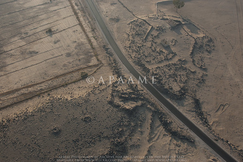
Qasr Ain el Beidha photographed in 2011 - the perimeter wall can just be seen to the left of the road in the picture. APAAME_20111027_MND-0079.  Please click to enlarge image.
Today, the site is lost except for a section of the perimeter wall. We were able to photograph what remains of the site in 2011. A bitumen road has been built since 1978 running east from Azraq straight through the site. Historical satellite imagery in Google Earth implies the road has been in existence since at least 2003. Photographs from the 1978 survey imply that the track had previously gone around the site.
Qasr Ain el Beidha general view c. 1981. The track can be seen running around to the right of the site in the photograph. Image © David Kennedy. Please click to enlarge image.

Monday, 8 September 2014

Video: Aerial photography of Kites

If you want to see Kites from the Jordanian harra like we do - from a helicopter, check out this short YouTube video showcasing some of the Kite footage taken by Matthew Dalton during the Aerial Archaeology in Jordan Project's 2012 season.


Video taken by Matthew Dalton of the Aerial Archaeology in Jordan project, edited by Rebecca Banks. All material is © APAAME.