 |
| The Madaba Martyrs Church, section of Roman Road and the 'Burnt Palace'. Photographer: Robert Bewley. APAAME_20160529_RHB-0017. |

Thursday, 9 June 2016
FL20160529 - Low clouds over the Kerak Plateau
Aiming for a 7 o’clock take off we left CBRL at 0630, Andrea and I, with the sun rising and some clouds in the west. As we crossed the Hejaz railway en route to Marka we were overtaken by the Squadron Commander, who waved and we followed him; I was wondering which gate to the air base he’d use (as there is more than one). Every year we have gone through a ritual at the gate where the guards don’t have a clue who we are, despite assurances the previous day that the guards have been informed. Today we followed him through a gate we knew existed but have never used; this is the gate where we have been supposed to enter - the gate where the guards have been forewarned each day (by the squadron commanders) prior to arrival. As it was our last day of the season we will not know if we will have “cracked” the gate until September, when we hope to return.


Saturday, 28 May 2016
Flight 20160526 - East into the Badia
The second flight of the 2016 season saw Becc and I heading east to the Azraq area, taking in Qasr Aseikhim, a wonderful and significant multi period hilltop site but which is suffering badly from the bulldozer as access roads make it more accessible.
We then headed to assess the impact of the construction of the Azraq by-pass on the stone built structures on the Harrat al-‘Uwaynid. It was truly depressing seeing what had been destroyed without thorough investigations (a presentation at ICHAJ13 by Romel Garib said a survey had been conducted with the help of Prof. Gary Rollefson, but no excavation); truly a missed opportunity as the area is rich in kite-sites, wheels, and pendants (one of which we have been monitoring and has had its tail smashed through – seemingly unnecessarily). These sites are representative of this part of the basalt plateau, and we know so little about them.
 |
| Qasr Aseikhim showing signs of damage from bulldozing. Photographer: Rebecca Banks. APAAME_20160526_REB-0132. |
Friday, 27 May 2016
FL20160523 - Clouds in the North
The Aerial Archaeology in Jordan project has just begun its 20th season (after David’s flight in 1997) and it coincides with ICHAJ13- a conference to celebrate and be informed of recent archaeological work in Jordan. Balancing the commitments of the conference with trying to fly was always going to be tricky but the opportunity to undertake aerial surveys should never be missed, especially in this region.
Jordan never ceases to surprise, and this year has seen the demise of the Air Force’s Huey helicopters, which we had come to love – despite their the noise, and discomfort too, but also great space and views with the door open, and relatively slow speed. So, this first fight (Andrea Zerbini and I) was also experimental in learning the art of aerial photography in a new machine – the Eurocopter (or EC 635).
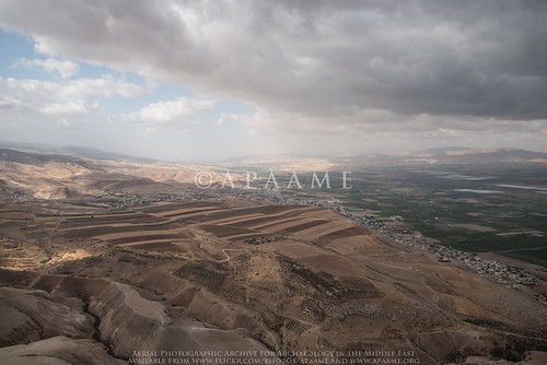 |
| Jordan Valley near Pella. Low cloud made visibility and photography not ideal. Photographer: Robert Bewley. APAAME_20160523_RHB-0219. |
Jordan never ceases to surprise, and this year has seen the demise of the Air Force’s Huey helicopters, which we had come to love – despite their the noise, and discomfort too, but also great space and views with the door open, and relatively slow speed. So, this first fight (Andrea Zerbini and I) was also experimental in learning the art of aerial photography in a new machine – the Eurocopter (or EC 635).
Monday, 23 May 2016
Kh. el-Musheirfeh and MEGA-Jordan
The Jordanian village of Kh. el-Musheirfeh lies about 4 km southwest of the major Nabataean/ Roman/ Early Islamic village/ fort/ town of Umm er-Resas. A further 4 km south is the major archaeological site of Lehun on the rim of the great trough of the Wadi Mujib.
The published literature on the site is limited and the two entries in JADIS and now in MEGA-Jordan are confused, confusing and incomplete.
‘MEGA-J 12338 Musheirifa (sic)’ locates a ‘site’ on the south side of the modern village but that turns out to be only the modern village itself.
‘MEGA-J 12349 Musheirfeh (sic)’ is located 2.5 km to the northeast of the village but in an open area with no traces of any archaeological features.
Surprisingly, therefore, the record reports material of several periods - Nabataean, Roman, Byzantine, Islamic, Modern, and lists eight ‘Site Elements’ including a village, cistern, a bas relief and sherd scatters of the periods noted. The source of the information is given in two published references from the 1930s (Glueck and Savignac, below). A brief glance at these two publications confirms the obvious – there is just one site and it lies under and around the modern village. The second MEGA-J entry (12349) should be deleted and the information there should be transferred to the first entry (12338) under that spelling (as on the 1:50,000 map).
Musheirfeh is in fact an important site as the two published reports show. Glueck was there on 2 June 1933; Savignac in late April 1935. The latter knows of Glueck’s first major report on his survey which included this site but – inexplicably, does not refer to what he had published. i.e. the two reports are effectively independent of one another. Putting the two reports together allows a composite picture which can be considerably enhanced and developed by analysis of the satellite imagery on Google Earth and Bing, by interpretation of the survey aerial photographs of 1953 and the recent low-level aerial photographs taken by the Aerial Archaeology in Jordan project, all of which are in the APAAME archive.
The published literature on the site is limited and the two entries in JADIS and now in MEGA-Jordan are confused, confusing and incomplete.
‘MEGA-J 12338 Musheirifa (sic)’ locates a ‘site’ on the south side of the modern village but that turns out to be only the modern village itself.
‘MEGA-J 12349 Musheirfeh (sic)’ is located 2.5 km to the northeast of the village but in an open area with no traces of any archaeological features.
Surprisingly, therefore, the record reports material of several periods - Nabataean, Roman, Byzantine, Islamic, Modern, and lists eight ‘Site Elements’ including a village, cistern, a bas relief and sherd scatters of the periods noted. The source of the information is given in two published references from the 1930s (Glueck and Savignac, below). A brief glance at these two publications confirms the obvious – there is just one site and it lies under and around the modern village. The second MEGA-J entry (12349) should be deleted and the information there should be transferred to the first entry (12338) under that spelling (as on the 1:50,000 map).
Musheirfeh is in fact an important site as the two published reports show. Glueck was there on 2 June 1933; Savignac in late April 1935. The latter knows of Glueck’s first major report on his survey which included this site but – inexplicably, does not refer to what he had published. i.e. the two reports are effectively independent of one another. Putting the two reports together allows a composite picture which can be considerably enhanced and developed by analysis of the satellite imagery on Google Earth and Bing, by interpretation of the survey aerial photographs of 1953 and the recent low-level aerial photographs taken by the Aerial Archaeology in Jordan project, all of which are in the APAAME archive.
Tuesday, 17 May 2016
Preflight work flow – AAJ May 2016
Our bags are packed, flights booked and we’ll be landing in Amman soon for this our 20th year of flying in Jordan (the first season was way back in 1997)!
This May will see a short series of flights, hopefully three in total – one to the north and along the Jordan Valley, one to the East into the Badia, and one to the south concentrating on the fertile Kerak Plateau.
We will also be attending the International Conference of the History and Archaeology of Jordan and look forward to seeing excellent presentations on the projects and research occurring. You can find the program on the conference website http://ichaj.org/
See you in the air!
This May will see a short series of flights, hopefully three in total – one to the north and along the Jordan Valley, one to the East into the Badia, and one to the south concentrating on the fertile Kerak Plateau.
We will also be attending the International Conference of the History and Archaeology of Jordan and look forward to seeing excellent presentations on the projects and research occurring. You can find the program on the conference website http://ichaj.org/
See you in the air!
Friday, 26 February 2016
Publications (Correction): Pioneers Above Jordan
It has just come to our attention that the article
The image in the text is the following:
The caption should identify the site as 'Ausaji Kite 28'.
The caption in the published text is that for the following image:
The caption from the article reads as follows:
David Kennedy 2012 'Pioneers Above Jordan: revealing a prehistoric landscape', Antiquity 86 (332): 474-491.contains an error for the image and caption of figure 10.
The image in the text is the following:
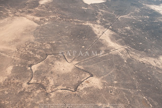 |
| Ausaji Kite 28. Photographer: David Kennedy (APAAME_20091008_DLK-0167). |
The caption in the published text is that for the following image:
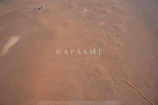 |
| Wisad Kite 14. Photographer: Robert Bewley (APAAME_20091004_RHB-0073). |
Wisad Kite 14 (APAAME 20091004 RHB-0073). A kite surrounded by an immense tangle of walls, few of them visible at ground level. In the top left is the Wisad Police Post on the Airmail Track.
Wednesday, 24 February 2016
Publications: Khatt Shebib
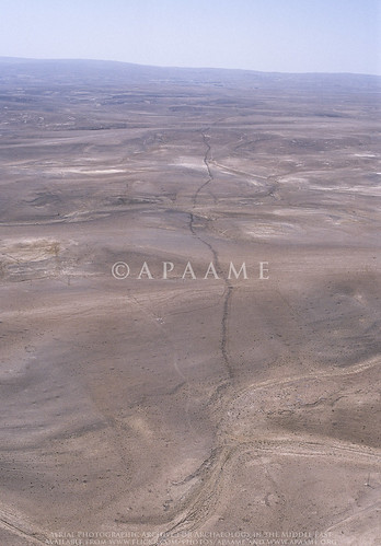 |
| The Khatt Shebib. Photographer: Robert Bewley (APAAME_20051002_RHB-0069). |
The LiveScience feature has led to other media taking up the story.
The feature was investigated remotely in the course of the active aerial reconnaissance program - the Aerial Archaeology in Jordan project, as well as visited on the ground. The study utilised historical imagery (mainly 1953) and maps, as well as several archaeological survey reports conducted on different sections of the wall, notably those directed by B. MacDonald (Wadi el-Hasa, Tafila to Busayra, and Ayl to Ras an-Naqab Archaeological Surveys), F. Abudanh (in the region of Udruh) and G. Findlater (the Dana Archaeological Survey).
You can find the tagged images of the Khatt Shebib on our Flickr page by following this link.
The synthesis of the information gathered has potentially raised more questions than those that we were able to answer, and we hope this study will soon be followed up by a comprehensive ground investigation of the entire feature and sites directly associated with it which may be dateable.
You can find the tagged images of the Khatt Shebib on our Flickr page by following this link.
The synthesis of the information gathered has potentially raised more questions than those that we were able to answer, and we hope this study will soon be followed up by a comprehensive ground investigation of the entire feature and sites directly associated with it which may be dateable.
David Kennedy & Rebecca Banks 2015. 'The Khatt Shebib in Jordan: From the Air and Space', Zeitschrift für Orient-Archäologie 8: 132-154.
Subscribe to:
Posts (Atom)