Thursday, 9 July 2015

Conference: The Palestine Exploration Fund is 150 Years Old

The Palestine Exploration Fund (PEF) was one of those marvellous 19th century initiatives designed to support and promote exploration in a world being shrunk by hugely increased means of travel. Its publications continue still in the form of the Palestine Exploration Quarterly (PEQ) but the spate of publications in the 19th century can all still be read freely and provide marvellous insights into what was being tackled.

Central to PEF research were its expeditions to survey Jerusalem, Western Palestine and later Eastern Palestine. The last of these was undertaken by two men seconded from the Royal Engineers in 1867 (Lt. Warren) and 1881 (Capt. Conder) respectively. Both published extensive reports, including photographs and numerous drawings and a map made by careful triangulation survey. The area surveyed was essentially the hinterland of what was once the Roman city of Philadelphia (modern Amman).

The landscapes seen by the PEF surveyors included hundreds of archaeological sites. Most have been damaged extensively and many totally destroyed. The reason is the steep and rapid rise in population. Like its neighbours, Jordan’s population has grown under the influence of modern medicine lowering infant mortality and extending life expectancy. Like its neighbours it has received waves of refugees but unlike its neighbours, the numbers in Jordan are far higher. The result is an increase of c. 2400% between the 1940s and today. The impact on Jordan’s archaeological heritage has been especially catastrophic in the region in which most of the population lives – the northwest and precisely Amman and its hinterland.

Last Friday (3 July 2015) the PEF organised a one-day conference in conjunction with the British Museum on “Crisis through the Ages” to celebrate its anniversary. About 250 people met in the BM to hear 6 lectures on various periods from early Prehistory to the end of the Ottoman rule in 1918. The entire programme can still be seen on the PEF web site.

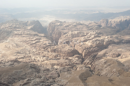
My own contribution - “Losing the Rural Landscape of Roman Philadelphia”, relied extensively on the ways in which a range of sources – published and unpublished, may help define and record what was once there and may yet be salvaged. Especially useful are aerial photographs, the earliest of which for the Philadelphia region are those taken by German, Australian and British pilots in 1918. And now we are flying again in a programme of Aerial Archaeology which began in 1997- the photos from which are part of the c. 90,000 on our APAAME site:https://www.flickr.com/APAAME/collections

Prof. David Kennedy's presentation 'Losing the Rural Landscape of Roman Philadelphia' for the Palestine Exploration Fund 150 Anniversary Conference 'Crisis through the Ages' at the British Museum, 3 July 2015. Photograph: Andrea Zerbini
PEF plans to publish written versions of the lectures from the conference. My contribution is part of wider research for a book in preparation – The Hinterland of Roman Philadelphia.

DLK
Oxford, 9 July 2015

You can follow the Palestine Exploration Fund through their Blog: http://www.pef.org.uk/blog/ or on their Twitter account @PalExFund

Monday, 11 May 2015

Sir Alexander Kennedy (17 March 1847 – 1 November 1928)

Sir Alexander Kennedy
At the time of his first visit to Petra in 1922, Sir Alexander Kennedy was 75 years. The visit certainly made an impression on him as he arranged to return the following year to spend a month there in studying its history and antiquities.   Although he was not an archaeologist by trade (he was senior partner of an engineering firm) – he was one of those early pioneers quick to recognise the importance of aerial photography to archaeologists in attempting to understand the landscape setting, as well as the distribution and range of sites (Bewley & Kennedy 2013: 231). Kennedy lamented the lack of a thorough scientific study of the area around Petra. Of the early visitors who came after Burckhardt in 1812, many of whom were unable to remain for much more than two or three nights, he observed that “…although many published their experiences, practically nothing of scientific value resulted from their visits” (Kennedy 1924: 273).

In a talk he later gave to the Royal Geographical Society, Kennedy gives an insight into what may have driven him to devote his energy to further study of Petra – he considered Musil’s second volume of Arabia Petræa to contain the “first map which possessed any value”, and then Brünnow and Domaszewski’s maps made from their visits in 1897 and 1898 to be the most accurate. He praised their work, however, he observed omissions and guesswork - “the irregularity and roughness of the ground make it extremely difficult to cover every square yard of some 6 or 8 miles; but nothing less would be for any investigation to be entirely exhaustive” (Kennedy 1924: 274).

During his second visit to Petra in 1923, Kennedy, despite his advanced age was busily engaged in mapping and photographing the area in detail. Towards the end of the season Kennedy suffered a stroke, from which he is reported to have recovered rather quickly. Despite the physical strain of the work, he again ventured to continue his study of Petra in 1924, “having at his own expense arranged with the Air Force for a complete aerial photographic survey of the whole area”
Philby (1948: 216) recalls;
“I worked with him on the ground again, and the result was a splendid, profusely illustrated volume called Petra, to which I wrote a foreword, descriptive of the country and its people. It was a remarkable feat for a man, who had never been in the East before, to perform between his seventy-sixth and seventy-eighth years.”

Kennedy’s securing of the services of the RAF squadron at Amman enabled a vertical survey of a wide area around the city centre to be taken - an area covering c.85km2
For an audience familiar with ground views, but unable to visualise the context and landscape, this would have been revelatory. But it was more than a novel view or general photomap; Kennedy evidently examined closely those frames that covered the central area of the city.” (Bewley & Kennedy 2013: 231)
The air-plane view shows also very distinctly the lines of the Roman streets and the outlines of some of some of the principal buildings or places, and many other points quite unrecognizable on the ground. (Kennedy 1924: 278-9). 


Oblique view of Wadi Musa, Petra - Kennedy (1925) Source: Wikimedia Commons.

Bewley, R. & Kennedy, D. (2013). Historical Aerial Imagery in Jordan and the Wider Middle East, in: W. S. Hanson & I. A. Oltean (eds) Archaeology from Historical Aerial and Satellite Archives. London: Springer: 221-242.
Kennedy, A. B. W. (1924). The rocks and monuments of Petra. The Geographical Journal, 63.4: 273-295.
Kennedy, A. B. W. (1925). Petra. Its history and monuments. London: Country Life.
Philby, H. StJ. B. (1948). Arabian Days. An autobiography. London: Robert Hale Limited.

Wednesday, 29 April 2015

Publications: Thapsacus and Zeugma

A recently published book East and West in the World Empire of Alexander: Essays in Honour of Brian Bosworth contains a chapter on Thapsacus and Zeugma contributed by David L. Kennedy.


David L. Kennedy (2015) 'Thapsacus and Zeugma' in P. Wheatley and E. Baynham (eds) East and West in the World Empire of Alexander: Essays in Honour of Brian Bosworth: 277-298
For more details please visit the Oxford University Press page.


From the Oxford University Press website:  
"The essays in this volume - written by twenty international scholars - are dedicated to Professor Brian Bosworth who has, in over forty-five years, produced arguably the most influential corpus of historical and historiographical research by one scholar. Professor Bosworth's name is often synonymous with scholarship on Alexander the Great, but his expertise also spreads far wider, as the scope of these essays demonstrates. The collection's coverage ranges from Egyptian and Homeric parallels, through Roman historiography, to Byzantine coinage.
However, the life of Alexander provides the volume's central theme, and among the topics explored are the conqueror's resonance with mythological figures such as Achilles and Heracles, his divine pretensions and military display, and his motives for arresting his expedition at the River Hyphasis in India. Some of Alexander's political acts are also scrutinized, as are the identities of those supposedly present in the last symposium where, according to some sources, the fatal poison was administered to the king. Part of the collection focuses on Alexander's legacy, with seven essays examining the Successors, especially Craterus, and Ptolemy, and Alexander's ill-fated surviving dynasty, including Olympias, Eurydice, and Philip III Arrhidaeus."

Tuesday, 14 April 2015

New Book on Southern Jordan

Burton MacDonald has had his most recent book just published. It covers southern Jordan where he has conducted successive field surveys over some 40 years and include several APAAME aerial photos.

Chapters survey the successive periods from the Bronze Age to the end of Ottoman rule, each illustrated with useful maps and grounded in his own extensive survey results.

MacDonald, B. (2015) The Southern Jordan Edomite Plateau and the Dead Sea Rift Valley. The Bronze Age to the Islamic Period (3800/3700 BC – AD 1917), Oxford (Oxbow). Ix + 118; 49 colour plates.*

Wednesday, 8 April 2015

New publication on Maitland's Mesa and Wisad Pools, Jordan.

The "land of conjecture:" New late prehistoric discoveries at Maitland's Mesa and Wisad Pools, Jordan. 


A new publication in the Journal of Field Archaeology features APAAME imagery of Maitland's Mesa (Maitland's Fort).

"Qattafi Mesa 4 (Maitland's Fort)"
APAAME_20100601_SES-0095 © Aerial Photographic Archive for Archaeology in the Middle East.

Abstract:
"Major cultural transformations took place in the southern Levant during the late prehistoric periods (ca. late 7th–4th millennia B.C. ). Agropastoralists expanded into areas previously only sparsely occupied and secondary animal products played an increasingly important economic role. In the arable parts of the southern Levant, the olive in particular became increasingly significant and may have played a part in expanded exchange contacts in the region. Technological expertise developed in craft production, and the volume and diversity of status goods increased, particularly in funerary contexts. Mortuary and other ritual practices became increasingly pronounced. General study syntheses, however, rarely include more than a cursory mention of the more arid regions of the southern Levant (i.e., Negev, eastern and southern Jordan, and Syria). Recent investigations indicate that intensive exploitation of the regions may date to these late prehistoric periods, yet this evidence has been difficult to attribute to specific chronological period or cultural affiliations. The Eastern Badia Archaeological Project investigates two regions for a potential florescence of building and occupation during the late prehistoric periods in the eastern desert of Jordan."

The article will be made available through Maney Online:
Rowan, Y.M., Rollefson, G. O., Wasse, A., Abu-Azizeh, W., Hill, A. C. and Kersel, M. M. (2015) "The ‘‘land of conjecture:’’ New late prehistoric discoveries at Maitland’s Mesa and Wisad Pools, Jordan", Journal of Field Archaeology 40: 176-189"

Thursday, 29 January 2015

Flight 20141019 - A new Edomite Stronghold

On Flight 20141019 from Amman to Aqaba six photographs were taken of the dramatic landscape looking west from Qasr Rajif over Wadi Suweid cutting through the sandstone peaks. Unbeknownst to us at the time, the photographs capture the site of an Edomite Fortress.
Wadi Suweid; el-Manktaa (Edomite Fortress)
'el-Manktaa' (Edomite Fortress) - APAAME_20141019_RHB-0287.
Prof. Chaim Ben David alerted us to the existence of the site, known as 'el-Manktaa' to the Bedouins, after he viewed the photographs on our Flickr. His ready knowledge and identification of the site probably due to the fact he had coincidentally visited it just a few months earlier.
The bridge to the site as seen from the wadi valley below. Photograph by Boaz Langford, courtesy of Chaim Ben David.
Following information from fellow hikers Eli Raz and Lior Enmar, who were aware of the phenomenon of Edomite mountain strongholds, in July 2014 Chaim visited two new, apparently as yet undocumented mountain strongholds in the sandstone area below the village of Rajef. The sites are about three kilometers south of Qseir, the southernmost known stronghold until this latest discovery.
Crossing the bridge to the site. Photograph by Boaz Langford, courtesy of Chaim Ben David.
The isolation of the site in the landscape is easily discernible on Google Maps (click here to go to the location). The small Bedouin constructed bridge used by Chaim and his companions to cross into the site can just be seen on the satellite imagery across the fissure that marks the western boundary of the stronghold. Structures are not readily visible on the satellite imagery, or on the low level obliques taken by AAJ, but photographs taken by Boaz Langford from the visit with Chaim show collapsed stone built structures.

Evidence of stone structures at the site. Photograph by Boaz Langford, courtesy of Chaim Ben David.
Chaim’s information means that we can add the coordinates of these sites to future AAJ flight routes, so that the site may be captured in full instead of in a lucky low level oblique landscape shot. Moreover, our better understanding of this type of site means in future we will be better able to discern these sites from the air. Chaim has offered his knowledge to the identification of many sites taken during the Aerial Archaeology in Jordan project's seasons of flying, and taken us on a couple of his amazing hikes across the landscape to investigate features further. Many thanks!

Following is an excerpt from Chaim Ben-David’s forthcoming publication in ARAM Periodical:
“You who live in the clefts of the rocks” (Jer.49:16): 
Edomite Mountain Strongholds in Southern Jordan

Tuesday, 13 January 2015

Goodbye 2014

What a year it has been!

6 flights of aerial reconnaissance as part of the Aerial Archaeology in Jordan Project 2014
9,522 aerial photographs taken as part of the Aerial Archaeology in Jordan Project 2014
3,216 slides/film digitised
17,344 images cataloged and uploaded to our Flickr archive

Conferences attended:
Presentations:
Publications:
Submissions:
  • David Kennedy and Rebecca Banks, 'The Khatt Shebib in Jordan: from air and space', Zeitschrift für Orient-Archäologie
  • David L. Kennedy and Brett D. Hirsch, 'Prime Suspect: William Cowper Prime in the Holy Land and the identity of 'An American' in Harper's New Monthly Magazine, 1858', Palestine Exploration Quarterly
  • David Kennedy, Rebecca Banks and Matthew Dalton, 'Kites in Saudi Arabia'