Showing posts with label Roman Road. Show all posts

Thursday, 7 January 2016

Jordan Times article reports damage to the Via Nova Traiana

Ammar Khammash recently wrote an opinion piece in The Jordan Times regarding damage to a major monument in Jordan from the Roman period - The Via Nova Traiana ('Ancient Rome Reawakened', The Jordan Times, 27 December 2015: http://www.jordantimes.com/opinion/ammar-khammash/ancient-rome-reawakened).

This great Roman highway was constructed soon after the annexation of the Nabataean kingdom in AD 106 and – as some of its milestones declare, Rome – under the Emperor Trajan, had ‘redacta in formam provinciae Arabia viam novam a finibus Syriae usque ad Mare Rubrum” (“turned Arabia into provincial form and built a new road from the boundaries of Syria as far as the Red Sea”). Hence the modern description of it as the Via Nova Traiana.
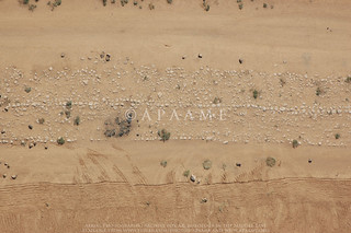
Jimal VNT
A stretch of the Via Nova Traiana near Umm el-Jimal. APAAME_20060911_DLK-0290. Photographer: David Kennedy.
The road begins at Bostra in southern Syria then traverses Jordan from west of Umm el-Jimal in the north to Aqaba in the south. Though it bears the name of the Emperor Trajan, it is generally thought the road made use of earlier thoroughfares through the landscape, and its milestones are testament that it continued to be used well after, to the extent that sections of it are beside or underneath modern stretches of road. Well-preserved sections of the ancient road are increasingly difficult to find as development in Jordan continues at speed with the many pressures of increased demographics and modern infrastructure. In some places the road can be found complete with its paved substructure, in others only a side kerb of stones survives and paving may have never been laid; many sections are completely lost.

Due to his previous research regarding the course of the road through the landscape, Khammash reports that he met the news of the new wind farm in the Tafila Governorate with trepidation, and his visitation to the area confirmed his fears. He found that the road was cut in several places by the earthworks, platforms and access roads for the network of towers.

Khammash specifically reports that the Via Nova Traiana is directly intersected by the construction of turbine WTG 32. The Final Report for the proposed wind farm states that 'No Archaeological Remains' were found at this location (Table 13-2). Khammash also reports intersections or cuts in the vicinity of turbines WTG 26, 29 and 38. The first of these is also reported as having 'No Archaeological Remains' while the other two locations are from relocations to avoid other archaeological sites.

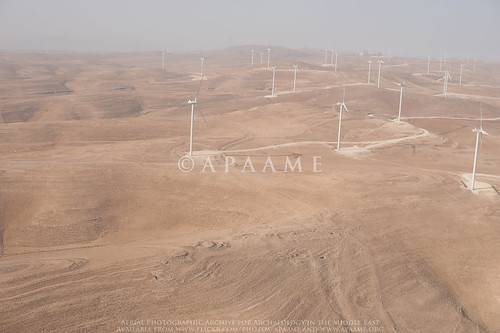
By chance, the Aerial Archaeology in Jordan Project flew in the vicinity of the wind farm in transit to and from sites planned for the 5th flight of its 2015 season. Dr Robert Bewley captured the site of Kh. ad-Dabbah (JADIS:2101035; MEGA-J:4804) in passing. What you can just see in the image is the traces of the Via Nova Traiana extending from the right of the site of Kh. ad-Dabbah in the foreground to the platform of the wind farm in the middle distance.

The Final Report documents that of the proposed 38 locations for wind turbines, 16 were changed due to concern for archaeological material (Table 13-2). Consultations and site visits through April until September of 2012 are listed in the documentation (Tafila Wind Farm Environmental and Social Impact Assessment, Stakeholder Engagement Plan, Table 3-1). Nowhere in the documentation is knowledge of a Roman road mentioned.
The Executive Summary for the then proposed wind farm states:
"...Where historical monuments were found, the locations of the turbines and the roads were revised. 
Even though the wind farm is planned in such a way that no historical artifacts are impacted, excavation works during the project construction might reveal further archaeological remains. Thus every effort must be made during construction to prevent damages on any findings."
Tafila Energy Project, Tafila Goverorate (Hashemite Kingdom of Jordan) Executive Summary, Report No. 11-1-3058f, CUBE Engineering GmbH, Al-Rawabi Environment & Energy Consultancies, 20th December 2012: 9.
The literature survey may perhaps be indicative of how the knowledge of the major Roman Road did not come to mind of the surveyors: two of the major archaeological surveys conducted in the area are not mentioned in the documentation - The Tafila-Busayra Archaeological Survey and the Dana Archaeological Survey as well as a survey conducted by Prof. Zbigniew Fiema which exists as a report in the Department of Antiquities. Also of note is that nowhere could I find in the assessment documentation reference to the current SMR for Jordan - MEGA-J, only its outdated predecessor, JADIS.

No comprehensive map of the distribution of these sites over the extent of the proposed wind farm is provided despite mention in passing in the Environmental and Social Mitigation Plan of numerous archaeological sites over the proposed area, a conducted survey, and consultation of aerial map surveys and experts in the field (Section 11.1). This is despite profuse inclusion of other GIS analyses in the project assessment, including a distribution of the 'best known' archaeological sites in the region which were assessed for indirect impacts.

It is clear that this international funded project for renewable energy in Jordan has done an assessment of the direct and indirect impacts of the project on the archaeological landscape and made alterations to their plans to best accommodate what they knew of the archaeological and heritage environment. So how did the major thoroughfare of this part of the Roman Empire escape inclusion in their assessments?

Is it simply a case that something as slight as a row of kerb stones was overlooked, or not considered substantive enough to warrant remark? An act of unconscious archaeological snobbery where a built structure is considered but a surface feature is dismissed? The reports do not tell us if the road was successfully investigated if it was discovered over the course of the construction of the wind farm. The Environmental and Social Mitigation Plan implies that his would be the case, and we for one hope there is an archaeological report on the excavation of a section of the Via Nova Traiana forthcoming. If not, we join Ammar Khammash in hoping that this destruction may highlight the importance of documenting and preserving where possible what is left of this ancient monument.

All assessment documents for the Tafila Wind Project were accessed through the International Finance Corporation website:
Tafila Wind Environmental and Social Review Summary, http://ifcext.ifc.org/ifcext/spiwebsite1.nsf/vwAllDocumentsByUNID_NL/1E151BC4ED5004B885257AF7006F1151?opendocument, accessed 5 January 2016. Hyperlinks have been provided throughout the text.

Aerial Archaeology in Jordan Project's images of the wind farm taken in 2015 can be found on the APAAME Flickr page. Other numerous aerial (and a number of ground) photographs of other stretches of the Via Nova and sites along its length can be found on the Flickr web site for APAAME by searching for “Via Nova Traiana” or “VNT”.

Published surveys mentioned in this text:
Findlater, George Macrae. 2003. Imperial control in Roman and Byzantine Arabia: a landscape interpretation of archaeological evidence in southern Jordan, PhD Thesis The University of Edinburgh: Appendix 1 Gazetteer of Archaeological Sites of the Dana Archaeological Survey.
MacDonald, B., Herr, L.G., Neeley, M.P., Gagos, T., Moumani, K., and Rockman M. 2004. The Tafila-Busayra Archaeological Survey 1999-2001, West-Central Jordan, American Schools of Oriental Research, Boston, MA.

Monday, 20 October 2014

Flight 20141019 - The Via Nova Traiana in Central Jordan

The great Roman highway ran from Syria down the length of the Emperor Trajan’s new province of Arabia to Aila (Aqaba) on the Red Sea. Nineteenth century western travellers and explorers ‘east of Jordan’ regularly reported following it for mile after mile and noting many of the hundreds of milestones still to be seen. In the twentieth century it suffered badly with great stretches disappearing beneath modern roads or ploughed away by farmers and developers; milestones have been smashed or bulldozed aside. Happily there are still places one can see stretches surviving, usually in the more remote parts of modern Jordan.
Bulldozing damage to Rujm el-Faridiyyeh. © APAAME_20141019_DLK-0180
Our flight yesterday (Sunday) included Rujm el-Faridiyyeh, a Roman road-station on the Via Nova just south of the Wadi el-Hasa. It was the subject of a striking RAF aerial photograph of 1937 and was drawn in the course of Burton MacDonald’s Wadi el-Hasa Survey (1988) 30 years ago (Kennedy and Riley, Rome’s Desert Frontier, 1990: 86-9). Sadly we found that even on this fairly isolated stretch of the plateau, a bulldozer has (again) been at work – for no apparent reason as there is no development at that point.
Milestation along the VNT. © APAAME_20141019_DLK-0203.
On the other hand, the road appears today almost intact and showing far more strikingly as a classic Roman road than even the old RAF photo had suggested. Our experience in Jordan over the course of several attempts since we began in 1997, is that Roman roads are often quite difficult to re-discover from the air unless well-preserved. Not so this time. From the air we could clearly trace the road running for at least 5 kilometres (about 3 Roman miles) and with intermittent stretches thereafter. As MacDonald could describe from his ground visit in the 1980s, you can still see the side kerbs and the central spine of the substructure (which is what survives). Particularly interesting was the cluster of milestones at one Milestation, some still standing after some 1800 years.
VNT and Tower. © APAAME_20141019_DLK-0189.
There is a need to re-visit on the ground this superb stretch of road which is coming under increased threat from agriculture and some building nearby. Even more important is to trace it beyond the remains of the bridge across the stream of the Wadi el-Hasa and up the steep slope to the northern plateau. Hints of the line reported over a century ago are still visible from the air. More striking are the collapsed towers in its vicinity and – best of all, an apparently newly discovered fort. As it lies on a promontory overlong the Roman road it may be Nabataean and/ or Roman.

Aina Fort 1. © APAAME_20141019_DDB-0137.
- David Kennedy

Edit November 26, 2014: Aina Fort 1 is Kh. al-Medeineh (on the Wadi al-Hasa) - Glueck's site 222 in Explorations of Eastern Palestine II (1935): 104-5. Thank you to Dr. Haim Ben David for the info.

Friday, 19 April 2013

Field Trip 19 April 2013 - Flying follow up

Salvaged columns on display at Umm el-Qundun.
Friday again and after our two flights this week it was time for some terrestrial visits. The main purpose was to follow up on two sites recorded from the air last Sunday and to check on another which we have been monitoring (and will report on in the next Blog).

Umm el-Qundun lies on a hilltop 13 km SSE of the centre of Roman Philadelphia (Amman). The region all around is fertile red soils and intensely farmed today – all along the roadsides farmers have set up boxes of their freshly harvested tomatoes, beans, melons etc. When we flew over the site on Sunday Mat photographed a large house on the hilltop in which he had spotted what looked like parts of columns lined up along a verandah. Zooming in on the photos in the Institute later that day confirmed they seemed to be parts of ancient columns.

Qundum was our first port of call this morning and easily found. It is a delightful house, seemingly unattended except by some loud (and, happily) enclosed dogs in the courtyard. The walls are largely constructed from what look like re-used squared blocks of ancient stonework – presumably recycled from some nearby ancient site. What caught our attention, however, was first the row of broken columns we had come to see (columns rather than milestone drums as I had hoped might be the case) then all the other pieces of architectural decoration: a few column capitals, piece of architrave, some finely carved pieces. Round the corner was the covered mouth of an ancient cistern and a rebuilt second cistern with a plaque recording it had been done by ‘The Messengers of Peace NGO’ and financed by ‘OME World Organization for Education’ of Geneva.

Of course the place is ‘known’ – a German survey had recorded material there as had a later team of the Madaba Plains Project. They noted the architectural pieces (without illustrating any) but supplied the detail that the farm belonged to Mamdou Bisharat and the pieces had been collected from the vicinity. As it happens I had met Mamdou – a very courtly gentleman, some years ago at drinks in his Amman home then subsequently swum in his delightful natural hot springs farm beside the R. Yarmuk just north of Umm Qeis (Gadara) and near where the Roman thermal spring site lay (now in Israel across the river). Both his town and Umm Qeis houses are festooned with pieces of ancient architecture and sculpture (whose provenance he has reported to the DoA).
Roman road on the outskirts of Hanafish. © APAAME_20130414_DLK-0075.
While searching for a possible stretch of Roman road a few kilometres southwest on the southern outskirts of Hanafish we visited the remains of a (Roman?) farm on the hilltop south of the modern town and the extensive traces of monumental tombs, rock-cut graves and cisterns. The ‘road’ turned out to be a phantom, but on our flight the keen eye of Bob Bewley spotted a genuine Roman road cutting the phantom at right angles. It showed from the air as a stretch of apparent kerbing. On the ground it was even more convincing. If the alignment is extended it picks up stretches of modern road and track to the south-southwest which point very closely to the small Roman town of Ziza (modern Jiza), famous for its huge ancient reservoir and, now following excavation, a church. It also figures in the Roman document called the Notitia Dignitatum – a battle order for the entire army, empire-wide, c. AD 400, which records: Equites Dalmat[ae] Illyriciani, Ziza (The Dalmatian Illyrian Cavalry, at Ziza). Such a road is not unlikely but this seems to be the first hard evidence for it.

-DLK
Roman road near Hanafish at ground level.
All photographs taken by the Aerial Archaeology in Jordan Project are uploaded to the APAAME Flickr site after cataloging. Follow us on Twitter at @APAAME for updates.


Friday, 25 May 2012

Descending the Zoar Ascent

Haim Ben-David at the start of the hike.
Photographer: David Kennedy. Click to enlarge.

Thursday at 4 am we left Amman on a 2.5 hour drive to the point on the northern rim of the Wadi el-Hasa. Our party of five was led by Prof. Haim Ben–David who has hiked up and down some of the more rugged parts of the escarpment overlooking the Dead Sea and Wadi Araba. Several of these tracks follow or intersect some of the more spectacular Roman roads in the Near East. The track that starts just west of Mazar is a mixture of bull-dozed track, Roman road and footpath. In places there are traces of efforts to plough up a few of the flatter bits of ground. Most of the route is steep and rugged.

The direct distance is 8 km; the actual distance zig-zagging is probably twice that. Equally important is that the hike is largely over boulder-strewn ground in which it is usually impossible to stride out – instead the hiker has to be eyes-down and carefully picking footfalls. And it is steep – a vertical drop between start and the town of Safi is about 1.3 km.
A stretch of road with parallel steps.
Photographer: David Kennedy.
Click to enlarge.

Setting off at 06.30 the start was easy and cool; by 08.15 when we stopped to breakfast in a shady place it was hot. An hour more and it was VERY hot and rising. A lot of water was drunk and I needed three coats of factor 30+ sunscreen.

Haim is a skilled guide on the track and with impressive – almost incredible energy. I was impressed to hear he had once walked UP the Ascent – then down the adjacent wadi the next day. By the time we were half way down and at 200 m asl I was incredulous at the thought of walking up this route. Walking down was demanding on the calves; walking up would be a challenge to the lungs.


The Roman road is quite clear in places. The edges are usually a double thickness of roughly square boulders about 3 m apart. In places the path between is divided up by widely-spaced steps. On sharp bends there are supporting walls. We managed to walk along quite lengthy parts of the Roman road but probably the best section is near the end where the current track is some distance away. Instead we had to view the road zig-zagging up a distant slope.
The unreachable but tempting zig-zag of the Roman road near Safi.
Photographer: David Kennedy. Click to enlarge.

We finally reached Safi (-300 m bsl) at 15.30. Not without tears and pain – the undersigned became jelly-legged soon after midday and found walking, much less picking a path between, on and down boulders without losing balance, ‘challenging’. Shade was almost non-existent but the temptation to sit down had to be resisted. Fortunately Haim, Yeshu and Ezer were fitter and kept me going to where the guide had driven round and was ready to meet us. A day to remember. I cannot imagine I would ever do that walk again but I would certainly like to tackle it from the bottom to walk the bit of Roman road we saw but could not reach.
Our track ahead and soon to pass a fortlet on a plateau.
Photographer: David Kennedy. Click to enlarge.

As Haim points out, the engineering of the road implies a government agency rather than any local authority. Yet there are no milestones on the road, no graffiti by exhausted traveller; there is an apparent fortlet and there are at least three open-air mosques. Pottery sherds crop up regularly along the road and they are abundant at a few places.

We had already photographed the fortlet from the air thanks to co-ordinates from Haim. Now we can trace the route more accurately from our GPS track and compare the landscape on the 1953 vertical aerial photos. We can return and photograph it on a future flight. More important, there is scope and a great need for some energetic archaeologist to study the road in detail – especially as parts are being destroyed.

DLK

Sunday, 9 October 2011

Limes Academicus and Jordan never ceases to surprise

Recent arrivals for this season include myself from the UK, Karen Henderson and Don Boyer from Australia. Don’s arrival was the most impressive; he hardly had time to drop his bag inside the door of the Institute and he was being whisked off, with the rest of us, to Qasr Hallabat (see Ancient Jordan from the Air pages 177-178, and looking very different from today).

However that’s getting ahead of ourselves: yesterday David, Mat and I went to look for a Roman road, spotted at the end of last season in the western suburbs of Amman. We have spent many hours, on previous excursions, both driving around and flying around possible Roman roads, but this time we found it first time; excellently well preserved in one small section but completely trashed in others – either built over, scraped away or piled up with stones and rubbish.

Having had success here we had a plan to go to the Wadi Seer for Mat to see Qasr al Abd (also known as or Iraq al Amir, which is the name of the nearest town); one of the most wonderful places in the region, and after a slight detour the plan worked. The building is such an amazing architectural statement – built by Hyrcanus, one of the Tobiad (a Hellenistic family) - clearly a demonstration of their wealth and status. The size of the limestone blocks is incredible (and clearly from the Greek tradition going back to the buildings at Mycenae – though this is much later). Unfortunately the size of the stone construction was also its downfall, as the next earthquake (in 365 AD) brought the stone blocks crashing down, not to be restored until the 20th century.

Qasr al Abd (near Iraq al Amir). Photographed by Bob Bewley

On Saturday David had been invited by the excavator and restorer of Qasr Hallabat (Dr Ignacio Arce) to accompany him and a few Italian visitors to visit the site. We tagged along, as did a few more Italian friends, so we were a party of almost 15. The site started life as a Roman fort (and possibly an earlier, Nabatean site too) and then developed – as the balance of power shifted - into a Christian church and then an Islamic centre of power and religion.

Ignacio then treated us to a rare and stimulating open-air lecture, on his version of the history of the region from the early Roman period, through the Ummayyad expansion and up to the Abassids (10th century AD. This tour de force introduced not only a wonderful overview of the reasons for the collapse of the Roman, Persian, Ottoman and British empires (it was the nomads…) but also new concepts to the barriers for a modern appreciation of new insights; hence the title of this page, the Limes Academicus. The barriers (Limes) being in the minds of scholars not seeing the importance, throughout both prehistory and the historical periods, of the social relations between the conquerors and conquered, between (especially in this region) nomadic tribes and the farmers in settled villages and towns. It wasn’t all about power and the economy but the long-term impact on the local, indigenous population too.

The other part of the title is not only because of the amazing work the Spanish and Jordanian teams have done on the reconstruction at Hallabat, but also at the nearby bath house, with the very appropriate name - the "Baths of the Desert" or Hamman as-Srah; where the dome has been reconstructed (on the inside) using a wonderful fluted design of wood. So unexpected and such quality but the sting in the tail is that project is in dire needs of extra funds to complete its work. If only there was a Heritage Lottery Fund in Jordan….

The restored fluted wooden dome of Hammam as-Srah. Photographed by Bob Bewley

-Bob