Showing posts with label Historical Imagery. Show all posts

Thursday, 21 September 2017

The UCL Institute of Archaeology Air Survey Photographs: an archaeological reference collection of Royal Air Force aerial imagery from 1918–1939

This blog was first featured on the EAMENA blog on September 4, 2017. It is replicated here by the author. The digitised collection is available for browsing through an Album on our Flickr. The collection material is accessible through contact with the UCL Institution of Archaeology Collections Manager Ian Carroll: i.carroll@ucl.ac.uk.

The UCL Institute of Archaeology Collections Air Survey photographs comprise a series of glass plate negatives, cellulose negatives, safety negatives, and prints of Royal Air Force (RAF) aerial photographs taken between 1918 and 1939. The photographs are predominantly of Iraq, the former Transjordan, Egypt, and Sudan (see distribution map). Recently, EAMENA put out a call for information regarding collections of aerial photography. One of the reasons for this is that the aerial photography conducted by the Royal Air Force in the Mandate territories was not comprehensively archived, and some of it was destroyed once it had served its immediate use. What has survived is fragmented, so we are trying to find and piece together those fragments because these images are an amazing resource for discovery, monitoring and analysis of archaeological sites. The UCL collection is one of the larger collections of RAF imagery from the Middle East, and its survival for use in archaeological research was no accident.
One of the glass plate negative boxes, and glass plates encased in RAF envelopes at the UCL Institute of Archaeology Special Collections. Photograph: Rebecca Repper.

This collection originated from a deposit made by O.G.S. Crawford to The British Museum of "obsolete" photographs collected from the RAF during a tour of Iraq, Transjordan, and Egypt in 1928, made at his own expense. In a presentation to the Royal Geographic Society (RGS) and published in The Geographical Journal in 1929, Crawford describes how he enlisted the help of the Air Ministry to photograph sites of archaeological interest, and stated that "these, and also many existing but obsolete negatives abroad, should be handed over to the Director of the British Museum, to form the nucleus of a national collection." The exact contents of this original deposit, however, are not entirely clear from the written record. Crawford stated to the RGS a number of 1,700 negatives; the British Museum Trustee Minutes of 8th June 1929 state 1,150 glass plate negatives and nine rolls of film. This original deposit is likely to be those items now in the UCL Collection, numbered AP1–1356, or possibly all the way to AP1405 (note that there are no items between AP1101–1202 due to misnumbering). As stated, these are predominantly glass plate negatives (most likely gelatin dry plate). It is important to note that many of these are re-photographs of prints or mosaics, which was possibly a mechanism used by the RAF for copying developed material. The original rolls of film have been copied to safety negative film.

Crawford arranged with the Air Ministry for further photography of archaeological sites to be contributed, and the collection continued to grow from these subsequent deposits. The British Museum Trustee Minutes note at least two deposits of this nature: one in 1931 (Trustee Minutes 12th December 1931) and another in 1938 (Trustee Minutes 14th May 1938). These are predominantly 5 x 5 inch cellulose negatives, and some rolls of film (that have been copied to safety negatives). The UCL collection also includes photographs taken as part of Sir Aurel Stein's aerial survey of Iraq with the help of the RAF in 1938 and 1939, so at least one further deposit must have been made, but whether this came from the Air Ministry or from Stein himself has not yet been confirmed. Prints of the majority of this Stein survey material are at The British Academy Archive, though there is some variation in annotation (ASA/3 - see our previous blog, and the Flickr photoset by APAAME). This collection of aerial photographs was originally going to be transferred from the Department of Western Asiatic Antiquities at the British Museum to the Ordnance Survey, where a plan for an aerial photographic library was underway (Trustee's Minutes 12th October 1940, 11th October 1941), but this never came to pass. Instead it was agreed that the collection should be transferred to the Library of the Institute of Archaeology (The National Archives, OS1/384, letter marked '58A', dated 31 May 1949) at Crawford's suggestion (Trustee's Minutes 9 July 1949) to continue as a collection for archaeological reference and something that would be of interest to students. It is now part of the UCL Institute of Archaeology Collections.
Aerial photographs AP816-920, 922-950 of the site of Ur. Background imagery: Google Earth.
The photographs are vertical, oblique, and photo-mosaics. Many of the vertical images comprise series of overlapping photographs. These include such major sites as Ur (AP702–726, 742–886, 888–896, 908–915, 951, 953–955), Mosul (AP451–477), Sulaymaniya (AP678–699), Tell Afar (AP13–27), Erbil (AP319–356), Ctesiphon/Seleukia (AP108–173), Azraq (AP972–1021), Abydos (AP1241–1283), and Giza (AP1615–1622, 1623a).

Photo-mosaics produced from the aerial photography taken by 14 Squadron are particularly common for former Transjordan, including a continuous photo mosaic over four frames of the River Jordan (AP1086–1089), and for the area of Petra and Beidha (AP1286–1289). In only a few instances are the individual frames and the photo mosaic both included in the collection, for example, for Qasr Uweinid (AP1036–1038 and AP1040). This is useful because the creation of a photo-mosaic introduced further distortions into the imagery.

Qasr Uweinid individual frames AP1036-1038 (above), and their mosaic AP1040 (below). Background imagery: Google Earth.

The collection captures some sites in the process of excavation, such as Ur and Khorsobad, and also includes a small number of ground photographs of these two sites (AP645–665 and AP1806–1812, respectively), as well as a single ground shot of Nineveh (AP1805).

The majority of sites captured in Egypt and Sudan follow the Nile, including an extensive collection of photographs of the well-known site of Giza, as well as other pyramids further south. An exception is a small series capturing archaeological sites in the vicinity of the northern section of the Suez Canal and the Sinai Peninsula (AP1591–1614).
The distribution of sites featured in the UCL Institute of Archaeology Air Survey photograph collection negatives. Background imagery: Google Earth.
This collection was digitised by the APAAME project in 2016 in agreement with the UCL Institute of Archaeology, and in co-operation with the EAMENA project. Where known, images have been geo-located, and this process is on-going. Interestingly, one image, AP357, seems, due to the architectural style visible in the photo, to not be of a site located in the Middle East or North Africa region at all and remains a mystery. Geo-location is assisted by the annotations on the (deteriorating) photograph envelopes; where this type of information was available, this has been included in the image caption on the APAAME Flickr page. These annotations are particularly rich for the original deposit by Crawford, where the majority of glass plates are enclosed in RAF aerial photograph annotated envelopes (or replacement 'Antiquity' or 'Ordnance Survey' stationery), and are secured in wooden glass plate cases.

Only the negatives were digitized. Some interruptions in the sequence of photographs suggest some items are missing, while others have been broken (where possible the latter have been included in the scanning process). There are also prints in the collection, but these have not yet been fully investigated. All enquiries regarding access to the collection and reproduction of the images must be directed to the Collections Manager, Ian Carroll: i.carroll@ucl.ac.uk. We thank Ian Carroll and UCL Institute of Archaeology for their co-operation and assistance during the lengthy digitisation process. Thanks also go to Francesca Hillier (The British Museum Archive), Patricia Usick (The British Museum Egyptian Department), and Angela Grimshaw (The British Museum Middle East Department), who have assisted in our enquiries regarding the provenance of this collection.

The digitised collection can be browsed on the APAAME Flickr page.

Information regarding the UCL Institute of Archaeology and their Collections and Archive can be found at the following links: http://www.ucl.ac.uk/archaeologyhttp://www.ucl.ac.uk/archaeology/about/facilities/collections

Wednesday, 2 November 2016

‘View Counts’ on APAAME’s Flickr Site

Since its establishment in 2009, what Flickr calls ‘View Counts’ have reached 7.153 million. After a slow start the number now rises by about a million every few months and the site has 452 ‘Followers’.

A sign of the times is that the all-time most viewed photograph is one of Aleppo, seen 3850 times. Not one taken by our team but the work of No 1 Squadron of the Australian Flying Corps on 23 October 1918 from 7000 feet. It is labelled ‘Aleppo from SW’. The original print is held in The National Archives at Kew in the UK.

The flight – just two and half weeks before the Armistice in Europe, was in the period after the collapse of Ottoman forces in Palestine, Transjordan and southern Syria and 23 days after the Australian Light Horse entered Damascus on 1 October. The photograph is one of several taken by the AFC at that time over Lebanon and Syria (including Damascus on 17 October).

-DLK
APAAME_19181023_TNA_RAFAINN_CN5-2 part2 (193)

Friday, 26 February 2016

Publications (Correction): Pioneers Above Jordan

It has just come to our attention that the article
David Kennedy 2012 'Pioneers Above Jordan: revealing a prehistoric landscape', Antiquity 86 (332): 474-491.
contains an error for the image and caption of figure 10.

The image in the text is the following:
Ausaji Kite 28
Ausaji Kite 28. Photographer: David Kennedy (APAAME_20091008_DLK-0167).
The caption should identify the site as 'Ausaji Kite 28'.

The caption in the published text is that for the following image:
Wisad Kite 14
Wisad Kite 14. Photographer: Robert Bewley (APAAME_20091004_RHB-0073).
The caption from the article reads as follows:
Wisad Kite 14 (APAAME 20091004 RHB-0073). A kite surrounded by an immense tangle of walls, few of them visible at ground level. In the top left is the Wisad Police Post on the Airmail Track.

Thursday, 13 August 2015

Early Archaeological ‘Discovery’ from the Air in the Middle East – 1912

Not an aeroplane this time but a dirigible … and it was an accidental discovery … and not on land … and already known … Apart from all that … it is still of interest and relevance.

The ‘Foreign News’ section of the January 1913 issue of Aircraft magazine carries a short report of a discovery made by Italian forces just after the end of the Italo–Turkish War (September 29, 1911 to October 18, 1912) which had resulted in Italy’s annexation of Libya.


After it had run aground in 1803 during a Barbary Expedition of the US Navy, and its crew been forced to surrender, the USS Philadelphia had been deliberately destroyed by other US forces to prevent it falling into the hands of Tripolitanian corsairs.

Contemporary newspapers of 1913 in the United States reported the discovery … then later published a further report that the wreck had already been discovered in 1904 by a British scholar who had even sent parts of its timber including an embedded cannonball to the US Naval Academy Museum. So, at best a re-discovery but certainly an example of spotting from the air over water. And, according to a US newspaper of the time, the Italian ‘aeronauts’, had taken photographs.

The Italo–Turkish War involved a number of ‘firsts’ for aviation - all Italian as the Turks had no aircraft: the first aerial reconnaissance, the first bombing from the air and the first aircraft shot down.

DLK

Wednesday, 12 August 2015

Historical Imagery: The Earliest Aerial Archaeology in the Middle East - I spoke too soon

1914? 1913


Marc Bonnier – who piloted Kofler on his initial flights in Egypt some time between 2-12 January 1914, was one of three French pilots competing to be the first to fly from Paris to Cairo. Pierre Daucourt had crashed in the Taurus Mts of southeast Turkey. A second, Jules Védrines, reached Cairo first on 28 December 1913. However, Védrines and Bonnier had reached Istanbul together on 3 December 1913, been held up there together for a fortnight then set off on 17th December and spent the night at Iznik before continuing to Konya on 18th, where they met up for the last time before Cairo.

Iznik today, as seen in Google Earth.
An Anonymous article published in the magazine L’Illustration of 10 January 1914, surveys the experience of the Bonnier and Védrines between Istanbul and Cairo. Particularly interesting is the photograph below of Iznik – dwarfed by the extensive ancient city walls of Roman Nicaea. Bonnier referred to it in his quoted correspondence with the magazine and the caption credits the photo to his passenger/ mechanic, Joseph Barnier. The photograph was evidently taken as they left Iznik on 18 December 1913 and was intended to capture the very striking archaeological remains.

Barnier is surely again the photographer during the next stages with other aerial photographs of archaeological sites in subsequent articles in L’Illustration and Lectures pour tous, of Tripoli (taken between 21-29 December 1914), Acre (31 December 1913) and Jerusalem (1 January 1914).

What became of the negatives or even the original prints is unknown (to me, at least). The published versions in the magazines are relatively high quality, not least that of Iznik (though that below is a poor scan from the digitized copy of the magazine).

The photograph of Iznik published in Anonymous (1914) “Paris - le Caire en aéroplane”, L'Illustration, nr 3698 (10 Janvier): pp. 28-29.
These may well be the earliest photographs of archaeological sites taken from an aeroplane anywhere and almost certainly the earliest in the Middle East – as much as two weeks before those taken by Kofler in Egypt.

The end of the search? Maybe not … Had Bonnier/ Barnier already taken aerial photographs of places seen during their flight through the Balkans? And – more particularly, of Constantinople, where he was held up for two weeks with his aeroplane at San Stefano (site of the current Ataturk Airport)?

And then there is Oswald Watt, the commander of the Australian Flying Corps Squadron 1 in Egypt and Palestine in the latter part of the First World War, who had been in Egypt 2-3 years before. Coming from a wealthy Australian family and already holding one of the earliest pilot’s licences, he had been granted a messy and scandalous divorce in June 1913 and immediately afterwards travelled to Egypt to take over an aeroplane he had bought. He then remained there through much of 1914 till volunteering his services and his aeroplane to the French government at the outbreak of war in August. Rich enough to own an aeroplane … and a camera? He survived the war but died in a silly accident a few years later.

And what of the Spanish Air Force? In October or November 1913 one of their officers photographed from the air his ‘campo de aviación’ at Tetúan in what was then a sliver of Spanish territory in present-day Morocco. Not archaeological but just 4 km to the south lay the ruins of the Phoenician and Roman city of Tamuda …

Anonymous (1913) “Aviateurs espagnols blessés en guerre”, L’Illustration No. 3696, (27 Décembre).
Anonymous (1914) “Paris - le Caire en aéroplane”, L'Illustration, nr 3698 (10 Janvier): pp. 28-29.
Bonnier, M. (1914a) “Impressions d’aviateur en Orient. D’Adana au Caire par les Lieux Saints”, L’Illustration 3701 (31 Janvier): 76-7.
Bonnier, M. (1914b) “Quand je volais au dessus des Pyramides”, Lectures pour tous, 15 (1 May): 1270-1280.


- DLK

Friday, 31 July 2015

Historical Imagery: The Earliest Aerial Archaeology in the Middle East - 1914?

Standard accounts of the origins of aerial photography of archaeological sites report photographs taken from balloon (Stonehenge in 1906) and kite (Wellcome’s excavations in the Sudan in 1913). However, the significant development only seems to have come in 1916 when Theodor Wiegand persuaded the German air force in Syria to take hundreds of aerial photographs of archaeological sites in Palestine and Transjordan (100 of which were published in 1925). Further aerial views of archaeological sites in the wider Middle East were taken during the First World War (albeit often for principally military objectives).

Now we have this astonishing discovery – an album of aerial photographs of archaeological sites in Egypt by a man who never figures in any accounts of the beginnings of Aerial Archaeology. Theodor Kofler (1877-1957) was born in Innsbruck a citizen of the Austro-Hungarian Empire but lived much of his adult life in Egypt then in East Africa and South Africa. In Egypt he operated as a professional photographer and in early 1914 when several successive aircraft arrived for brief visits, he joined Marc Bonnier, a French pilot, between 2 and 12 January on one or more flights to photograph pyramids and other ancient sites. He probably flew again in April that year but with the outbreak of war in August, he was interned in Malta as an enemy alien. Later that same year aircraft of the Royal Flying Corps (RFC) arrived in Egypt for the first time and with a year or two were taking aerial photos of archaeological.

Some of Kofler’s archaeological aerial photos – all usually labelled with his name and the year (1914) were included in the publications of others in the 1920s but his own album was forgotten until a near-complete set turned up in a sale in 2000. Thanks to Patrizia Piacentini (Università degli studi di Milano)  and colleagues, we now have this delightful bilingual (Italian and English) exhibition catalogue with a series of useful essays on Kofler, the flights and the photographs and reproduction of 21 aerial photos of sites ranging from Giza to Thebes.
Piacentini, P. (2015) Egitto dal cielo 1914. La riscoperta del fotografo pioniere prigioniero professionista (Egypt from the Sky 1914. The Rediscovery of the Photographer Pioneer Prisoner Professional), Firenze (Phasar Edizione).

 - DLK

Monday, 27 July 2015

Historical Imagery - Dumeir: IWM German First World War Official Exchange Collection

The Imperial War Museum in London includes a group of photographs obtained by exchange from Germany after the First World War of places photographed by their personnel in the Palestine Front region: the GERMAN FIRST WORLD WAR OFFICIAL EXCHANGE COLLECTION.

This one (Q 86279) is labelled as ‘The Old Temple near Amman”. That is plainly incorrect and the environment suggests somewhere with modern use of mud-brick. Thanks to Rebecca Banks’ sharp eye, the correct identification is a temple - still well-preserved (till recently at least), at Dmeir/Dumeir northeast of Damascus.

http://www.iwm.org.uk/collections/item/object/205330314

Ross Burns describes the monument in the following passage from 'Monuments of Syria':
"It was dedicated as a temple to Zeus Hypsistos in 245 during the reign of the Emperor Philip the Arab (Emperor 244-9) who was born in the Hauran region of Syria (*Shahba)... There may thus have been some changes of plan during the long construction period. An earlier altar dedicated to the Semitic deity, Baal-Shamin, in AD 94 (now in the Institut du Monde Arabe in Paris) indicates that a Nabataean religious building previously stood on the site.
The genesis and original purpose of the building are not clear. The shape is highly unusual. Construction may have commenced as a public fountain or as a staging post on the intersection of two important caravan routes (hence the quadrilateral plan and four entrances). Perhaps it was even an elaborate triumphal arch... The argument for seeing it as a temple, at least in its final form, is underlined by the use of corner towers and staircases giving access to the roof for ritual purposes in the Syro-Phoenician tradition... It was fortified in the Arab period; the arch on the rear wall [seen in this photograph] remains completely filled in with stones and defensive devices." 
Ross Burns (1999) Monuments of Syria: an historical guide (Rev. ed.), I. B. Tauris Publishers: London, New York: 115-116.
You can see more recent photographs of the site on the Ross Burns' website of the same name.

Photographs of the condition of the site after a period of bombardment in the current civil war can be seen on the website of the Association for the Protection of Syrian Archaeology.

-DLK

Monday, 21 July 2014

Research: The first Kites

In 2012, David Kennedy’s ‘Pioneers above Jordan’ article acknowledged the contribution to aerial archaeology by Royal Air Force pilots flying on the Cairo-Baghdad Airmail Route. The individuals who published the first photographs of a site they had termed ‘Kites’ were Percy Eric Maitland (1895-1985), Lionel Wilmont Brabazon Rees (1884-1955) and Gilbert Stuart Martin Insall (1894-1972).
Maitland 1927 The 'Works of the Old Men' in Arabia, Antiquity 1 (2): plate III.
Maitland’s article in the second issue of the new Journal Antiquity introduced the wider world to the concept of the ‘Works of the Old Men’ using aerial photographs taken by the RAF during passes of the Cairo-Baghdad air mail route. On Plate III a most striking Kite is presented as ‘Walls and Fort in Basalt Country’ – this has been located as ‘Wisad Kite 40’ at 31°52'43.54"N, 37°55'59.01"E and can be clearly seen on Bing Maps despite the encroaching sands over the low basalt walls of the Kite. From the collection of aerial photographs taken back to the UK by O.G.S. Crawford (now housed in UCL Special Collections for the Institute of Archaeology) we know this photograph is actually a mosaic of a series of vertical photographs taken over the kite.
Wisad Wall Tangle 2
Wisad Wall Tangle 2: APAAME_20091004_DLK-0045. Photographer: David Kennedy.
The other photograph on the plate, ‘Walls and Enclosures in Basalt Country’ may picture part of a kite amongst a tangle of walls – but the complex is now interrupted by a road and the El-Wisad Desert Patrol Post so we cannot quite clarify what the principle structure may once have been. We have identified the site as ‘Wisad Wall Tangle 2’: 31°53'6.82"N, 37°57'17.33"E.

Rees published photographs and images of a few Kites in his article ‘The Transjordan Desert’, also in Antiquity, but later in 1929. In ‘Circles Etc. in the Basalt Country South-West of Azrak’ on Plate III you can see the kite located at 31°47'54.56"N, 36°43'15.56"E, which we have photographed as ‘Amra Kite 4’.
Rees 1929 The Transjordan Desert, Antiquity 3 (12): plate IV.
On Plate IV he shows a photograph of ‘Kites south of Kasr Azrak’ which is a well defined chain of Kites at 31°51'51.57"N, 36°48'46.89"E with Azraq Kite 46 the most prominent in the photograph, but today the Kites are almost destroyed beneath increased farming and development around Azraq.
Azraq Kite 46 (Rees A)
Azraq Kite 46 in 2012 with a newly planted olive grove across the site. APAAME_20120522_DLK-0607. Photographer: David Kennedy.
In Plate VI he identifies a ‘Large Round Enclosure’ and two Kites on the photograph ‘Kazr Azrak and Surroundings’ but the ‘Large Round Enclosure’ is now entirely buried beneath the modern town (see Kennedy’s Big Circles article for information regarding this kind of feature), and one Kite, approximately 31°53'29.01"N, 36°50'5.39"E, is buried beneath the modern road, but the other is visible still at 31°53'39.43"N, 36°49'46.18"E. The photograph of ‘“Tell A”, near Landing-ground E’ on plate IX identifies several kites in the vicinity of the basalt mesa which can still be clearly seen from the air at 31°48'18.46"N, 37°25'59.97"E, and have been photographed and visited by the project several times.
Original RAF image from Insall (1929 The Aeroplane in Archaeology, Journal of the Royal Air Force College, Cranwell 9.2: between pages 174-175) juxtaposed with the modern imagery from Google Earth. Composed by Travis Hearn.
Also published in 1929 but less well known was Insall’s ‘The Aeroplane in Archaeology’ in the Journal of the Royal Air Force College, Cranwell (9.2: 174-175). The well defined kite with three tails he published eluded us for quite some time, but a review of the basalt region recently conducted identified the Kite at 31°47'51.06"N, 37°33'46.61"E alongside another Kite. Crossing the tails in the background can be seen the old bulldozed track laid out through the desert by the ground parties creating the new airmail route that acted as a guide for the pilots. More prominent now in the satellite imagery is a track bulldozed through the head.

Monday, 10 March 2014

Archive: UPenn Museum of Archaeology and Anthropology Film Archives

"The formidable mountains of Arabia Petraea still loomed miles away."


The Film Archives of the University of Pennsylvania Museum of Archaeology and Anthropology have been digitised and made available online thanks to the generosity of the 'Internet Archive'.

A silent film by Arthur and Kate Tode from 1930 is an interesting glimpse of travel in the Middle East between the wars. There are some stunning views of Petra [4:01] including a rare occurrence of  snowfall [17:05] (apparently the first time it had snowed in Petra in 30 years), footage of the Umayyad Mosque of Damascus [24:02], the Ctesiphon Arch [33:00], the ruins of Babylon [37:14] and Ur [43:00], and also some aerial footage towards the end [50:30].

The Internet Archive site provides a transcript of the silent film's narrative.

You can access the University of Pennsylvania Museum of Archaeology and Anthropology Films collection at The Internet Archive here.

You can access the Museum website here: http://www.penn.museum/archives.html/film-archives.html

Tuesday, 4 March 2014

Research - KSA 3925-41 - Samhah Kite 35

I have been able to return to some analysis on the many kites in the vicinity of Khaybar in Saudi Arabia today. The good news is that Google Earth has updated imagery in the area, bad news is it looks like some of the kites are a little worse for wear in the face of development. Fortunately we still have the historical imagery to conduct some analysis on the complete site - a bold example of the Kites typical to this region. What is striking in this example is the very straight walls, and numerous hides lined along the pointed extensions of the head. Another feature is the 'barbed' tails of the kite - almost secondary head enclosures connected to the tails close to the head of the kite.
KSA 1:50,000 map square 3925-41 - Samhah Kite 35 on imagery dated 20030106. Click to enlarge.
KSA 1:50,000 map square 3925-41 - Samhah Kite 35 on imagery dated 20121213. Click to enlarge.

Friday, 28 February 2014

Archives: The G. Eric and Edith Matson Photograph Collection

The G. Eric and Edith Matson Photograph Collection is housed at the Library of Congress, Washington.

The collection began as a result of the founding of a photo department at the American Colony in Jerusalem c. 1898, and continued after the break up of the Colony under the direction of G. Eric Matson and his wife Edith as the Matson Photo Service. It was donated to the Library of Congress by Eric Matson in during the 1960s.

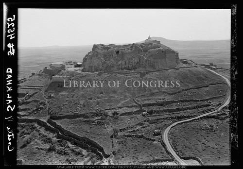
Castle of Salkhad. Closer view of the picturesque castle

It is a rich source of historical images of the Middle East. Though the majority of the items depict Palestine where the Colony and the Matsons were based, there are numerous historical photographs of Amman and other locations in Jordan, as well as other major centres in the Middle East. Of particular interest are the numerous aerial photographs taken - many on the Cairo to Baghdad Airmail Route.

The majority of the collection is in the Public Domain thanks to the original conditions of the donation. The fantastic digitisation program by the Library of Congress means you can access those images online: www.loc.gov/pictures/search/?st=grid&co=matpc.

We have gone through the collection and found the majority of the aerial photographs and created an individual set in our Flickr archive: http://www.flickr.com/photos/apaame/sets/72157635656377565/. Where not already known we have endeavoured to identify all of the sites in the photographs and georeference them. In addition to this you will find the Library of Congress online database reference information. In this Flickr set we hope to highlight the part of the collection that is aerial photography, as well to those that depict archaeological sites. We have paid particular attention to the ruins of Amman, ancient Philadelphia.

For more information on the collection please go to the Library of Congress website: www.loc.gov/pictures/collection/matpc/about.html. If you wish to access the original photographs or want unwatermarked digital copies please visit the Library of Congress website. We have provided the reference numbers for the items and links to their item records for this reason. APAAME holds no rights to these images and merely wishes to add to the information held regarding them in the Public Domain.

Wednesday, 17 April 2013

Flight 20130414, Field Trip 20130416 - al-Muwaqqar

Cropped section of RAF Topographical photograph dated 14 September, 1948 showing Al-Muwaqqar before the modern village was built.
Looking at the site of Al-Muwaqqar on historical RAF photographs from the 1940s, we were puzzled by a rectangular dark shape that resembled the outline of a small reservoir, south east of the known desert castle and south-west of the known large reservoir. Overlaying the photograph in Google Earth allowed us to pin point a GPS coordinate to investigate from the air, which was done on our second flight of the season - 14 April, 2013.
Aerial photograph taken 14 April 2013 with features indicated. © APAAME_20130414_DLK-0013
During our flight we thought we did not find the site, suspecting it had since been built over or buried by time. We did see exposed walls and mosaics of a recently excavated site - possibly a mansion or bath building, which we did photograph (Mega-J 58371 'Mwaqer Mosaic House'). Upon a closer look at the photographs post flight, a large wall to the west of the 'mansion' was clearly evident. We had indeed found the site we were looking for - but was it a reservoir wall?
Exposed section of 'reservoir' wall. © APAAMEG_20130416_MND-0013.
'Mansion'? © APAAMEG_20130416_MND-0016.
A quick ride in the car east of Amman on the road towards Azraq enabled us to follow up what we had photographed. Indeed, the wall west of the 'mansion' was substantial, moreover, the possible evidence of waterproofing with cement was apparent - though ancient or modern we do not know. An associated double wall was just evident on the surface running off diagonally from the south-western corner of the structure to the north-west. The eastern extent of the reservoir was not readily apparent. The section of excavated 'mansion' next to it had a beautifully paved floor, at least three mosaics (one almost complete), and evidence of at least two building events - one with large square stone paving blocks, a later one of tile and mortar. The whole site unfortunately was being impacted by construction waste being dumped in the area, and was cut by a road, drain and the construction of a neighbouring house.
Aerial photographs taken by the AAJ in 1998 and 2008 (Click to enlarge).
We also visited Qasr al-Muwaqqar, an Umayyad Desert Castle now overlain by the modern town. This site had also been much impacted by modern use; new concrete houses have encroached on this site, and some of the vaulted rooms appear to have been converted into early modern houses (complete with traditional reed and mud roofs), much like what has occurred as Qasr Azraq. These houses are now used as livestock pens by local residents. Rubbish is also dumped on the site. Sandstone columns and a regularly paved floor attested to the Qasr's former glory. The numerous ornate column capitals from the site have long-since been removed, as has the stone water-gauge.
Goat pens at Qasr al-Muwaqqar.
© APAAMEG_20130416_DLK-0052.
Paving Qasr al-Muwaqqar.
© APAAMEG_20130416_REB-0026.


The large reservoir of el-Muwaqqar is visible from the road. The site has been restored and is functional - still half full from the season's rains.
Large reservoir at Al-Muwaqqar. © APAAMEG_20130416_DLK-0058.
All photographs from the flight and ground visit will be available on Flickr shortly. http://www.flickr.com/apaame/collections. Follow us at @APAAME on twitter for updates.

Thursday, 28 February 2013

Historical Imagery - Berlin

As you may have noticed, we use Google Earth quite often to investigate ancient sites and how the landscape and site has changed in comparison with historical imagery.

Google Earth has a tool button that allows you to see historical imagery (if there is any) of an area  - in many cases the imagery dates can differ just a few years, but the changes can be drastic with urban expansion, natural disaster and other impacts vividly changing a landscape in just a short period of time.

You can view a period in the slightly more distant past over Berlin, Germany, a period that is particularly poignant to many people living today. Google Earth has extended its historical imagery for the site of the city of Berlin to two phases of aerial imagery during (1943/1945) and post World War Two (1953). The overlay appears to be made from a mosaic of aerial survey photographs, probably created by the United States Army Air Force (USAAF) and/or Royal Air Force (RAF), or aerial photographs confiscated from the German Air Ministry after WW2. For example, the United States National Archives Collection of Foreign Records Seized includes the following:

242.9.4 Other air force records
Aerial Photographs (8,000 items): Target dossiers of sites in Europe, North Africa, and the Middle East, with each dossier consisting of a map, an overprinted aerial photograph, and a site description, 1938-44; aerial photograph studies relating to specific types of targets in the United Kingdom, France, and the USSR, 1940-44; aerial mosaics of coastal areas in the United Kingdom and France, 1942-43; aerial prints and anaglyphs of central Italy, 1943-44; and aerial photographs of North African and Mediterranean sites, compiled for the German X Air Corps war diary, 1941-44. <http://www.archives.gov/research/guide-fed-records/groups/242.html>
These Aerial Photographs are linked to the records for Topographical Maps (242.25 Cartographic Records (General) (1910-18, 1935-45), and therefore probably include survey photographs.

Using the Historical Imagery tool you can change between the two phases and see the change from ruined buildings and bomb craters, to cleared land and some rebuilding.
Berlin 1953. Large parcels of city blocks of bombed ruins have been cleared. Image: Google Earth. Click to enlarge.
The capitals of London, Paris, Warsaw and Rome have also been overlain with historical aerial imagery. London and large areas of the south-east of Britain use one phase of imagery in 1945, Paris with two phases of 1943 and 1949, Warsaw with pre-WW2 imagery of 1935, and one of 1945, and Rome dating to 1943. Other smaller centers include Dortmund, Hanover, Leipzig, Cologne, Frankfurt, Wiesbaden, Koblenz, Nuremberg, Regensburg, Dresden, Wroclaw, Gdansk, Hamburg and Lubeck to name a few also have black and white historical imagery overlays.

Friday, 8 February 2013

Slide Scanning - Samosata

We are currently digitising the APAAME slide collection of ground photographs, and I had the pleasure of completing the letter 'S' not that long ago.
'S' contained some beautiful sites in SYRIA, SABRATHA on the Mediterranean coast of Libya, and SARDIS in Turkey to name a few.
All of these sites are geoencoded in our database to allow for sites to be searched by location as well as by site name. When I was finding the geographical coordinates for SAMOSATA, I was surprised to come across this in Google Earth (having personally been unfamiliar with the site up until now).
Location of the ruins of Samosata beneath the Ataturk Dam in Turkey (click to enlarge).
Samosata, ancient city of Commagene, was flooded in 1991 with the construction of the Ataturk Dam, and the modern town of Samsat on the site was moved to the north on higher ground. The remains of the ancient tell, possibly the remains of a palace, can be seen here in the scanned slide, the photograph taken before construction of the dam. It had evidently become a playground for the local children of Samsat. The entire site is now at the bottom of Ataturk Dam.
Photograph taken on the tell of Samosata c1970s, the Euphrates River in the background. Photograph: David Kennedy (Click to enlarge).
Very little excavation occurred before the site was flooded. CORONA satellite imagery, freely available through the fantastic University of Arkansas' 'CORONA Atlas of the Middle East' reveals the extent of the ancient site - the walls c. five kilometers long, enclosing an area of roughly 200 hectares (500 acres). This ancient city was the capital of a prosperous Hellenistic kingdom that later flourished under the Roman Empire. This is evident when you provide some perspective: Samosata was roughly three times the size of Pompeii, and 50 percent larger than Londinium, the capital of Roman Britain (Kennedy 1998). Should excavations been carried out to a greater extent, finds may have revealed the wealth of the capital of the Commagene kingdom, its later prosperity under the Roman Empire and as home of the Legio XVI Flavia until the 3rd century AD before its gradual demise into obscurity.
Screen shot of Samosata from CORONA Atlas of the Middle East, University of Arkansas http://corona.cast.uark.edu/index.html#bbox=4282983,4509629,4292155,4514526
Due to the location of Samosata now under some 120m of water, these historical images are all that preserve the knowledge of the site for future generations - who may become keen Underwater Archaeologists to learn more of Samosata.

For more information on the site of Samosata and the flooding of archaeological sites by the construction of the Ataturk Dam: David L. Kennedy (1998) 'Drowned Cities of the Upper Euphrates', Saudi Aramco World 49.5 (Sept/Oct): http://www.saudiaramcoworld.com/issue/199805/drowned.cities.of.the.upper.euphrates.htm
To browse the CORONA imagery, please visit the CORONA Atlas of the Middle East: http://corona.cast.uark.edu/index.html

Tuesday, 18 December 2012

Publications - Historical Aerial Imagery in Jordan and the Wider Middle East

Hot off the press!
Robert Bewley and David L. Kennedy, 2013, 'Historical Aerial Imagery in Jordan and the Wider Middle East' pp. 221-242 in: William S. Hanson and Iona A. Oltean (eds) Archaeology from Historical Aerial and Satellite Archives, Springer: New York/Heidelberg/Dordrecht/London.
ISBN: 978-1-4614-4504-3

The book or eBook can be purchased from the Springer website: http://www.springer.com/social+sciences/anthropology+%26+archaeology/book/978-1-4614-4504-3

Tuesday, 31 July 2012

Hunting Aerial Photographs - Bodleian Library Oxford

rhodes house library, oxford
Rhodes House Library, Oxford. Photo from Flickr user 'idlethink' http://www.flickr.com/photos/idlethink/387238200/.


While here in Oxford on Sabbatical, my attention was drawn to a huge collection of c. 1.5 million aerial photos held in Rhodes House. They were acquired about 8 years ago and ultimately came from British government agencies operating in many parts of the former British Empire. Most are vertical survey photos, prints and generally of a very high quality. They have been very generally catalogued and organised in some 8000 (sic) boxes. Most are of parts of Africa and East Asia but there is a sizeable minority of c. 50,000 covering parts of Yemen (including Aden), Oman and Saudi Arabia. A separate visit will be needed to the Map Room of the Bodleian Library to consult the maps on which the photo runs are plotted.

-DLK

Wednesday, 25 July 2012

Greater Zarqa, Jordan

Google Earth Screen Capture of urban development near Zarqa, north-east of Amman, Jordan. Click to enlarge.
In our last blog post we mentioned the impact of the expansion of the urban areas of Amman. While cataloguing historical imagery in our collection today, I have stumbled upon a perfect example which I was able to overlay in Google Earth after a bit of difficulty finding the location due to the extent the landscape had changed.

The image above is dated 22 August 2011. It does not differ much from the imagery dated eight years earlier below.

Google Earth Screen Capture of the same area as above, dated September 2003. Click to enlarge.
Compare, however with this RAF photograph taken in 1951.
Aerial photograph layered in Google Earth. Photograph V13RAF612 28 June 1951. Click to enlarge.
The contrast between the two images, fifty years apart, shows that the landscape has completely been transformed by the modern urbanisation of greater Amman to the south and Zarqa to the north-east. This specific area is of interest due to the location of el-Hadid (see Kennedy, D.L. 2002, 'Qaryat al-Hadid: a 'Lost' Roman Military Site in Northern Jordan', Levant, 34: 99-110), which you can see pinned in the top right of the screen captures. In the area specifically covered by the RAF photograph, however, we can see no trace of built remains on the surface except fields along the Wadi Zarqa.

Thursday, 24 May 2012

Publications: Pioneers above Jordan

David L. Kennedy 2012 'Pioneers above Jordan: revealing a prehistoric landscape', Antiquity 86: 474-491.

Percy Maitland (centre) in Iraq c.1925 (Maitland Family Collection).

Aerial photography is so fundamental an instrument of modern archaeology that we often take it for granted. But its methods are surprisingly specific and its most important experimental theatre was probably the territory of the Levant—and especially the rocky terrain of Jordan. The author, a prominent aerial archaeologist of our own day, takes time off to review the achievements of the pioneers, serving officers who established routes over the desert to deliver mail between Egypt and Iraq. The fabulous ancient landscape they discovered could only be appreciated through the lowlevel window provided by these slow-moving rickety machines and their intrepid pilots. In these days of jet travel, the precious basalt landscape is in danger of slipping off the agenda again—both for researchers and conservers.

Full text: Antiquity.co.uk