Showing posts with label Jordan. Show all posts

Monday, 7 January 2019

Enter the U2 Spyplane Aerial Photography

Even if you are not old enough to remember the shooting down of Gary Powers and the huge international crisis that followed in 1960, you may have seen the more recent movie Bridge of Spies (culminating in the exchange of Powers for a Soviet spy).

A few years ago, while at a conference, Jesse Casana told me that U2 aerial photos of 1958-1960 had now been declassified and included aerial photos – not the satellite photos of the Corona programme and its successors, of parts of the Middle East. Declassified but not catalogued and hard to actually access.

Emily Hammer and Jason Ur have created a spatial index to the declassified U2 Aerial Photos for the Middle East available in the National Archives (NARA), and this can be accessed at https://scholar.harvard.edu/jasonur/u2-aerial-photography-middle-east

At least one product of that work has now been published (Hammer and Lauricella 2017) – though not by Jesse Casana. It is plainly a laborious task still to use the material but the quality is very good and – of particular interest to me, is a flight of 1960 down the Jordanian panhandle from east to west and over and beyond Azraq. The Hunting Aerial Survey of 1953 is a little earlier in date but the quality is evidently poorer and it did not extend much east of Azraq. There will be particularly useful work to be done on that key area west of Azraq where the HAS material is very useful but poor quality combining it with the better U2 material of parts of the area. It is precisely there – with better quality soils and more precipitation, that the expansion of agriculture and removal of the basalt covering has damaged and destroyed many hundreds of sites of all kinds. As we know from our AAJ project, it is often difficult today to find traces of even the large Kites visible on the Hunting photos of 1953 and many have gone entirely.

Hammer, E. and A. Lauricella. 2017. “Historical Imagery of Desert Kites in Eastern Jordan.” NearEastern Archaeology 80.2: 74-83. Available on JSTOR.
Hammer, E. and J. Ur. In press. “Near Eastern Landscapes and Declassified U2 Aerial Imagery.” Advances in Archaeological Practice.


-DLK

Tuesday, 13 June 2017

A new use for the Blackhawks.


HRH Crown Prince Al Hussein bin Abdullah II during an aerial tour in Jordan’s skies over the Dead Sea.

Sunday, 26 March 2017

An Unexpected Commemoration of the Tapline


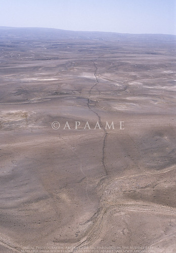
A regular sight while flying over the Harret al-Shaam in Jordan is the ruler-straight line of the road running alongside the long-defunct Trans-Arabian Pipeline which carried fuel from Saudi Arabia to Sidon in Lebanon from 1950 till – for its section into Jordan, 1990.

As the photo shows, the Tapline road and pipe often cut through ancient structures - in this case it is Ausaji Kite 31.


An unexpected reminder can be found in New York where the High Line Walkway/ Park – a 1.45 mile disused elevated section of an old railway line in west-central Manhattan, includes open-air art.


In this case it is a series of engraved rings welded to the old rail lines, each commemorating a section of the Tapline.

Saturday, 4 March 2017

Winged Crusaders and RAF's 14 Squadron in Jordan

I corresponded with the author several years ago and he kindly sent drafts of a couple of chapters covering 1915 to 1945 but I then missed that he had published the book. Now available in hard copy or as Kindle download. No 14 was the sole RAF squadron in Transjordan between the wars and carried out several programmes of aerial photography.

Napier, M. (2013) Winged Crusaders: The Exploits of 14 Squadron RFC & RAF 1915-45, London (Pen & Sword Books Ltd)


Thursday, 29 September 2016

FL201609 - September’s season so far. The Unexpected.

There is no question that the word “unexpected” is the theme of this year’s season, which has been very successful so far.  Unexpected length of annual holidays and holidays for parliamentary elections, and unexpected (and sometimes inexplicable) restrictions on when and where we can fly. None of this is a surprise; after 20 years of working in Jordan the plans we make before we arrive are always changed, but to the eternal credit of the Air Force, pilots and crews, we always achieve the vast majority of what we plan.
Landscape of the Wadi Araba, north of Aqaba. David Kennedy, APAAME_20160918_DLK-0399.
Our opening expedition (18-19 September) was south to Aqaba, but with the unexpected delay following the return to work after the Eid al-Adha, a stronger than expected headwind, and a sick crew man. However despite this we succeeded in flying for over 5 and a half hours, and still had just enough time at the end of the day for a therapeutic swim in the Red Sea, before flying a full four hours back to Amman the following day.
Wadi an Nasifah. Robert Bewley, APAAME_20160919_RHB-0117. 
Expected, but always surprising, is the number and nature of landscapes and sites we photograph. The trip home from Aqaba took us through narrow steep-sided gorges, with strategically located Roman military installations though to dramatic and contrasting geological formations with a variety of prehistoric, Roman and early Islamic sites.
A village on the southern edge of the Ras en-Naqb. Robert Bewley, APAAME_20160919_RHB-0161.
After a brief respite we had two excellent days in the black basalt desert (the Badia) photographing a wide range of sites. The one site that stood out for me - the “Bulls-eye” Cairn. I don’t remember seeing them as clearly defined as those we surveyed this year. The “Bulls-eye” Cairn is another example of just how little we know about the date, distribution or function of many of these sites. However the information we have accumulated means we can start to analyse them, and answer research questions.
A large 'Bulls-eye' cairn with tail, known also as a 'Pendant'. Robert Bewley, APAAME_20160922_RHB-0538.
As with the work of the National Mapping Programme in England, the contribution of aerial survey and interpretation has been to expand our understanding of the size and nature of the past human populations. Seeing the density of stone structures of all types, representing settlements, hunting sites, and burials, has to mean that in the majority of prehistory there were a sizeable human population in the badia desert region of Jordan. An area, until recently, which has been ignored by archaeologists, looking for richer pickings in the so-called Fertile Crescent; thankfully this is changing and there a number of expeditions working in this region to discover the nature of the sites, their date and function. You can see an example of the contribution of aerial survey in the Badia in this article about Bernd Müller-Neuhof's research: 6,000-year-old Fortresses Found in Jordan Show Surprisingly Advanced Early Society.
Concentration of features on the summit of 'Tell el-Ghusein'. Robert Bewley, APAAME_20160922_RHB-0604. 
It is always an exciting event to be flying in the rift valley along the shores of the Dead Sea, where our fifth flight was located. I don’t usually have the time or inclination to check the altimeter on the GPS but for some reason I clicked on it as we descended from 5,000 ft amsl (above mean sea level) to minus 500 ft, below it.
Our GPS reading -194 feet below mean sea level.
Most fittingly, we were flying over the Museum at the Lowest Place on Earth. This, of course, should be impossible without going under water, but as it is a “mean sea level” which gives us our height, there has to be exceptions. The Dead Sea area as the lowest point on earth (not under water) is one such exception, so we had the unexpected pleasure of flying along at minus 500ft, with the door open and a wonderful (warm) view of this part of the great rift valley.
View of the Rift Valley. Rebecca Banks, APAAME_20160927_REB-0072.
We were also, unexpectedly, approached by a journalist from Associated Press (AP), based in Amman. He has interviewed both David Kennedy and I, and I took him flying for a short trip to show the preparation and process of aerial survey. We look forward to seeing his short film in due course. On this short flight we also had (pre take-off) the unexpected pleasure of a flat battery in the helicopter; external power was wheeled in and we were on our way without much delay.

We are now using a different helicopter, no longer the Huey, but now the Eurocopter or ‘EC’. This has meant getting to know a new squadron, and new pilots. Each day it is a new crew. Sitting having tea after one sortie, high up in the control tower of one of airbases the Captain unexpectedly asked me, slightly reluctantly, “Why are you doing this work?” Behind the question (given a certain lack of interest up to that point) was the inference “it seems to be a complete waste of time.” I explained our reasons, - discovering sites, monitoring change and damage, and making a photographic record. On the next sortie he was able to the see sites in a new light and his orbiting was much more precise. Unfortunately we had another 4 hours of flying and by the end of it the crew were exhausted (as were we) and any positive feelings to archaeology were forgotten for the day.

We have had enthusiastic crew members taking pictures out of the window of archaeological sites and the beautiful Jordanian landscape (and maybe their home villages), but also unexpectedly many, many photographs on the ground, including “selfies.” I am not an enthusiast of the “selfie” phenomenon. I have been surprised by the sophistication of the “selfie world” with extending selfie sticks, the use of sun and shade, and location: a selfie with the helicopter in the background must clearly carry some weight in the purpose for which these photographs are taken (if indeed there is one). Who knows, one day we might even have a selfie album on APAAME, but I hope not.
The dreaded 'selfie stick'.
Unexpectedly our own health came into play to a greater degree than ever before. Aerial reconnaissance requires strength of both body and mind. The weaker either one of those is the stronger the other has to be. It is rare, here, to have full strength in both, either through lack of sleep (dogs barking in the night, the 0400 call to prayer all contributing to short nights) or the after effect of something we’ve eaten, having a devastating effect on one’s digestion. Each member of the team has succumbed, one way or another, to a bug. This has never happened before and we hope for all our sakes it doesn’t happen again.  Fortunately, so far, it has not affected the performance of our well planned (with unexpected changes) flying and making new discoveries.

Less than a week to go, so let us hope for less of the unexpected.

Bob Bewley
28th September 2016

Tuesday, 14 June 2016

AAJ May 2016 - Highs, Lows, and Goodbyes to the Hueys

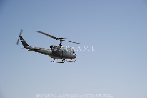
When we are in Jordan we will squeeze in any opportunity to fly, but this year it was particularly important to do a few flights as we have sadly lost the use of the wonderful beast of helicoptering - the Huey, and we had to test our new machines and pilots of the Eurocopters.
Jafr AFB
One of the RJAF Hueys in flight during the 2010 season. Photographer: Don Boyer. APAAME_20101016_DDB-0045.
The Huey has been our principal form of aerial reconnaissance since the Aerial Archaeology in Jordan project started in 1997. The advantages of the Huey were its spacious interior, large opening (once the door was open) and outward facing seats that allowed four photographers to operate together. Given these machines had been in operation during the Vietnam War (see our blog 'I Love the Smell of Nabataea in the Morning'), and one had a bullet hole to prove it, we knew we would have to move on eventually. They had their quirks, like the communication systems being flakey, shaking you about so that you could feel the movement for several hours after landing, and the noise! We felt a pang of grief for the loss of a trusted friend that had transported us over the varied sites and landscapes of Jordan. If anyone has a few million pounds to service a small fleet of Hueys for us, I am sure we could make good use of it!

Saturday, 28 May 2016

Flight 20160526 - East into the Badia

The second flight of the 2016 season saw Becc and I heading east to the Azraq area, taking in Qasr Aseikhim, a wonderful and significant multi period hilltop site but which is suffering badly from the bulldozer as access roads make it more accessible.
Qasr Aseikhim showing signs of damage from bulldozing. Photographer: Rebecca Banks. APAAME_20160526_REB-0132.
We then headed to assess the impact of the construction of the Azraq by-pass on the stone built structures on the Harrat al-‘Uwaynid. It was truly depressing seeing what had been destroyed without thorough investigations (a presentation at ICHAJ13 by Romel Garib said a survey had been conducted with the help of Prof. Gary Rollefson, but no excavation); truly a missed opportunity as the area is rich in kite-sites, wheels, and pendants (one of which we have been monitoring and has had its tail smashed through – seemingly unnecessarily). These sites are representative of this part of the basalt plateau, and we know so little about them.

Friday, 27 May 2016

FL20160523 - Clouds in the North

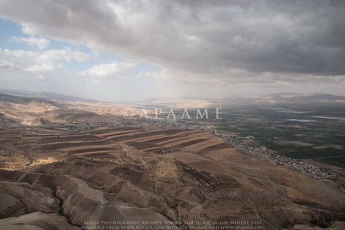
The Aerial Archaeology in Jordan project has just begun its 20th season (after David’s flight in 1997) and it coincides with ICHAJ13- a conference to celebrate and be informed of recent archaeological work in Jordan. Balancing the commitments of the conference with trying to fly was always going to be tricky but the opportunity to undertake aerial surveys should never be missed, especially in this region.

Jordan Valley; Tabaqat Fahl
Jordan Valley near Pella. Low cloud made visibility and photography not ideal. Photographer: Robert Bewley. APAAME_20160523_RHB-0219.

Jordan never ceases to surprise, and this year has seen the demise of the Air Force’s Huey helicopters, which we had come to love – despite their the noise, and discomfort too, but also great space and views with the door open, and relatively slow speed. So, this first fight (Andrea Zerbini and I) was also experimental in learning the art of aerial photography in a new machine – the Eurocopter (or EC 635).

Wednesday, 24 February 2016

Publications: Khatt Shebib

Khatt Shebib
The Khatt Shebib. Photographer: Robert Bewley (APAAME_20051002_RHB-0069).
Recently the academic journal Zeitschrift für Orient-Archäologie published our article on the wall feature in Jordan known as the 'Khatt Shebib'. The content of this article was recently reported on by Owen Jarus in the online science website 'LiveScience' - '93-Mile-Long Ancient Wall in Jordan Puzzles Archaeologists'

The LiveScience feature has led to other media taking up the story. 

The feature was investigated remotely in the course of the active aerial reconnaissance program - the Aerial Archaeology in Jordan project, as well as visited on the ground. The study utilised historical imagery (mainly 1953) and maps, as well as several archaeological survey reports conducted on different sections of the wall, notably those directed by B. MacDonald (Wadi el-Hasa, Tafila to Busayra, and Ayl to Ras an-Naqab Archaeological Surveys), F. Abudanh (in the region of Udruh) and G. Findlater (the Dana Archaeological Survey).

You can find the tagged images of the Khatt Shebib on our Flickr page by following this link.

The synthesis of the information gathered has potentially raised more questions than those that we were able to answer, and we hope this study will soon be followed up by a comprehensive ground investigation of the entire feature and sites directly associated with it which may be dateable.

David Kennedy & Rebecca Banks 2015. 'The Khatt Shebib in Jordan: From the Air and Space', Zeitschrift für Orient-Archäologie 8: 132-154.

Thursday, 7 January 2016

Jordan Times article reports damage to the Via Nova Traiana

Ammar Khammash recently wrote an opinion piece in The Jordan Times regarding damage to a major monument in Jordan from the Roman period - The Via Nova Traiana ('Ancient Rome Reawakened', The Jordan Times, 27 December 2015: http://www.jordantimes.com/opinion/ammar-khammash/ancient-rome-reawakened).

This great Roman highway was constructed soon after the annexation of the Nabataean kingdom in AD 106 and – as some of its milestones declare, Rome – under the Emperor Trajan, had ‘redacta in formam provinciae Arabia viam novam a finibus Syriae usque ad Mare Rubrum” (“turned Arabia into provincial form and built a new road from the boundaries of Syria as far as the Red Sea”). Hence the modern description of it as the Via Nova Traiana.

Jimal VNT
A stretch of the Via Nova Traiana near Umm el-Jimal. APAAME_20060911_DLK-0290. Photographer: David Kennedy.
The road begins at Bostra in southern Syria then traverses Jordan from west of Umm el-Jimal in the north to Aqaba in the south. Though it bears the name of the Emperor Trajan, it is generally thought the road made use of earlier thoroughfares through the landscape, and its milestones are testament that it continued to be used well after, to the extent that sections of it are beside or underneath modern stretches of road. Well-preserved sections of the ancient road are increasingly difficult to find as development in Jordan continues at speed with the many pressures of increased demographics and modern infrastructure. In some places the road can be found complete with its paved substructure, in others only a side kerb of stones survives and paving may have never been laid; many sections are completely lost.

Due to his previous research regarding the course of the road through the landscape, Khammash reports that he met the news of the new wind farm in the Tafila Governorate with trepidation, and his visitation to the area confirmed his fears. He found that the road was cut in several places by the earthworks, platforms and access roads for the network of towers.

Khammash specifically reports that the Via Nova Traiana is directly intersected by the construction of turbine WTG 32. The Final Report for the proposed wind farm states that 'No Archaeological Remains' were found at this location (Table 13-2). Khammash also reports intersections or cuts in the vicinity of turbines WTG 26, 29 and 38. The first of these is also reported as having 'No Archaeological Remains' while the other two locations are from relocations to avoid other archaeological sites.

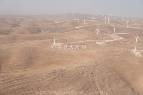
By chance, the Aerial Archaeology in Jordan Project flew in the vicinity of the wind farm in transit to and from sites planned for the 5th flight of its 2015 season. Dr Robert Bewley captured the site of Kh. ad-Dabbah (JADIS:2101035; MEGA-J:4804) in passing. What you can just see in the image is the traces of the Via Nova Traiana extending from the right of the site of Kh. ad-Dabbah in the foreground to the platform of the wind farm in the middle distance.

The Final Report documents that of the proposed 38 locations for wind turbines, 16 were changed due to concern for archaeological material (Table 13-2). Consultations and site visits through April until September of 2012 are listed in the documentation (Tafila Wind Farm Environmental and Social Impact Assessment, Stakeholder Engagement Plan, Table 3-1). Nowhere in the documentation is knowledge of a Roman road mentioned.

The Executive Summary for the then proposed wind farm states:
"...Where historical monuments were found, the locations of the turbines and the roads were revised. 
Even though the wind farm is planned in such a way that no historical artifacts are impacted, excavation works during the project construction might reveal further archaeological remains. Thus every effort must be made during construction to prevent damages on any findings."
Tafila Energy Project, Tafila Goverorate (Hashemite Kingdom of Jordan) Executive Summary, Report No. 11-1-3058f, CUBE Engineering GmbH, Al-Rawabi Environment & Energy Consultancies, 20th December 2012: 9.
The literature survey may perhaps be indicative of how the knowledge of the major Roman Road did not come to mind of the surveyors: two of the major archaeological surveys conducted in the area are not mentioned in the documentation - The Tafila-Busayra Archaeological Survey and the Dana Archaeological Survey as well as a survey conducted by Prof. Zbigniew Fiema which exists as a report in the Department of Antiquities. Also of note is that nowhere could I find in the assessment documentation reference to the current SMR for Jordan - MEGA-J, only its outdated predecessor, JADIS.

No comprehensive map of the distribution of these sites over the extent of the proposed wind farm is provided despite mention in passing in the Environmental and Social Mitigation Plan of numerous archaeological sites over the proposed area, a conducted survey, and consultation of aerial map surveys and experts in the field (Section 11.1). This is despite profuse inclusion of other GIS analyses in the project assessment, including a distribution of the 'best known' archaeological sites in the region which were assessed for indirect impacts.

It is clear that this international funded project for renewable energy in Jordan has done an assessment of the direct and indirect impacts of the project on the archaeological landscape and made alterations to their plans to best accommodate what they knew of the archaeological and heritage environment. So how did the major thoroughfare of this part of the Roman Empire escape inclusion in their assessments?

Is it simply a case that something as slight as a row of kerb stones was overlooked, or not considered substantive enough to warrant remark? An act of unconscious archaeological snobbery where a built structure is considered but a surface feature is dismissed? The reports do not tell us if the road was successfully investigated if it was discovered over the course of the construction of the wind farm. The Environmental and Social Mitigation Plan implies that his would be the case, and we for one hope there is an archaeological report on the excavation of a section of the Via Nova Traiana forthcoming. If not, we join Ammar Khammash in hoping that this destruction may highlight the importance of documenting and preserving where possible what is left of this ancient monument.

All assessment documents for the Tafila Wind Project were accessed through the International Finance Corporation website:
Tafila Wind Environmental and Social Review Summary, http://ifcext.ifc.org/ifcext/spiwebsite1.nsf/vwAllDocumentsByUNID_NL/1E151BC4ED5004B885257AF7006F1151?opendocument, accessed 5 January 2016. Hyperlinks have been provided throughout the text.

Aerial Archaeology in Jordan Project's images of the wind farm taken in 2015 can be found on the APAAME Flickr page. Other numerous aerial (and a number of ground) photographs of other stretches of the Via Nova and sites along its length can be found on the Flickr web site for APAAME by searching for “Via Nova Traiana” or “VNT”.

Published surveys mentioned in this text:
Findlater, George Macrae. 2003. Imperial control in Roman and Byzantine Arabia: a landscape interpretation of archaeological evidence in southern Jordan, PhD Thesis The University of Edinburgh: Appendix 1 Gazetteer of Archaeological Sites of the Dana Archaeological Survey.
MacDonald, B., Herr, L.G., Neeley, M.P., Gagos, T., Moumani, K., and Rockman M. 2004. The Tafila-Busayra Archaeological Survey 1999-2001, West-Central Jordan, American Schools of Oriental Research, Boston, MA.

Saturday, 10 October 2015

FL20151005-06 - Migrating south for the archaeology

One of the purposes of our aerial reconnaissance in Jordan is to cover places we haven’t flown before as well as to monitor sites we may have photographed a few years ago. We also respond to requests for targets to be photographed. With all this in mind we organised a two-day trip to stay overnight in Aqaba on the Red Sea, flying from the air base in Marka (Amman).
An example of one of the impressive landscapes we were treated to. APAAME_20151005_REB-0152.
We flew down to the Tafilah-Kerak area, recording many stone-built sites and villages, and of course the odd Roman road, and crossing the very impressive Wadi al-Hasa and Wadi ad-Dana. However the light was not great, until about 8 o’clock, as the weather was on the change. The landscape did its best to distract us from the archaeology- except where the two went hand in hand such as the Iron Age site of Shag Rish dramatically perched above the Dana Nature Reserve to the south.
The Iron Age site of Shag Rish. APAAME_20151005_REB-0134.
We had to refuel at the desert oasis of Al-Jafr and en route spotted an archaeological excavation (in the middle of nowhere), which we presume to be part of the Japanese expedition exploring neolithic sites (Directed by Dr. Sumio Fuji). Arrival at Al-Jafr was a first for our co-pilot, who, despite having been in the RJAF for 6 years had never tasted the delights of Al-Jafr. Courtesy of a small convenience store the pilots indulged us with some Chocolate Milk before we headed south-east to record sites on the high plateau before dropping down into the Wadi Araba.
Excavations north-west of Al-Jafr. APAAME_20151005_DLK-0085.
We had the unexpected bonus of a reasonably high-level flight over Petra (gone are the days when we could descend in the helicopter to take close-ups of the tombs, but look at the photos from 1998 (Flickr album Flight 19980520)).
Petra. APAAME_20151005_DLK-0426.
Jordan was having a warm spell and Aqaba was 37 degrees, and as we were informed as we arrived at the hotel, the sea temperature was 26 degrees. Water has to be that warm to entice me in and very refreshing it was. Drying off on the beach I was joined by our crew-man, who spoke good English and asked why we always photograph the same sites (as he has been on many trips with us). I explained that we didn’t but that we fly very similar areas as there are so many sites, often very close together. He then asked if the sea was "perfidious". I struggled for an answer, but said that if he meant treacherous then yes, but we wouldn’t necessarily use “perfidious” for the sea.
The landscape of Wadi Rum. APAAME_20151006_REB-0013.
The next day was one of the rare days when not only is the archaeology stunning, so was the scenery and the flying. We literally climbed the hills out of Aqaba to the east (and slightly north), and emerged (having dodged a few clouds) into the Wadi Rum. It doesn’t matter which way we looked, into the hazy sun, or with the sun behind us, the scenery was quite enthralling.

The archaeological site of Wadi Rum. APAAME_20151006_REB-0026.
We then aimed for the Hejaz railway to continue where we had left off the previous year, helping the Great Arab Revolt Project (GARP) with its surveys; many Ottoman installations and tent circles are clearly visible. The isolated Hajj Fort of Qal'at Fassu'ah was also a highlight.
Qal'at Fassu'ah. APAAME_20151006_DLK-0097.
An extended break between sites along the Hijaz saw our pilots give us an example of their idea of flying. The pilots decided that the helicopter was a train and they flew at low-level above the tracks making “chuff-chuff” noises. Bored with this, and seeing that the main road to Saudi Arabia adjacent to the railway they decided to pretend to be a lorry, on the wrong side of the road; all the while reassuring us that the oncoming lorry drivers were laughing and waving, thinking how much fun this was for them. We do now have some very “low-level obliques” of vehicles not many feet away.
A lorry driver waving as we flew by. APAAME_20151006_RHB-0137.
We were glad of a pit-stop at Al-Jafr to regain some composure after such 'interesting' flying, and refuel for the helicopter and ourselves, consisting of dates and digestive biscuits sitting in the shade of the Huey.
Qasr Mesheish. The damage, probably done for the building stone, is clearly evident. APAAME_20151006_DLK-0347.
The final leg heading north back to Amman took us to a site Sir Aurel Stein had photographed in the 1930s, Qasr Mesheish – the site was visited by both Musil and Glueck, but has not been researched since to our knowledge. Their opinion was it may have Nabatean origins, perhaps a caravanserai. There are clearly other features nearby, a structure or enclosure with tower, as well as cisterns, and a later(?) cemetery. Unfortunately, the site is clearly suffering extreme damage. Our final target for the day was over the caravanserai of Khan es-Zabib.

The secondary structure at Qasr Mesheish - a tower within a larger enclosure. APAAME_20151006_DLK-0350.
Tired but invigorated after a very special and privileged two-day reconnaissance over southern Jordan, we drank tea (or coffee) with the flight commander to plan the next day’s flight, over the Greater Amman area.

- Robert Bewley and Rebecca Banks

Monday, 11 May 2015

Sir Alexander Kennedy (17 March 1847 – 1 November 1928)

Sir Alexander Kennedy
At the time of his first visit to Petra in 1922, Sir Alexander Kennedy was 75 years. The visit certainly made an impression on him as he arranged to return the following year to spend a month there in studying its history and antiquities.   Although he was not an archaeologist by trade (he was senior partner of an engineering firm) – he was one of those early pioneers quick to recognise the importance of aerial photography to archaeologists in attempting to understand the landscape setting, as well as the distribution and range of sites (Bewley & Kennedy 2013: 231). Kennedy lamented the lack of a thorough scientific study of the area around Petra. Of the early visitors who came after Burckhardt in 1812, many of whom were unable to remain for much more than two or three nights, he observed that “…although many published their experiences, practically nothing of scientific value resulted from their visits” (Kennedy 1924: 273).

In a talk he later gave to the Royal Geographical Society, Kennedy gives an insight into what may have driven him to devote his energy to further study of Petra – he considered Musil’s second volume of Arabia Petræa to contain the “first map which possessed any value”, and then Brünnow and Domaszewski’s maps made from their visits in 1897 and 1898 to be the most accurate. He praised their work, however, he observed omissions and guesswork - “the irregularity and roughness of the ground make it extremely difficult to cover every square yard of some 6 or 8 miles; but nothing less would be for any investigation to be entirely exhaustive” (Kennedy 1924: 274).

During his second visit to Petra in 1923, Kennedy, despite his advanced age was busily engaged in mapping and photographing the area in detail. Towards the end of the season Kennedy suffered a stroke, from which he is reported to have recovered rather quickly. Despite the physical strain of the work, he again ventured to continue his study of Petra in 1924, “having at his own expense arranged with the Air Force for a complete aerial photographic survey of the whole area”
Philby (1948: 216) recalls;
“I worked with him on the ground again, and the result was a splendid, profusely illustrated volume called Petra, to which I wrote a foreword, descriptive of the country and its people. It was a remarkable feat for a man, who had never been in the East before, to perform between his seventy-sixth and seventy-eighth years.”

Kennedy’s securing of the services of the RAF squadron at Amman enabled a vertical survey of a wide area around the city centre to be taken - an area covering c.85km2
For an audience familiar with ground views, but unable to visualise the context and landscape, this would have been revelatory. But it was more than a novel view or general photomap; Kennedy evidently examined closely those frames that covered the central area of the city.” (Bewley & Kennedy 2013: 231)
The air-plane view shows also very distinctly the lines of the Roman streets and the outlines of some of some of the principal buildings or places, and many other points quite unrecognizable on the ground. (Kennedy 1924: 278-9). 


Oblique view of Wadi Musa, Petra - Kennedy (1925) Source: Wikimedia Commons.

Bewley, R. & Kennedy, D. (2013). Historical Aerial Imagery in Jordan and the Wider Middle East, in: W. S. Hanson & I. A. Oltean (eds) Archaeology from Historical Aerial and Satellite Archives. London: Springer: 221-242.
Kennedy, A. B. W. (1924). The rocks and monuments of Petra. The Geographical Journal, 63.4: 273-295.
Kennedy, A. B. W. (1925). Petra. Its history and monuments. London: Country Life.
Philby, H. StJ. B. (1948). Arabian Days. An autobiography. London: Robert Hale Limited.