 |
| The Madaba Martyrs Church, section of Roman Road and the 'Burnt Palace'. Photographer: Robert Bewley. APAAME_20160529_RHB-0017. |

Showing posts with label site destruction. Show all posts
Showing posts with label site destruction. Show all posts
Thursday, 9 June 2016
FL20160529 - Low clouds over the Kerak Plateau
Aiming for a 7 o’clock take off we left CBRL at 0630, Andrea and I, with the sun rising and some clouds in the west. As we crossed the Hejaz railway en route to Marka we were overtaken by the Squadron Commander, who waved and we followed him; I was wondering which gate to the air base he’d use (as there is more than one). Every year we have gone through a ritual at the gate where the guards don’t have a clue who we are, despite assurances the previous day that the guards have been informed. Today we followed him through a gate we knew existed but have never used; this is the gate where we have been supposed to enter - the gate where the guards have been forewarned each day (by the squadron commanders) prior to arrival. As it was our last day of the season we will not know if we will have “cracked” the gate until September, when we hope to return.


Thursday, 7 January 2016
Jordan Times article reports damage to the Via Nova Traiana
Ammar Khammash recently wrote an opinion piece in The Jordan Times regarding damage to a major monument in Jordan from the Roman period - The Via Nova Traiana ('Ancient Rome Reawakened', The Jordan Times, 27 December 2015: http://www.jordantimes.com/opinion/ammar-khammash/ancient-rome-reawakened).
This great Roman highway was constructed soon after the annexation of the Nabataean kingdom in AD 106 and – as some of its milestones declare, Rome – under the Emperor Trajan, had ‘redacta in formam provinciae Arabia viam novam a finibus Syriae usque ad Mare Rubrum” (“turned Arabia into provincial form and built a new road from the boundaries of Syria as far as the Red Sea”). Hence the modern description of it as the Via Nova Traiana.
The road begins at Bostra in southern Syria then traverses Jordan from west of Umm el-Jimal in the north to Aqaba in the south. Though it bears the name of the Emperor Trajan, it is generally thought the road made use of earlier thoroughfares through the landscape, and its milestones are testament that it continued to be used well after, to the extent that sections of it are beside or underneath modern stretches of road. Well-preserved sections of the ancient road are increasingly difficult to find as development in Jordan continues at speed with the many pressures of increased demographics and modern infrastructure. In some places the road can be found complete with its paved substructure, in others only a side kerb of stones survives and paving may have never been laid; many sections are completely lost.
Due to his previous research regarding the course of the road through the landscape, Khammash reports that he met the news of the new wind farm in the Tafila Governorate with trepidation, and his visitation to the area confirmed his fears. He found that the road was cut in several places by the earthworks, platforms and access roads for the network of towers.
Khammash specifically reports that the Via Nova Traiana is directly intersected by the construction of turbine WTG 32. The Final Report for the proposed wind farm states that 'No Archaeological Remains' were found at this location (Table 13-2). Khammash also reports intersections or cuts in the vicinity of turbines WTG 26, 29 and 38. The first of these is also reported as having 'No Archaeological Remains' while the other two locations are from relocations to avoid other archaeological sites.
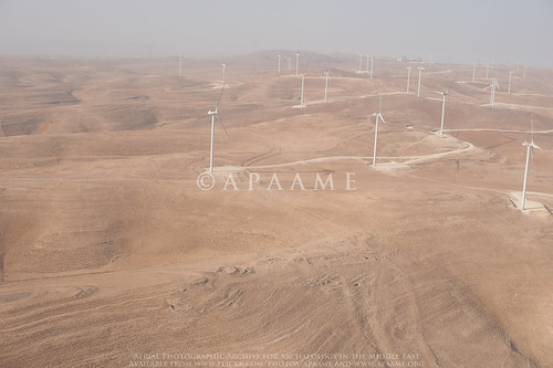
By chance, the Aerial Archaeology in Jordan Project flew in the vicinity of the wind farm in transit to and from sites planned for the 5th flight of its 2015 season. Dr Robert Bewley captured the site of Kh. ad-Dabbah (JADIS:2101035; MEGA-J:4804) in passing. What you can just see in the image is the traces of the Via Nova Traiana extending from the right of the site of Kh. ad-Dabbah in the foreground to the platform of the wind farm in the middle distance.
The Final Report documents that of the proposed 38 locations for wind turbines, 16 were changed due to concern for archaeological material (Table 13-2). Consultations and site visits through April until September of 2012 are listed in the documentation (Tafila Wind Farm Environmental and Social Impact Assessment, Stakeholder Engagement Plan, Table 3-1). Nowhere in the documentation is knowledge of a Roman road mentioned.
The Executive Summary for the then proposed wind farm states:
No comprehensive map of the distribution of these sites over the extent of the proposed wind farm is provided despite mention in passing in the Environmental and Social Mitigation Plan of numerous archaeological sites over the proposed area, a conducted survey, and consultation of aerial map surveys and experts in the field (Section 11.1). This is despite profuse inclusion of other GIS analyses in the project assessment, including a distribution of the 'best known' archaeological sites in the region which were assessed for indirect impacts.
It is clear that this international funded project for renewable energy in Jordan has done an assessment of the direct and indirect impacts of the project on the archaeological landscape and made alterations to their plans to best accommodate what they knew of the archaeological and heritage environment. So how did the major thoroughfare of this part of the Roman Empire escape inclusion in their assessments?
Is it simply a case that something as slight as a row of kerb stones was overlooked, or not considered substantive enough to warrant remark? An act of unconscious archaeological snobbery where a built structure is considered but a surface feature is dismissed? The reports do not tell us if the road was successfully investigated if it was discovered over the course of the construction of the wind farm. The Environmental and Social Mitigation Plan implies that his would be the case, and we for one hope there is an archaeological report on the excavation of a section of the Via Nova Traiana forthcoming. If not, we join Ammar Khammash in hoping that this destruction may highlight the importance of documenting and preserving where possible what is left of this ancient monument.
All assessment documents for the Tafila Wind Project were accessed through the International Finance Corporation website:
Tafila Wind Environmental and Social Review Summary, http://ifcext.ifc.org/ifcext/spiwebsite1.nsf/vwAllDocumentsByUNID_NL/1E151BC4ED5004B885257AF7006F1151?opendocument, accessed 5 January 2016. Hyperlinks have been provided throughout the text.
Aerial Archaeology in Jordan Project's images of the wind farm taken in 2015 can be found on the APAAME Flickr page. Other numerous aerial (and a number of ground) photographs of other stretches of the Via Nova and sites along its length can be found on the Flickr web site for APAAME by searching for “Via Nova Traiana” or “VNT”.
Published surveys mentioned in this text:
Findlater, George Macrae. 2003. Imperial control in Roman and Byzantine Arabia: a landscape interpretation of archaeological evidence in southern Jordan, PhD Thesis The University of Edinburgh: Appendix 1 Gazetteer of Archaeological Sites of the Dana Archaeological Survey.
MacDonald, B., Herr, L.G., Neeley, M.P., Gagos, T., Moumani, K., and Rockman M. 2004. The Tafila-Busayra Archaeological Survey 1999-2001, West-Central Jordan, American Schools of Oriental Research, Boston, MA.
This great Roman highway was constructed soon after the annexation of the Nabataean kingdom in AD 106 and – as some of its milestones declare, Rome – under the Emperor Trajan, had ‘redacta in formam provinciae Arabia viam novam a finibus Syriae usque ad Mare Rubrum” (“turned Arabia into provincial form and built a new road from the boundaries of Syria as far as the Red Sea”). Hence the modern description of it as the Via Nova Traiana.
 |
| A stretch of the Via Nova Traiana near Umm el-Jimal. APAAME_20060911_DLK-0290. Photographer: David Kennedy. |
Due to his previous research regarding the course of the road through the landscape, Khammash reports that he met the news of the new wind farm in the Tafila Governorate with trepidation, and his visitation to the area confirmed his fears. He found that the road was cut in several places by the earthworks, platforms and access roads for the network of towers.
Khammash specifically reports that the Via Nova Traiana is directly intersected by the construction of turbine WTG 32. The Final Report for the proposed wind farm states that 'No Archaeological Remains' were found at this location (Table 13-2). Khammash also reports intersections or cuts in the vicinity of turbines WTG 26, 29 and 38. The first of these is also reported as having 'No Archaeological Remains' while the other two locations are from relocations to avoid other archaeological sites.
By chance, the Aerial Archaeology in Jordan Project flew in the vicinity of the wind farm in transit to and from sites planned for the 5th flight of its 2015 season. Dr Robert Bewley captured the site of Kh. ad-Dabbah (JADIS:2101035; MEGA-J:4804) in passing. What you can just see in the image is the traces of the Via Nova Traiana extending from the right of the site of Kh. ad-Dabbah in the foreground to the platform of the wind farm in the middle distance.
The Final Report documents that of the proposed 38 locations for wind turbines, 16 were changed due to concern for archaeological material (Table 13-2). Consultations and site visits through April until September of 2012 are listed in the documentation (Tafila Wind Farm Environmental and Social Impact Assessment, Stakeholder Engagement Plan, Table 3-1). Nowhere in the documentation is knowledge of a Roman road mentioned.
The Executive Summary for the then proposed wind farm states:
"...Where historical monuments were found, the locations of the turbines and the roads were revised.
Even though the wind farm is planned in such a way that no historical artifacts are impacted, excavation works during the project construction might reveal further archaeological remains. Thus every effort must be made during construction to prevent damages on any findings."
Tafila Energy Project, Tafila Goverorate (Hashemite Kingdom of Jordan) Executive Summary, Report No. 11-1-3058f, CUBE Engineering GmbH, Al-Rawabi Environment & Energy Consultancies, 20th December 2012: 9.The literature survey may perhaps be indicative of how the knowledge of the major Roman Road did not come to mind of the surveyors: two of the major archaeological surveys conducted in the area are not mentioned in the documentation - The Tafila-Busayra Archaeological Survey and the Dana Archaeological Survey as well as a survey conducted by Prof. Zbigniew Fiema which exists as a report in the Department of Antiquities. Also of note is that nowhere could I find in the assessment documentation reference to the current SMR for Jordan - MEGA-J, only its outdated predecessor, JADIS.
No comprehensive map of the distribution of these sites over the extent of the proposed wind farm is provided despite mention in passing in the Environmental and Social Mitigation Plan of numerous archaeological sites over the proposed area, a conducted survey, and consultation of aerial map surveys and experts in the field (Section 11.1). This is despite profuse inclusion of other GIS analyses in the project assessment, including a distribution of the 'best known' archaeological sites in the region which were assessed for indirect impacts.
It is clear that this international funded project for renewable energy in Jordan has done an assessment of the direct and indirect impacts of the project on the archaeological landscape and made alterations to their plans to best accommodate what they knew of the archaeological and heritage environment. So how did the major thoroughfare of this part of the Roman Empire escape inclusion in their assessments?
Is it simply a case that something as slight as a row of kerb stones was overlooked, or not considered substantive enough to warrant remark? An act of unconscious archaeological snobbery where a built structure is considered but a surface feature is dismissed? The reports do not tell us if the road was successfully investigated if it was discovered over the course of the construction of the wind farm. The Environmental and Social Mitigation Plan implies that his would be the case, and we for one hope there is an archaeological report on the excavation of a section of the Via Nova Traiana forthcoming. If not, we join Ammar Khammash in hoping that this destruction may highlight the importance of documenting and preserving where possible what is left of this ancient monument.
All assessment documents for the Tafila Wind Project were accessed through the International Finance Corporation website:
Tafila Wind Environmental and Social Review Summary, http://ifcext.ifc.org/ifcext/spiwebsite1.nsf/vwAllDocumentsByUNID_NL/1E151BC4ED5004B885257AF7006F1151?opendocument, accessed 5 January 2016. Hyperlinks have been provided throughout the text.
Aerial Archaeology in Jordan Project's images of the wind farm taken in 2015 can be found on the APAAME Flickr page. Other numerous aerial (and a number of ground) photographs of other stretches of the Via Nova and sites along its length can be found on the Flickr web site for APAAME by searching for “Via Nova Traiana” or “VNT”.
Published surveys mentioned in this text:
Findlater, George Macrae. 2003. Imperial control in Roman and Byzantine Arabia: a landscape interpretation of archaeological evidence in southern Jordan, PhD Thesis The University of Edinburgh: Appendix 1 Gazetteer of Archaeological Sites of the Dana Archaeological Survey.
MacDonald, B., Herr, L.G., Neeley, M.P., Gagos, T., Moumani, K., and Rockman M. 2004. The Tafila-Busayra Archaeological Survey 1999-2001, West-Central Jordan, American Schools of Oriental Research, Boston, MA.
Friday, 12 September 2014
Research: Qasr Ain el-Beidha
In c. 1981 David Kennedy visited Qasr Ain el-Beidha as part of his investigations into the archaeological traces of the Roman frontier in North-East Jordan. The site shows clearly on the Hunting Aerial Survey imagery of 1953 - a clear perimeter wall c.20m square with a collapsed square tower in the center.
Their survey of the site confirmed this:
It consists of a tower, 5.14m square, set within a walled enclosure 21 x 16.18m with, apparently, rounded corners. The tower is built of large blocks of basalt laid in regular courses, 3 of which may be seen and two others inferred. The surviving height of the 3 courses is 1.12m and the wall is 1.2m thick made up of blocks laid as headers and stretchers. Both tower and enclosure wall are much decayed and overlaid with rubble. The latter seems to have been no more than dry-stone built wall and there was only one point, on the S. side, at which evidence of the rough slabs being laid in courses was clear (Kennedy 1982 Archaeological Explorations on the Roman Frontier in North-East Jordan: 186-7).
In addition, Kennedy notes the lines of site from the tower to Qasr Azraq and Qazr Aseikhim, major Roman sites in the area. He concludes that the site likely acted as "an outpost to control access to a water-point" as well as a watch-tower on the route to Qasr Burqu (Kennedy 1982: 187).
Today, the site is lost except for a section of the perimeter wall. We were able to photograph what remains of the site in 2011. A bitumen road has been built since 1978 running east from Azraq straight through the site. Historical satellite imagery in Google Earth implies the road has been in existence since at least 2003. Photographs from the 1978 survey imply that the track had previously gone around the site.
 |
| HAS 11.008 overlaid in Google Earth - Qasr Ain el-Beidha is clearly visible on the basalt bottom right. Please click to enlarge image. |
It consists of a tower, 5.14m square, set within a walled enclosure 21 x 16.18m with, apparently, rounded corners. The tower is built of large blocks of basalt laid in regular courses, 3 of which may be seen and two others inferred. The surviving height of the 3 courses is 1.12m and the wall is 1.2m thick made up of blocks laid as headers and stretchers. Both tower and enclosure wall are much decayed and overlaid with rubble. The latter seems to have been no more than dry-stone built wall and there was only one point, on the S. side, at which evidence of the rough slabs being laid in courses was clear (Kennedy 1982 Archaeological Explorations on the Roman Frontier in North-East Jordan: 186-7).
 |
| Qasr Ain el-Beidha general view c. 1981. Image © David Kennedy. Please click to enlarge image. |
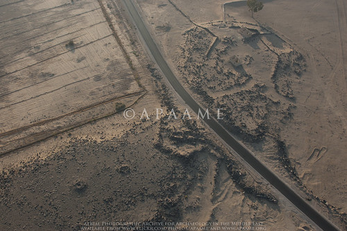 |
| Qasr Ain el Beidha photographed in 2011 - the perimeter wall can just be seen to the left of the road in the picture. APAAME_20111027_MND-0079. Please click to enlarge image. |
 |
| Qasr Ain el Beidha general view c. 1981. The track can be seen running around to the right of the site in the photograph. Image © David Kennedy. Please click to enlarge image. |
Subscribe to:
Posts (Atom)