Showing posts with label Azraq. Show all posts

Saturday, 25 October 2014

Filming in Azraq

Friday 24th October. Up before sunrise, left Amman with a film crew and headed east to Azraq.

David Kennedy on the Umayyad reservoir wall - Azraq Wetland Reserve.
The day began with some shooting at Azraq Wetland Reserve. While there we took the opportunity to photograph the Umayyad reservoir wall. Sadly the oasis has greatly diminished in size in the last twenty years. Despite the Water authority pumping 1.5 to 2.5 million cubic metres of water into the wetlands each year, it is not enough to replenish the excessive pumping of water out of the oasis and, sadly, it is still shrinking in size.

Filming at Azraq Wheel 82
From there we headed out into the basalt desert to visit a Wheel and a Kite. We drove as far as the 4WD could take us across the mudflats, from there a somewhat arduous trek across the volcanic rocks to the site of interest. Even in this rather remote location we saw signs of recent looting – a bucket and pick axe inside the Wheel!


Looter's tools - Azraq Wheel 82
As one can see from the ground photo above, these stone structures don’t look very impressive, if they are noticed at all, when on foot. However, when seen from above, through aerial photography or satellite imagery, a very different picture emerges.
Azraq Wheel Group B. © APAAME_19970527_DLK-0157
Azraq Kite 81, Wheels 191, 192, 193. ©APAAME_20120522_DLK-0589
Returning to the Azraq Lodge (converted former British military hospital) in the evening for some final recording before heading back to Amman for a well earned dinner. 

Friday, 12 September 2014

Research: Qasr Ain el-Beidha

In c. 1981 David Kennedy visited Qasr Ain el-Beidha as part of his investigations into the archaeological traces of the Roman frontier in North-East Jordan. The site shows clearly on the Hunting Aerial Survey imagery of 1953 - a clear perimeter wall c.20m square with a collapsed square tower in the center.
HAS 11.008 overlaid in Google Earth - Qasr Ain el-Beidha is clearly visible on the basalt bottom right. Please click to enlarge image.
Their survey of the site confirmed this:
It consists of a tower, 5.14m square, set within a walled enclosure 21 x 16.18m with, apparently, rounded corners. The tower is built of large blocks of basalt laid in regular courses, 3 of which may be seen and two others inferred. The surviving height of the 3 courses is 1.12m and the wall is 1.2m thick made up of blocks laid as headers and stretchers. Both tower and enclosure wall are much decayed and overlaid with rubble. The latter seems to have been no more than dry-stone built wall and there was only one point, on the S. side, at which evidence of the rough slabs being laid in courses was clear (Kennedy 1982 Archaeological Explorations on the Roman Frontier in North-East Jordan: 186-7).
Qasr Ain el-Beidha general view c. 1981. Image © David Kennedy. Please click to enlarge image.
In addition, Kennedy notes the lines of site from the tower to Qasr Azraq and Qazr Aseikhim, major Roman sites in the area. He concludes that the site likely acted as "an outpost to control access to a water-point" as well as a watch-tower on the route to Qasr Burqu (Kennedy 1982: 187).

Qasr Ain el-Beidha Area
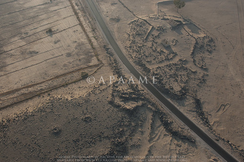
Qasr Ain el Beidha photographed in 2011 - the perimeter wall can just be seen to the left of the road in the picture. APAAME_20111027_MND-0079.  Please click to enlarge image.
Today, the site is lost except for a section of the perimeter wall. We were able to photograph what remains of the site in 2011. A bitumen road has been built since 1978 running east from Azraq straight through the site. Historical satellite imagery in Google Earth implies the road has been in existence since at least 2003. Photographs from the 1978 survey imply that the track had previously gone around the site.
Qasr Ain el Beidha general view c. 1981. The track can be seen running around to the right of the site in the photograph. Image © David Kennedy. Please click to enlarge image.