Showing posts with label Pioneers. Show all posts

Friday, 26 February 2016

Publications (Correction): Pioneers Above Jordan

It has just come to our attention that the article
David Kennedy 2012 'Pioneers Above Jordan: revealing a prehistoric landscape', Antiquity 86 (332): 474-491.
contains an error for the image and caption of figure 10.

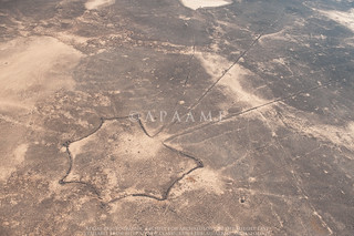
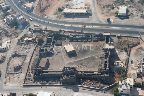
The image in the text is the following:
Ausaji Kite 28
Ausaji Kite 28. Photographer: David Kennedy (APAAME_20091008_DLK-0167).
The caption should identify the site as 'Ausaji Kite 28'.

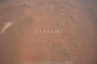
The caption in the published text is that for the following image:
Wisad Kite 14
Wisad Kite 14. Photographer: Robert Bewley (APAAME_20091004_RHB-0073).
The caption from the article reads as follows:
Wisad Kite 14 (APAAME 20091004 RHB-0073). A kite surrounded by an immense tangle of walls, few of them visible at ground level. In the top left is the Wisad Police Post on the Airmail Track.

Monday, 15 December 2014

Research: Robert Alexander MacLean

Amongst the pioneers of Aerial Archaeology – albeit on a peripheral level, is this enigmatic character.

The American Journal of Archaeology for January-March 1923 published the abstracts of lectures given the previous December at the annual conference of the Archaeological Institute of America (AIA). One abstract is entitled “The Aeroplane and archaeology”, the author a professor at University of Rochester in New York State. Sadly, never published and tantalizing because of what MacLean had to say:
“Among the many services which the aeroplane is rendering at the present time not the least is the aid which it is giving in archaeological discovery. In countries such as Mesopotamia where there are few maps to guide the archaeologist, and in portions of Arabia which are difficult of access by ordinary means of travel, the aeroplane has already proved to be a valuable subsidiary help in making preliminary surveys, and in locating historical ruins and the possible sites of ancient cities. Two illustrations will suffice. This last summer I went by aeroplane from Amman in Transjordania to visit some Roman ruins at ‘Kasr Azraq’ in the Syrian desert. … Another noteworthy feature was the presence on the oasis of about twenty pools of clear cold water surrounded by a Roman wall. It was interesting to observe that while this wall, only portions of which remain, could hardly be distinguished by an observer on the ground, its alignment and complete circuit of the pools could be seen clearly from the air.

My second illustration is from Mesopotamia. Among the many lost cities of ancient times may be mentioned two which Xenophon speaks of in the Anabasis …. Until quite recently the difficulty in determining the site of these two cities was due to the fact that the course of the Tigris in ancient times was not known to us. But by recent observations and photographs taken from the air it is now pretty well established that that portion of the Tigris which lies to the east of Xenophon's Median Wall had its bed about fifteen miles to the west of the present bed of the river. The depression seen from the air and the line of mounds along the depression were the clues which led to what is thought to be the discovery of the sites of both Opis and Sittace.”

Quite apart from what MacLean is ‘discovering’ from the air and what other aerial photographs he may have had, is the puzzle about how he came to be in a position to fly over these places at all, especially in the case of Azraq which was the specific object of the flight.
Qasr el-Azraq
Qasr el-Azraq today. APAAME_20080909_IAR-0205.
MacLean is an intriguing character and deserving of a fuller treatment which can to some extent be done thanks to a large number of small snippets of information available elsewhere. Here it is just possible to sketch a few details relevant to Aerial Archaeology at what is a very early date for such work in the Middle East – Poidebard only arrived in Syria to begin his flying programme in 1925.

MacLean, the son of Scottish immigrants to Canada, is said to have been:
“… teaching at the University of Manitoba when World War One broke out. He enlisted immediately, in August, 1914, in the Winnipeg Grenadiers and landed in England with the first Canadian contingent in October of that year. He was commissioned as an officer in the British Imperial Army in January, 1915, and served in France for eight months. In 1916 he was sent to the Middle East where he served in various capacities and in various countries - Mesopotamia, Persia, Arabia, and India. For the last year of the war he was engaged in political work, coming into contact with such personalities as Gertrude Bell, H. St. John Philby, Sir Percy Cox, and Col. T. E. Lawrence.”

He is described as having “served as staff captain under General Maude, being engaged particularly in intelligence and political work” and elsewhere he said he “arrived in Bagdad with the British army on 11 March 1917”. MacLean was soon moved westwards and is described as having been a “member of General Allenby’s staff when the British army marched on Jerusalem”.

In the magazine of his university he recounts the flight of 1922 which evidently included the flight to Azraq. Although he does not say so, he was evidently flying across Jordan and Iraq in one of the RAF aircraft of the newly developed Airmail Route from Egypt to Basra, initiated in June-July 1921. The few passengers carried were normally only service or important government personnel, implying MacLean had some influence.

MacLean explains he was in Baghdad as part of the celebration marking the laying of the foundation stone of the University of Baghdad and that he also met King Feisal. Returning west, his aeroplane had engine trouble and they had to land and spend a night in the desert.

There is much more one may add but two salient points to note are that MacLean is untraceable in the records of those who have spent many years researching military intelligence in the Middle East during the First World War. On the other hand, if he was – like that other oddity in the region, Richard Meinerzhagen, a fantasist, he nevertheless seems to have known enough people of influence to be given a flight to Azraq, taken on two trips on the new Airmail Route, perhaps also flown by the RAF in Iraq and supplied with some aerial photos for his lecture.

Sadly, one avenue of research is closed. MacLean’s sole child, a son, is long dead and had been estranged from his father for many years; the son’s children, brought up in France and French citizens, came to me for information about their grandfather.

But there must be some record of his First World War service and perhaps how that led to his flights in 1922. Perhaps he really did know Bell, Philby, Cox and Lawrence. In 1922 the senior British Political Officer in what they still called Transjordania was … Harry Philby. Shortly after MacLean flew across Jordan, Meinerzhagen crossed it on the ground. At the far end of the route, MacLean would have found the British residents of Baghdad included both Gertrude Bell (Oriental Secretary) and Sir Percy Cox (High Commissioner for Iraq).

Many of the personal details of MacLean’s long life and career have been traced as have his publications (including two books published privately). The gap is his military service.

– David Kennedy

Monday, 10 November 2014

Research: Pioneers - On a further personal note …

In a recent post on Insall, one of the three RAF pioneers in aerial reconnaissance over the Airmail Route and one of the first to publish an aerial photo of a Kite, I noted that a decade later he was the Station Commander of RAF Abu Sueir in Egypt where my father completed his flying training in 1936. I had long regretted that my father’s training at a Middle East base which was explicitly intended to produce pilots for service in the East, saw him posted to India for several years. Three of the other new pilots were posted to Iraq and one to No. 14(B) Squadron at Amman (killed shortly after in an accident).

In is now clear that although my father was never stationed in Iraq and Transjordan, he twice flew along the Airmail Route in those two Mandates. Putting together a few brief entries in his logbook, a handful of small photos and a postcard he sent to his brother-in-law back on the Northwest Frontier of British India, the episode is definable.
The 'Flying Boat' 'AWARUA'
About 17 July 1939 he was sent to Heliopolis in Egypt to collect and ferry back to India, one of the new Blenheim light bombers with which the RAF was being re-equipped. He recorded the flight on an Imperial Airways flying boat from Karachi via the Gulf and Habbaniya in Iraq to Tiberias on the Sea of Galilee and finally Alexandria – a two day journey. A few photos of the flying boat and a postcard from Tiberias:

Postcard from Tiberius.
I am having a marvellous time on board this flying boat ‘AWARUA’. We have just had Tiffin at Tiberias on Sea of Galilee.

By chance, that same flying boat was transferred the very next month to service in Australasia with Tasman Empire Airways Ltd (TEAL) on its NZ to Sydney route. As it happens there is a contemporary account now online of that delivery flight including:
Rapid refuel and then off towards Palestine where we land on the Sea of Galilee at Tiberius (sic), and here the skipper fills a special bottle with Galilee water to take to New Zealand for the christening of his new baby.
From Tiberius (sic) until we pass down into the Persian Gulf this next stretch is invariably hot and bumpy and the pipe line desert below never looks inviting especially when in a flying boat, …

My father’s logbook records his own flight back to India in August 1939, piloting his Blenheim:
5 August: Heliopolis – Habbaniya
5 August: Habbaniya – Shaibah
6 August: Shaibah – Sharjah
6 August: Sharjah – Karachi

That first stretch of 4 hours on 5th August would have largely retraced the Imperial Airways route across the Jordanian panhandle following the track alongside the oil pipeline which seems to have replaced the initial RAF track around the southern edge of the Harret ash-Shaam lavafield. Sadly he took no photos – almost 60 years before my own first flights in the same area.

- DLK

Thursday, 23 October 2014

Research: Gilbert Insall - Pioneer over Jordan … and Sinai and Iraq

Our recent flights over the Jordanian Panhandle have been a reminder of the RAF pioneers who discovered, photographed and published Kites in the 1920s. One of the principle trio was Gilbert Insall.

Insall had published a photograph of a Kite in 1929 (which has now been ‘rediscovered’ – Blog 'The First Kites') taken while he was commanding a squadron in Iraq. Several years later he was back in the Middle East as Station Commander of RAF Abu Sueir in Egypt, a Flying Training School. Edward Mole, the Chief Engineer at Abu Sueir in 1937-8, subsequently published a delightful autobiography of his RAF career including flights made with Insall. By then Insall was 42 and his enthusiasm for archaeology as undiminished. Mole records that Insall frequently flew out over Sinai, located sites, landed and set-to with the shovel and pick he carried with him. In case the C.O. got into trouble, Mole sometimes flew with him in another aircraft and was roped into the digging.
From above, the pattern of an old settlement could clearly be seen on the desert sand, and on sighting one, Insall would land nearby and dig for objects.

Later still, Insall and Mole flew together to Baghdad to visit RAF friends.
We set off together in two Audax aircraft to make the long trip across the featureless Arabian desert. There were no radio navigation aids in those days, but all we had to do was to find and follow the oil pipe line which ran straight as a die for hundreds of miles. We took with us all necessary desert flying equipment – emergency rations, water bottles, first aid kits – and Ghoolie Chits.

Interesting that by 1937-8, the air route across the Jordanian Panhandle had evidently shifted from the track and furrow ploughed for the RAF-pioneered Airmail Route of 12 years before along the southern fringe of the lavafield, to the much more straightforward line of the new oil pipeline further north. This was evidently the route followed by Imperial Airways when it took over the Airmail task from the RAF and explains the series of circular route-markers with numbers from (at least) 24 to 16 (as you flew east) (For an example see Flight 20141015 blog).

In Iraq, Insall had Mole fly him over Samarra so he could photograph it from the air – as he had had done when he flew Crawford there in 1928. Hopefully his aerial photos survive – his son had an RAF flying career, too, and is now a noted writer on archaeological work in Oman.

Abu Sueir, Sir P Sassoon, G Cpt Insall VC Inspecting Junior Term 1936.
On a personal note, Insall senior was the Station Commander at Abu Sueir when my father learned to fly there in 1936 and officiated at his Passing Out Parade.

- David Kennedy

Insall, G. S. M. (1929) “The aeroplane in archaeology”, Journal of the RAF College, Cranwell 9.2: 174-175.
Mole, E. (1984) Happy Landings, Shrewsbury.
Kennedy, D. L. (2012) “Pioneers Above Jordan. Revealing a prehistoric landscape”, Antiquity 86: 474-491.

Monday, 21 July 2014

Research: The first Kites

In 2012, David Kennedy’s ‘Pioneers above Jordan’ article acknowledged the contribution to aerial archaeology by Royal Air Force pilots flying on the Cairo-Baghdad Airmail Route. The individuals who published the first photographs of a site they had termed ‘Kites’ were Percy Eric Maitland (1895-1985), Lionel Wilmont Brabazon Rees (1884-1955) and Gilbert Stuart Martin Insall (1894-1972).
Maitland 1927 The 'Works of the Old Men' in Arabia, Antiquity 1 (2): plate III.
Maitland’s article in the second issue of the new Journal Antiquity introduced the wider world to the concept of the ‘Works of the Old Men’ using aerial photographs taken by the RAF during passes of the Cairo-Baghdad air mail route. On Plate III a most striking Kite is presented as ‘Walls and Fort in Basalt Country’ – this has been located as ‘Wisad Kite 40’ at 31°52'43.54"N, 37°55'59.01"E and can be clearly seen on Bing Maps despite the encroaching sands over the low basalt walls of the Kite. From the collection of aerial photographs taken back to the UK by O.G.S. Crawford (now housed in UCL Special Collections for the Institute of Archaeology) we know this photograph is actually a mosaic of a series of vertical photographs taken over the kite.
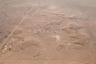
Wisad Wall Tangle 2
Wisad Wall Tangle 2: APAAME_20091004_DLK-0045. Photographer: David Kennedy.
The other photograph on the plate, ‘Walls and Enclosures in Basalt Country’ may picture part of a kite amongst a tangle of walls – but the complex is now interrupted by a road and the El-Wisad Desert Patrol Post so we cannot quite clarify what the principle structure may once have been. We have identified the site as ‘Wisad Wall Tangle 2’: 31°53'6.82"N, 37°57'17.33"E.

Rees published photographs and images of a few Kites in his article ‘The Transjordan Desert’, also in Antiquity, but later in 1929. In ‘Circles Etc. in the Basalt Country South-West of Azrak’ on Plate III you can see the kite located at 31°47'54.56"N, 36°43'15.56"E, which we have photographed as ‘Amra Kite 4’.
Rees 1929 The Transjordan Desert, Antiquity 3 (12): plate IV.
On Plate IV he shows a photograph of ‘Kites south of Kasr Azrak’ which is a well defined chain of Kites at 31°51'51.57"N, 36°48'46.89"E with Azraq Kite 46 the most prominent in the photograph, but today the Kites are almost destroyed beneath increased farming and development around Azraq.
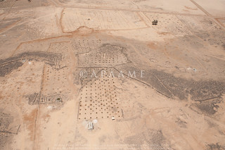
Azraq Kite 46 (Rees A)
Azraq Kite 46 in 2012 with a newly planted olive grove across the site. APAAME_20120522_DLK-0607. Photographer: David Kennedy.
In Plate VI he identifies a ‘Large Round Enclosure’ and two Kites on the photograph ‘Kazr Azrak and Surroundings’ but the ‘Large Round Enclosure’ is now entirely buried beneath the modern town (see Kennedy’s Big Circles article for information regarding this kind of feature), and one Kite, approximately 31°53'29.01"N, 36°50'5.39"E, is buried beneath the modern road, but the other is visible still at 31°53'39.43"N, 36°49'46.18"E. The photograph of ‘“Tell A”, near Landing-ground E’ on plate IX identifies several kites in the vicinity of the basalt mesa which can still be clearly seen from the air at 31°48'18.46"N, 37°25'59.97"E, and have been photographed and visited by the project several times.
Original RAF image from Insall (1929 The Aeroplane in Archaeology, Journal of the Royal Air Force College, Cranwell 9.2: between pages 174-175) juxtaposed with the modern imagery from Google Earth. Composed by Travis Hearn.
Also published in 1929 but less well known was Insall’s ‘The Aeroplane in Archaeology’ in the Journal of the Royal Air Force College, Cranwell (9.2: 174-175). The well defined kite with three tails he published eluded us for quite some time, but a review of the basalt region recently conducted identified the Kite at 31°47'51.06"N, 37°33'46.61"E alongside another Kite. Crossing the tails in the background can be seen the old bulldozed track laid out through the desert by the ground parties creating the new airmail route that acted as a guide for the pilots. More prominent now in the satellite imagery is a track bulldozed through the head.