Showing posts with label Site visits. Show all posts

Thursday, 29 January 2015

Flight 20141019 - A new Edomite Stronghold

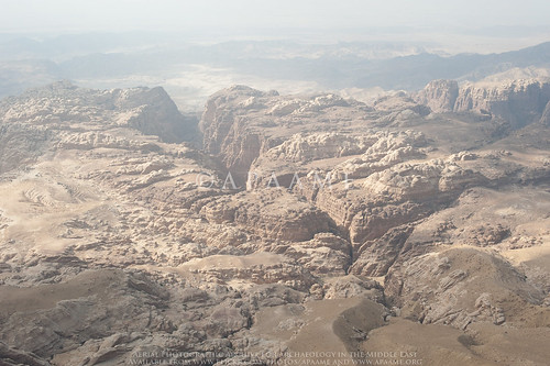
On Flight 20141019 from Amman to Aqaba six photographs were taken of the dramatic landscape looking west from Qasr Rajif over Wadi Suweid cutting through the sandstone peaks. Unbeknownst to us at the time, the photographs capture the site of an Edomite Fortress.
Wadi Suweid; el-Manktaa (Edomite Fortress)
'el-Manktaa' (Edomite Fortress) - APAAME_20141019_RHB-0287.
Prof. Chaim Ben David alerted us to the existence of the site, known as 'el-Manktaa' to the Bedouins, after he viewed the photographs on our Flickr. His ready knowledge and identification of the site probably due to the fact he had coincidentally visited it just a few months earlier.
The bridge to the site as seen from the wadi valley below. Photograph by Boaz Langford, courtesy of Chaim Ben David.
Following information from fellow hikers Eli Raz and Lior Enmar, who were aware of the phenomenon of Edomite mountain strongholds, in July 2014 Chaim visited two new, apparently as yet undocumented mountain strongholds in the sandstone area below the village of Rajef. The sites are about three kilometers south of Qseir, the southernmost known stronghold until this latest discovery.
Crossing the bridge to the site. Photograph by Boaz Langford, courtesy of Chaim Ben David.
The isolation of the site in the landscape is easily discernible on Google Maps (click here to go to the location). The small Bedouin constructed bridge used by Chaim and his companions to cross into the site can just be seen on the satellite imagery across the fissure that marks the western boundary of the stronghold. Structures are not readily visible on the satellite imagery, or on the low level obliques taken by AAJ, but photographs taken by Boaz Langford from the visit with Chaim show collapsed stone built structures.

Evidence of stone structures at the site. Photograph by Boaz Langford, courtesy of Chaim Ben David.
Chaim’s information means that we can add the coordinates of these sites to future AAJ flight routes, so that the site may be captured in full instead of in a lucky low level oblique landscape shot. Moreover, our better understanding of this type of site means in future we will be better able to discern these sites from the air. Chaim has offered his knowledge to the identification of many sites taken during the Aerial Archaeology in Jordan project's seasons of flying, and taken us on a couple of his amazing hikes across the landscape to investigate features further. Many thanks!

Following is an excerpt from Chaim Ben-David’s forthcoming publication in ARAM Periodical:
“You who live in the clefts of the rocks” (Jer.49:16): 
Edomite Mountain Strongholds in Southern Jordan

Thursday, 12 September 2013

Archive: Ground photographs

If you follow our Flickr archive you will have noticed we have been uploading a large amount of ground photographs over the last couple of days. What, you may ask, is an AERIAL photographic archive doing uploading so many ground photographs?

Well, in short, you cannot make sound conclusions from the aerial photographs unless you go and have a look on the ground – and this is why we have conducted so many ground visits. Additional information can easily be gathered without the need to conduct any formal excavation – such as if stone is worked or not, if there are large amounts of pottery scattered over the site, and whether there are any associated structures not easily visible from the air such as wine presses, cisterns etc.

This means that on our Flickr photostream you may compare the impression you get from a site as seen from the air with how that site appears on the ground. Ground photographs reference numbers are prefixed by APAAMEG (Or you can find them all in the collection here).

Something you may have noticed is that we are continually returning to sites. We revisit sites that are at particular risk or are constantly changing – such as Yajuz and the risks associated with the urban development of Amman, or the ongoing excavation, conservation and restoration projects at Jerash. A good excuse to visit sites again is when the team has a new member.

Something new to our Flickr archive and still being trialled with this most recent upload of ground images is the inclusion of ‘Pleiades’ tags. Pleiades (http://pleiades.stoa.org/) is an open source project developed by the Ancient World Mapping Centre, the Stoa Consortium and the Institute of the Ancient World. The database of sites is developed to act as a continually updated referenced atlas of the ancient world. They list 34,690 places and counting.

Each site has a unique identifier which you use to complete a ‘machine tag’: “Pleiades:depicts=******” if the site is depicted in the photograph, or “Pleaides:atteststo=*****” if the object photographed attests to the existence or location of the site- such as an inscription. There are other combinations too which you can read about on Sean Gillies blog.

By using these tags the Pleiades database recognises that we have photographs of their documented sites, and therefore people accessing their database of sites can easily access our photographs that relate to that site. Everyone ends up a winner! If you have feedback, please don’t forget to let us know.

If you are interested in the Pleiades project, or wish to become a contributor, please visit their website for more info.